Volume 79, Issue 3, 2001
NEBRASKAland
Nebraska Game & Parks Commission April 2001 $2.50
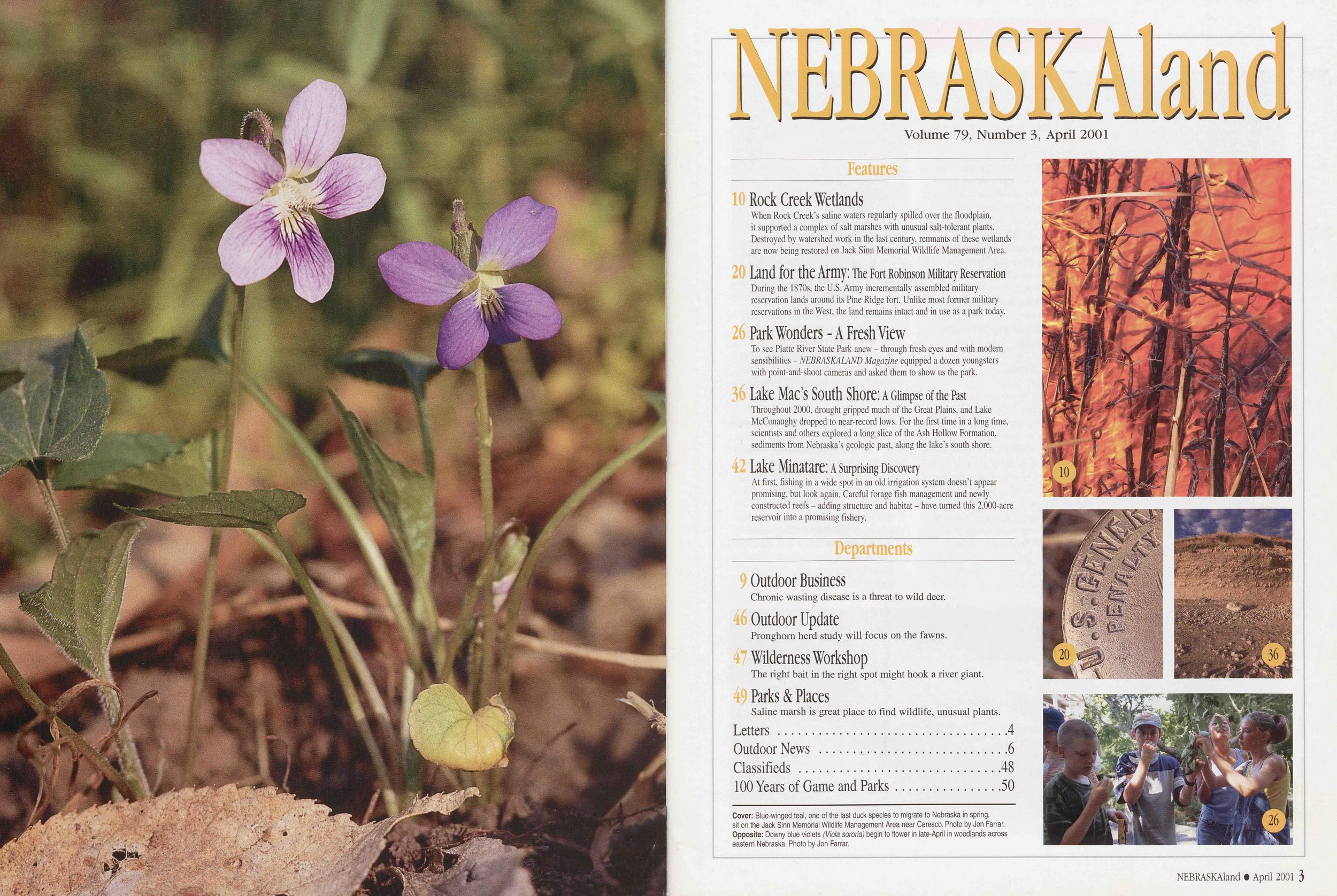
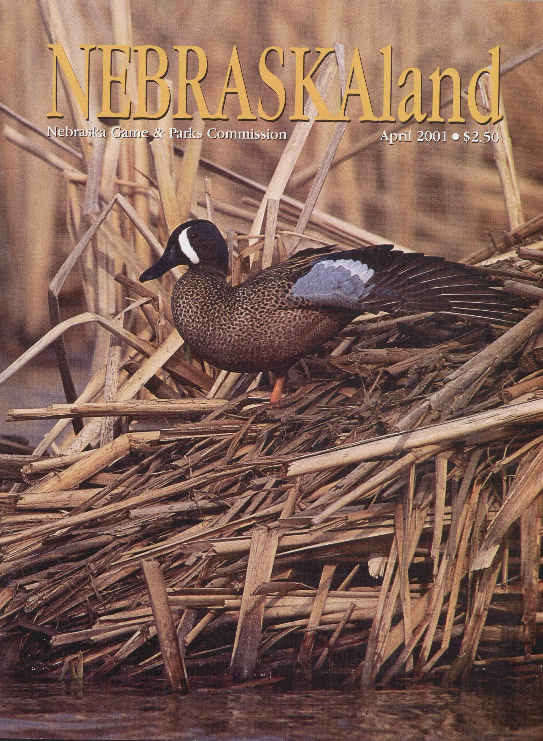
Cover: Blue-winged teal, one of the last duck species to migrate to Nebraska in spring, sit on the Jack Sinn Memorial Wildlife Management Area near Ceresco. Photo by Jon Farrar. Opposite: Downy blue violets (Viola sororia) begin to flower in late-April in woodlands across eastern Nebraska. Photo by Jon Farrar.
NEBRASKAland
Volume 79, Number 3, April 2001
10 Rock Creek Wetlands When Rock Creek’s saline waters regularly spilled over the floodplain, it supported a complex of salt marshes with unusual salt-tolerant plants. Destroyed by watershed work in the last century, remnants of these wetlands are now being restored on Jack Sinn Memorial Wildlife Management Area. 20 Land for the Army: The Fort Robinson Military Reservation During the 1870s, the U.S. Army incrementally assembled military reservation lands around its Pine Ridge fort. Unlike most former military reservations in the West, the land remains intact and in use as a park today. 26 Park Wonders - A Fresh View To see Platte River State Park anew - through fresh eyes and with modern sensibilities - NEBRASKALAND Magazine equipped a dozen youngsters with point-and-shoot cameras and asked them to show us the park. 36 Lake Mac’s South Shore: a Glimpse of the Past Throughout 2000, drought gripped much of the Great Plains, and Lake McConaughy dropped to near-record lows. For the first time in a long time, scientists and others explored a long slice of the Ash Hollow Formation, sediments from Nebraska’s geologic past, along the lake’s south shore. 42 Lake Minatare: A Surprising Discovery At first, fishing in a wide spot in an old irrigation system doesn’t appear promising, but look again. Careful forage fish management and newly constructed reefs - adding structure and habitat - have turned this 2,000-acre reservoir into a promising fishery. Departments 9 Outdoor Business Chronic wasting disease is a threat to wild deer. 46 Outdoor Update Pronghorn herd study will focus on the fawns. 47 Wilderness Workshop The right bait in the right spot might hook a river giant. 49 Parks & Places Saline marsh is great place to find wildlife, unusual plants. Letters 4 Outdoor News 6 Classifieds 48 100 Years of Game and Parks 5010
20
36
26
NEBRASKAland Magazine
Published by the Nebraska Game and Parks Commission Director: Rex Amack Assistant Directors: Noelyn Isom Roger Kuhn Kirk Nelson Information & Education Administrator: Paul Horton Information & Education Art Director: Steve O’Hare Commissioners Chairman: Rob Coupland, Valentine Vice Chairman: John P. Miller, Blair 2nd Vice Chairman: Connie Lapaseotes, Bridgeport George W. Egermayer Jr., Omaha Randall K. Stinnette, Inland Marvin Westcott, Holdrege James Stuart, Jr., Lincoln Magazine Staff Editor: Tom White Art Director: Tim Reigert Senior Editors: Ken Bouc, Jon Farrar Regional Editors: Bob Grier, Rocky Hoffmann Contributing Editors: Michael Forsberg, Tom Keith Circulation: Pat Frahm NEBRASKAland VOL. 79 / NO. 3 ISSN: 0028-1964 APRIL 2001 Published monthly, except for Jan./Feb. and Aug./Sept. issues, by the Nebraska Game and Parks Commission, 2200 N. 33rd St., Lincoln, NE. Copyright 2001, all rights reserved. Please address comments or questions to this address. Periodicals postage paid at Lincoln, Nebraska. POST- MASTER: Send all address changes to NEBRASKAland, P.O. Box 30370, Lincoln, NE 68503-0370. Address submissions to: The Editor, NEBRASKAland Magazine, P.O. Box 30370, Lincoln, NE 68503. Include a stamped, self-addressed return envelope. The publisher assumes no responsibility for unsolicited material. NEBRASKAland is available on audio cassette from the Nebraska Library Commission Talking Book and Braille Service, Suite 120, 1200 N St., Lincoln, NE 68508. Rates: $16 for one year; $30 for two years. Web site: www.ngpc.state.ne.us/neblandLetters
Should Trout Anglers Use Nets?Congratulations on a wonderful fishing edition [January-February 2001]. I learned a great deal about fishing in Nebraska, even though I thought I knew quite a bit.
One point of clarification, on page 103, you advise to avoid using a net when catching and releasing trout. In another part of the article, you identify “knotless catch-and-release nets” as an aid. I thought I was being a responsible fisherman by using a net. Now you have placed a doubt in my mind.
There is a picture within that article of a man holding a brown trout with a net in the background. Could you please expand on the use of nets. Thanks.
Tom Sams Kearney, NebraskaI live on a cove of Wagner’s Lake near Columbus. I have been feeding birds for 33 years. For the first time this winter, seven deer have come to the feeder in the early evening to eat bird seed.
They use their tongues to lick the seed out of the feeder. They came about 10 days in a row and then returned again a week later.
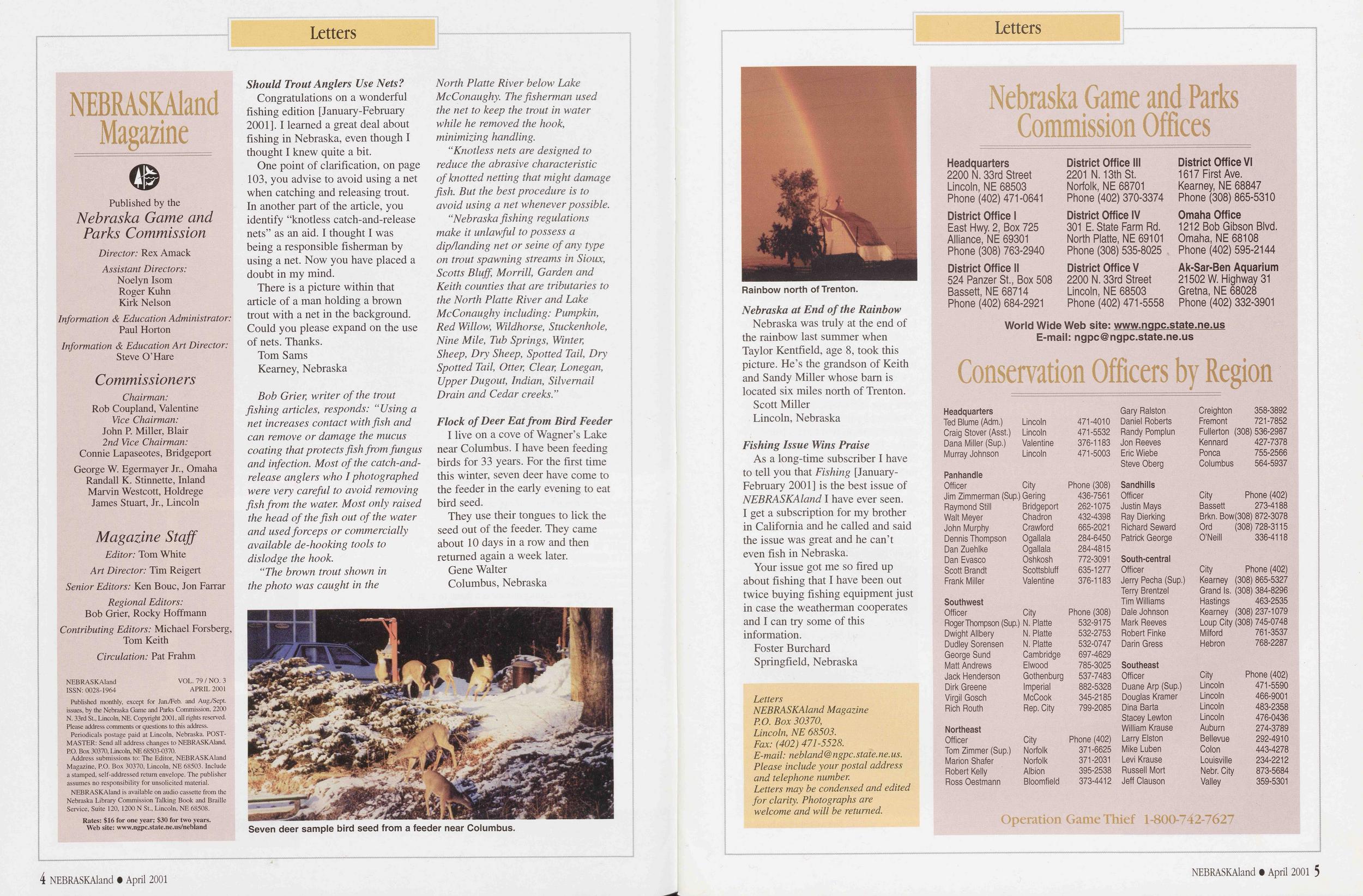
Gene Walter Columbus, NebraskaRainbow north of Trenton.
Nebraska was truly at the end of the rainbow last summer when Taylor Kentfield, age 8, took this picture. He’s the grandson of Keith and Sandy Miller whose bam is located six miles north of Trenton.
Scott Miller Lincoln, Nebraska Fishing Issue Wins PraiseAs a long-time subscriber I have to tell you that Fishing [January- February 2001] is the best issue of NEBRASKAland I have ever seen. I get a subscription for my brother in California and he called and said the issue was great and he can’t even fish in Nebraska.
Your issue got me so fired up about fishing that I have been out twice buying fishing equipment just in case the weatherman cooperates and I can try some of this information.
Foster Burchard Springfield, NebraskaNebraska Game and Parks Commission Offices
Headquarters 2200 N. 33rd Street Lincoln, NE 68503 Phone (402) 471-0641 District Office III 2201 N. 13th St. Norfolk, NE 68701 Phone (402) 370-3374 District Office VI 1617 First Ave. Kearney, NE 68847 Phone (308) 865-5310 District Office I District Office IV Omaha Office East Hwy. 2, Box 725 301 E. State Farm Rd. 1212 Bob Gibson Blvd. Alliance, NE 69301 North Platte, NE 69101 Omaha, NE 68108 Phone (308) 763-2940 Phone (308) 535-8025 Phone (402) 595-2144 District Office II District Office V Ak-Sar-Ben Aquarium 524 Panzer St., Box 508 2200 N. 33rd Street 21502 W. Highway 31 Bassett, NE 68714 Lincoln, NE 68503 Gretna, NE 68028 Phone (402) 684-2921 Phone (402) 471-5558 Phone (402) 332-3901 World Wide Web site: www.nqpc.state.ne.us E-mail: ngpc@ngpc.state.ne.us Conservation Officers by Region Headquarters Gary Ralston Creighton 358-3892 Ted Blume (Adm.) Lincoln 471-4010 Daniel Roberts Fremont 721-7852 Craig Stover (Asst.) Lincoln 471-5532 Randy Pomplun Fullerton (308) 536-2987 Dana Miller (Sup.) Valentine 376-1183 Jon Reeves Kennard 427-7378 Murray Johnson Lincoln 471-5003 Eric Wiebe Ponca 755-2566 Steve Oberg Columbus 564-5937 Panhandle Officer City Phone (308) Sandhills Jim Zimmerman (Sup.) Gering 436-7561 Officer City Phone (402) Raymond Still Bridgeport 262-1075 Justin Mays Bassett 273-4188 Walt Meyer Chadron 432-4398 Ray Dierking Brkn. Bow(308) 872-3078 John Murphy Crawford 665-2021 Richard Seward Ord (308) 728-3115 Dennis Thompson Ogallala 284-6450 Patrick George O’Neill 336-4118 Dan Zuehlke Ogallala 284-4815 Dan Evasco Oshkosh 772-3091 South-central Scott Brandt Scottsbluff 635-1277 Officer City Phone (402) Frank Miller Valentine 376-1183 Jerry Pecha (Sup.) Kearney (308) 865-5327 Terry Brentzel Grand Is. (308) 384-8296 Southwest Tim Williams Hastings 463-2535 Officer City Phone (308) Dale Johnson Kearney (308)237-1079 Roger Thompson (Sup.) N. Platte 532-9175 Mark Reeves Loup City (308) 745-0748 Dwight Allbery N. Platte 532-2753 Robert Finke Milford 761-3537 Dudley Sorensen N. Platte 532-0747 Darin Gress Hebron 768-2287 George Sund Cambridge 697-4629 Matt Andrews Elwood 785-3025 Southeast Jack Henderson Gothenburg 537-7483 Officer City Phone (402) Dirk Greene Imperial 882-5328 Duane Arp (Sup.) Lincoln 471-5590 Virgil Gosch McCook 345-2185 Douglas Kramer Lincoln 466-9001 Rich Routh Rep. City 799-2085 Dina Barta Lincoln 483-2358 Stacey Lewton Lincoln 476-0436 Northeast William Krause Auburn 274-3789 Officer City Phone (402) Larry Elston Bellevue 292-4910 Tom Zimmer (Sup.) Norfolk 371-6625 Mike Luben Colon 443-4278 Marion Shafer Norfolk 371-2031 Levi Krause Louisville 234-2212 Robert Kelly Albion 395-2538 Russell Mort Nebr. City 873-5684 Ross Oestmann Bloomfield 373-4412 Jeff Clauson Valley 359-5301 Operation Game Thief 1-800-742-7627 4 NEBRASKAland • April 2001 NEBRASKAland • April 2001 5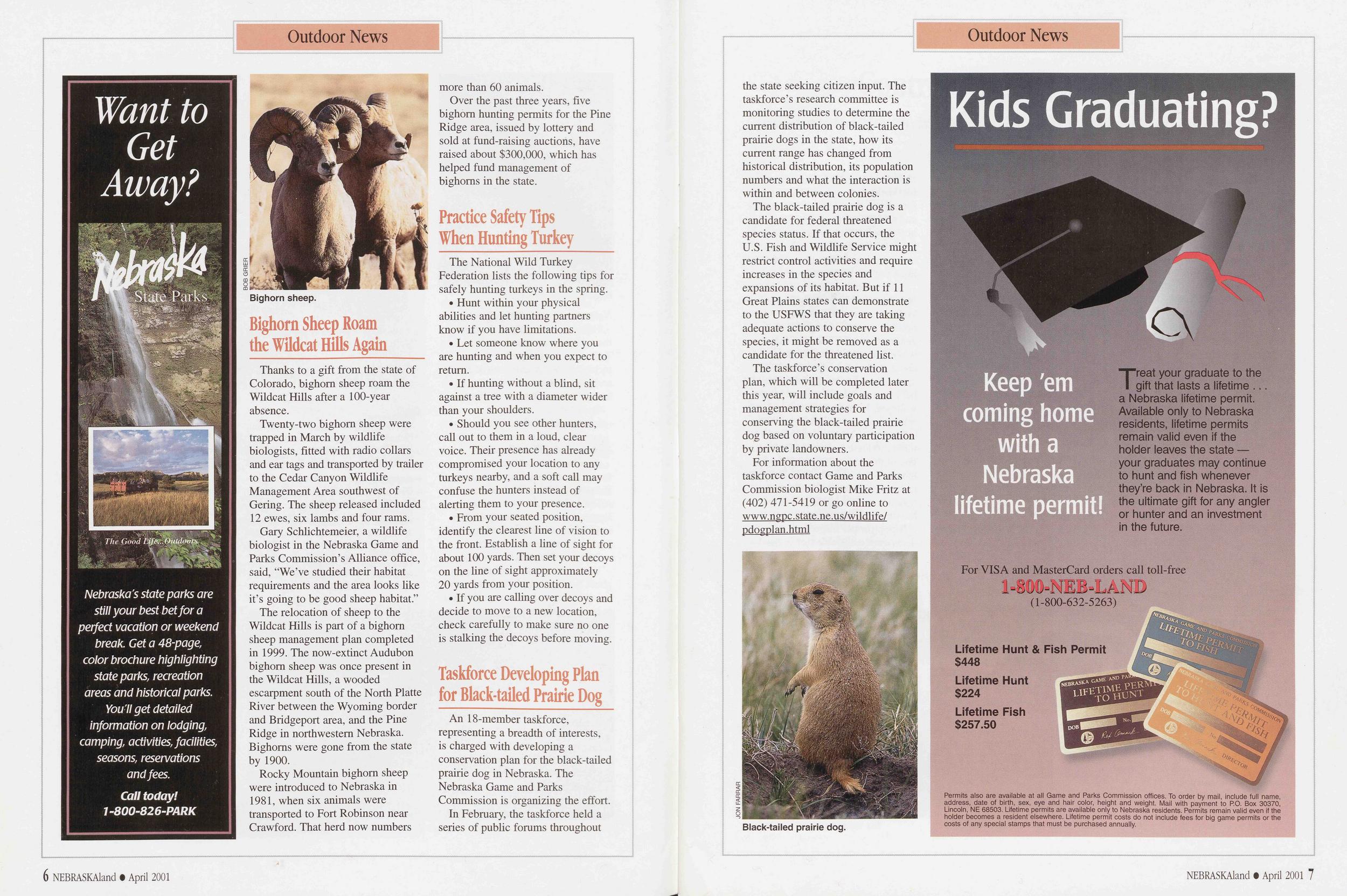
Want to Get Away
Nebraska's state parks are still your best bet for a perfect vacation or weekend break. Get a 48-page, color brochure highlighting state parks, recreation areas and historical parks. You 'll get detailed information on lodging, camping, activities, facilities, seasons, reservations and fees. Call today! 1-800-826-PARKOutdoor News
Bighorn sheep.
Thanks to a gift from the state of Colorado, bighorn sheep roam the Wildcat Hills after a 100-year absence.
Twenty-two bighorn sheep were trapped in March by wildlife biologists, fitted with radio collars and ear tags and transported by trailer to the Cedar Canyon Wildlife Management Area southwest of Gering. The sheep released included 12 ewes, six lambs and four rams.
Gary Schlichtemeier, a wildlife biologist in the Nebraska Game and Parks Commission’s Alliance office, said, "We’ve studied their habitat requirements and the area looks like it’s going to be good sheep habitat.”
The relocation of sheep to the Wildcat Hills is part of a bighorn sheep management plan completed in 1999. The now-extinct Audubon bighorn sheep was once present in the Wildcat Hills, a wooded escarpment south of the North Platte River between the Wyoming border and Bridgeport area, and the Pine Ridge in northwestern Nebraska. Bighorns were gone from the state by 1900.
Rocky Mountain bighorn sheep were introduced to Nebraska in 1981, when six animals were transported to Fort Robinson near Crawford. That herd now numbers more than 60 animals.
Over the past three years, five bighorn hunting permits for the Pine Ridge area, issued by lottery and sold at fund-raising auctions, have raised about $300,000, which has helped fund management of bighorns in the state.
Practice Safety Tips When Hunting TurkeyThe National Wild Turkey Federation lists the following tips for safely hunting turkeys in the spring.
• Hunt within your physical abilities and let hunting partners know if you have limitations.
• Let someone know where you are hunting and when you expect to return.
• If hunting without a blind, sit against a tree with a diameter wider than your shoulders.
• Should you see other hunters, call out to them in a loud, clear voice. Their presence has already compromised your location to any turkeys nearby, and a soft call may confuse the hunters instead of alerting them to your presence.
• From your seated position, identify the clearest line of vision to the front. Establish a line of sight for about 100 yards. Then set your decoys on the line of sight approximately 20 yards from your position.
• If you are calling over decoys and decide to move to a new location, check carefully to make sure no one is stalking the decoys before moving.
Taskforce Developing Plan for Black-tailed Prairie DogAn 18-member taskforce, representing a breadth of interests, is charged with developing a conservation plan for the black-tailed prairie dog in Nebraska. The Nebraska Game and Parks Commission is organizing the effort.
In February, the taskforce held a series of public forums throughout the state seeking citizen input. The taskforce’s research committee is monitoring studies to determine the current distribution of black-tailed prairie dogs in the state, how its current range has changed from historical distribution, its population numbers and what the interaction is within and between colonies.
The black-tailed prairie dog is a candidate for federal threatened species status. If that occurs, the U.S. Fish and Wildlife Service might restrict control activities and require increases in the species and expansions of its habitat. But if 11 Great Plains states can demonstrate to the USFWS that they are taking adequate actions to conserve the species, it might be removed as a candidate for the threatened list.
The taskforce’s conservation plan, which will be completed later this year, will include goals and management strategies for conserving the black-tailed prairie dog based on voluntary participation by private landowners.
For information about the taskforce contact Game and Parks Commission biologist Mike Fritz at (402) 471-5419 or go online to www.ngpc.state.ne.us/wildlife/ pdogplan.html
Black-tailed prairie dog.
Officer’s Notebook
My Four-legged Partner
For 14 years, Bo demonstrated field sense in making enforcement cases.
I became a conservation officer 17 years ago, patrolling about 4,000 square miles of the Nebraska Panhandle. Today, I still patrol the same 4,000 square miles but, thanks in part to a four-legged partner, I’ve developed much more field sense.
Shortly after joining the Nebraska Game and Parks Commission and completing my training, I bought a Chesapeake Bay retriever pup.
Bo and I became inseparable. I read the latest training methods and spent hours working with him. Reflecting back, I realize how important those hours were and, now I know, the bond between us was even more important.
Once discipline was established, the pup’s instincts took over; the little Chesapeake that I had intended to show the ropes took over the classroom.
I remember the ice fisherman on Oliver Reservoir with six trout on the ice in front of him as we approached. Sitting on a five-gallon bucket, he was working hard to catch his last fish. Just seven months old, Bo was already a veteran as he had tagged along several previous times while I checked fishermen. Bo always had to smell each fish before he settled beside me. As I visited with the fisherman, I was surprised when Bo broke from my side and began scratching the side of the bucket. The angler was irritated and pushed Bo away. Without getting up, he dug for his permit.
I called Bo to heel, but in no time he was back at it, scratching the bucket with both front paws. At this point, I caught on. I asked the fisherman to stand up and turn over the bucket. Inside there were four more trout. Bo had made his first case. It was a lesson I would have eventually learned on my own, but Bo wasn’t finished teaching me a thing or two.
That fall, while observing waterfowl hunters on the North Platte River near Scottsbluff, Bo made another case. A heavy fog hung over the river and visibility was poor. I was watching a group pass-shooting ducks in a cornfield off the river. The sky was black with ducks, but the visibility was so poor it was difficult to see birds dropping as the shooting continued.
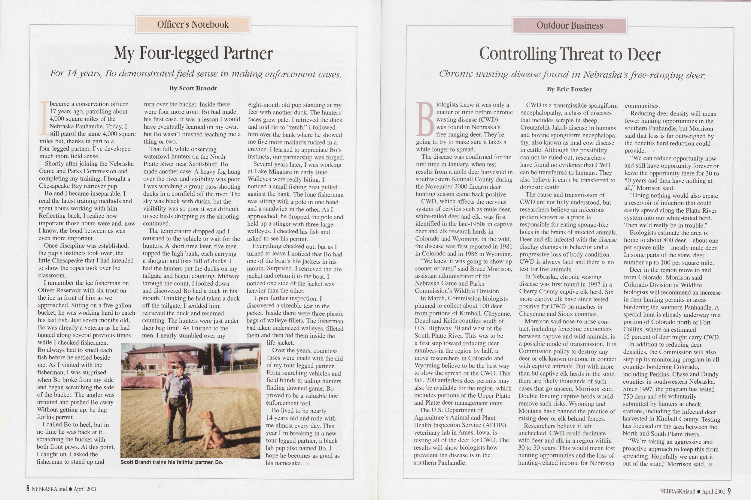
The temperature dropped and I returned to the vehicle to wait for the hunters. A short time later, five men topped the high bank, each carrying a shotgun and fists full of ducks. I had the hunters put the ducks on my tailgate and began counting. Midway through the count, I looked down and discovered Bo had a duck in his mouth. Thinking he had taken a duck off the tailgate, I scolded him, retrieved the duck and resumed counting. The hunters were just under their bag limit. As I turned to the men, I nearly stumbled over my Scott Brandt trains his faithful partner, Bo. eight-month old pup standing at my feet with another duck. The hunters’ faces grew pale. I retrieved the duck and told Bo to “fetch.” I followed him over the bank where he showed me five more mallards tucked in a crevice. I learned to appreciate Bo’s instincts; our partnership was forged.
Several years later, I was working at Lake Minatare in early June. Walleyes were really biting. I noticed a small fishing boat pulled against the bank. The lone fisherman was sitting with a pole in one hand and a sandwich in the other. As I approached, he dropped the pole and held up a stinger with three large walleyes. I checked his fish and asked to see his permit.
Everything checked out, but as I turned to leave I noticed that Bo had one of the boat’s life jackets in his mouth. Surprised, I retrieved the life jacket and return it to the boat. I noticed one side of the jacket was heavier than the other.
Upon further inspection, I discovered a sizeable tear in the jacket. Inside there were three plastic bags of walleye fillets. The fisherman had taken undersized walleyes, filleted them and then hid them inside the life jacket.
Over the years, countless cases were made with the aid of my four-legged partner. From searching vehicles and field blinds to aiding hunters finding downed game, Bo proved to be a valuable law enforcement tool.
Bo lived to be nearly 14 years old and rode with me almost every day. This year I’m breaking in a new four-legged partner, a black lab pup also named Bo. I hope he becomes as good as his namesake.
Outdoor Business
Controlling Threat to Deer
Chronic wasting disease found in Nebraska’s free-ranging deer.
Biologists knew it was only a matter of time before chronic wasting disease (CWD) was found in Nebraska’s free-ranging deer. They’re going to try to make sure it takes a while longer to spread.
The disease was confirmed for the first time in January, when test results from a mule deer harvested in southwestern Kimball County during the November 2000 firearm deer hunting season came back positive.
CWD, which affects the nervous system of cervids such as mule deer, white-tailed deer and elk, was first identified in the late-1960s in captive deer and elk research herds in Colorado and Wyoming. In the wild, the disease was first reported in 1981 in Colorado and in 1986 in Wyoming.
“We knew it was going to show up sooner or later,” said Bruce Morrison, assistant administrator of the Nebraska Game and Parks Commission’s Wildlife Division.
In March, Commission biologists planned to collect about 100 deer from portions of Kimball, Cheyenne, Deuel and Keith counties south of U.S. Highway 30 and west of the South Platte River. This was to be a first step toward reducing deer numbers in the region by half, a move researchers in Colorado and Wyoming believe to be the best way to slow the spread of the CWD. This fall, 200 antlerless deer permits may also be available for the region, which includes portions of the Upper Platte and Platte deer management units.
The U.S. Department of Agriculture’s Animal and Plant Health Inspection Service (APHIS) veterinary lab in Ames, Iowa, is testing all of the deer for CWD. The results will show biologists how prevalent the disease is in the southern Panhandle.
CWD is a transmissible spongiform encephalopathy, a class of diseases that includes scrapie in sheep, Creutzfeldt-Jakob disease in humans and bovine spongiform encephalopa- thy, also known as mad cow disease in cattle. Although the possibility can not be ruled out, researchers have found no evidence that CWD can be transferred to humans. They also believe it can’t be transferred to domestic cattle.
The cause and transmission of CWD are not fully understood, but researchers believe an infectious protein known as a prion is responsible for eating sponge-like holes in the brains of infected animals. Deer and elk infected with the disease display changes in behavior and a progressive loss of body condition. CWD is always fatal and there is no test for live animals.
In Nebraska, chronic wasting disease was first found in 1997 in a Cherry County captive elk herd. Six more captive elk have since tested positive for CWD on ranches in Cheyenne and Sioux counties.
Morrison said nose-to-nose con- tact, including fenceline encounters between captive and wild animals, is a possible mode of transmission. It is Commission policy to destroy any deer or elk known to come in contact with captive animals. But with more than 80 captive elk herds in the state, there are likely thousands of such cases that go unseen, Morrison said. Double fencing captive herds would remove such risks. Wyoming and Montana have banned the practice of raising deer or elk behind fences.
Researchers believe if left unchecked, CWD could decimate wild deer and elk in a region within 30 to 50 years. This would mean lost hunting opportunities and the loss of hunting-related income for Nebraska communities.
Reducing deer density will mean fewer hunting opportunities in the southern Panhandle, but Morrison said that loss is far outweighed by the benefits herd reduction could provide.
“We can reduce opportunity now and still have opportunity forever or leave the opportunity there for 30 to 50 years and then have nothing at all,” Morrison said.
“Doing nothing would also create a reservoir of infection that could easily spread along the Platte River system into our white-tailed herd. Then we’d really be in trouble.”
Biologists estimate the area is home to about 800 deer - about one per square mile - mostly mule deer. In some parts of the state, deer number up to 100 per square mile.
Deer in the region move to and from Colorado. Morrison said Colorado Division of Wildlife biologists will recommend an increase in deer hunting permits in areas bordering the southern Panhandle. A special hunt is already underway in a portion of Colorado north of Fort Collins, where an estimated 15 percent of deer might carry CWD.
In addition to reducing deer densities, the Commission will also step up its monitoring program in all counties bordering Colorado, including Perkins, Chase and Dundy counties in southwestern Nebraska. Since 1997, the program has tested 750 deer and elk voluntarily submitted by hunters at check stations, including the infected deer harvested in Kimball County. Testing has focused on the area between the North and South Platte rivers.
“We’re taking an aggressive and proactive approach to keep this from spreading. Hopefully we can get it out of the state,” Morrison said.
8 NEBRASKAland • April 2001 NEBRASKAland • April 2001 9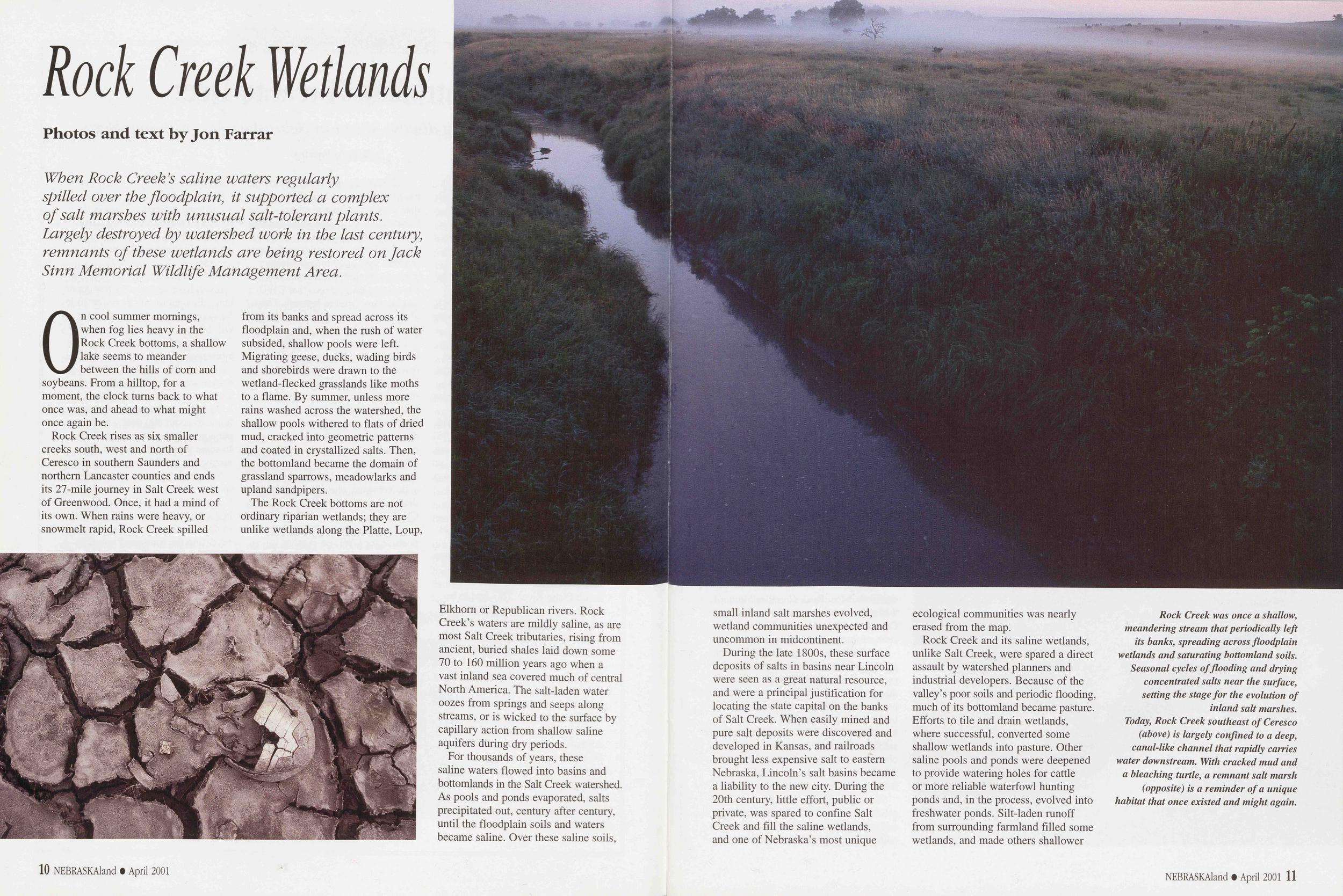
Rock Creek Wetlands
When Rock Creek’s saline waters regularly spilled over the floodplain, it supported a complex of salt marshes with unusual salt-tolerant plants. Largely destroyed by watershed work in the last century, remnants of these wetlands are being restored on Jack Sinn Memorial Wildlife Management Area.On cool summer mornings, when fog lies heavy in the Rock Creek bottoms, a shallow lake seems to meander between the hills of com and soybeans. From a hilltop, for a moment, the clock turns back to what once was, and ahead to what might once again be.
Rock Creek rises as six smaller creeks south, west and north of Ceresco in southern Saunders and northern Lancaster counties and ends its 27-mile journey in Salt Creek west of Greenwood. Once, it had a mind of its own. When rains were heavy, or snowmelt rapid, Rock Creek spilled from its banks and spread across its floodplain and, when the rush of water subsided, shallow pools were left. Migrating geese, ducks, wading birds and shorebirds were drawn to the wetland-flecked grasslands like moths to a flame. By summer, unless more rains washed across the watershed, the shallow pools withered to flats of dried mud, cracked into geometric patterns and coated in crystallized salts. Then, the bottomland became the domain of grassland sparrows, meadowlarks and upland sandpipers.
The Rock Creek bottoms are not ordinary riparian wetlands; they are unlike wetlands along the Platte, Loup, Elkhorn or Republican rivers. Rock Creek’s waters are mildly saline, as are most Salt Creek tributaries, rising from ancient, buried shales laid down some 70 to 160 million years ago when a vast inland sea covered much of central North America. The salt-laden water oozes from springs and seeps along streams, or is wicked to the surface by capillary action from shallow saline aquifers during dry periods.
For thousands of years, these saline waters flowed into basins and bottomlands in the Salt Creek watershed. As pools and ponds evaporated, salts precipitated out, century after century, until the floodplain soils and waters became saline. Over these saline soils, small inland salt marshes evolved, wetland communities unexpected and uncommon in midcontinent.
During the late 1800s, these surface deposits of salts in basins near Lincoln were seen as a great natural resource, and were a principal justification for locating the state capital on the banks of Salt Creek. When easily mined and pure salt deposits were discovered and developed in Kansas, and railroads brought less expensive salt to eastern Nebraska, Lincoln’s salt basins became a liability to the new city. During the 20th century, little effort, public or private, was spared to confine Salt Creek and fill the saline wetlands, and one of Nebraska’s most unique ecological communities was nearly erased from the map.
Rock Creek and its saline wetlands, unlike Salt Creek, were spared a direct assault by watershed planners and industrial developers. Because of the valley’s poor soils and periodic flooding, much of its bottomland became pasture. Efforts to tile and drain wetlands, where successful, converted some shallow wetlands into pasture. Other saline pools and ponds were deepened to provide watering holes for cattle or more reliable waterfowl hunting ponds and, in the process, evolved into freshwater ponds. Silt-laden runoff from surrounding farmland filled some wetlands, and made others shallower
Rock Creek was once a shallow, meandering stream that periodically left its banks, spreading across floodplain wetlands and saturating bottomland soils. Seasonal cycles offloading and drying concentrated salts near the surface, setting the stage for the evolution of inland salt marshes.
Today, Rock Creek southeast of Ceresco (above) is largely confined to a deep, canal-like channel that rapidly carries water downstream. With cracked mud and a bleaching turtle, a remnant salt marsh (opposite) is a reminder of a unique habitat that once existed and might again.
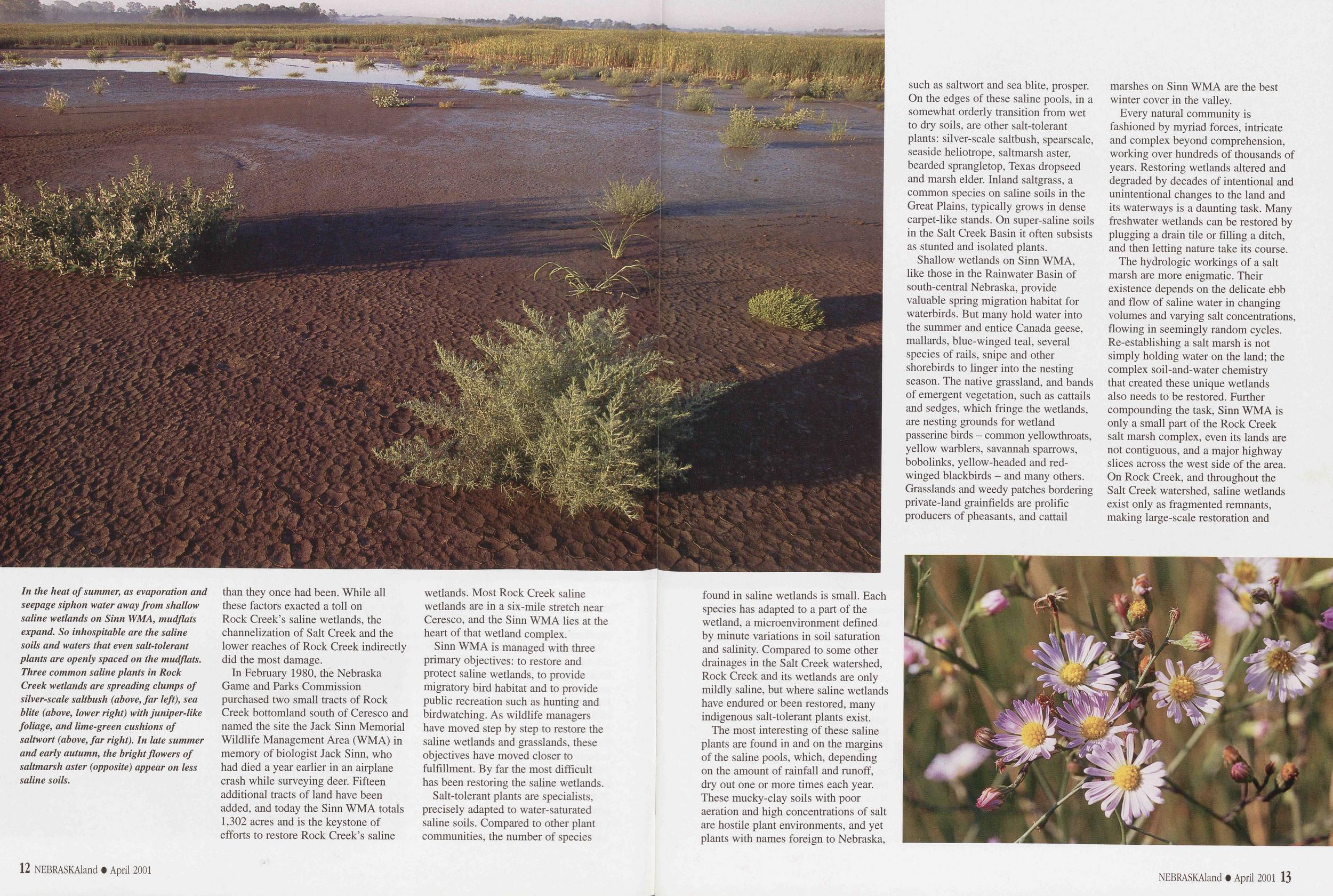
In the heat of summer, as evaporation and seepage siphon water away from shallow saline wetlands on Sinn WMA, mudflats expand. So inhospitable are the saline soils and waters that even salt-tolerant plants are openly spaced on the mudflats. Three common saline plants in Rock Creek wetlands are spreading clumps of silver-scale saltbush (above, far left), sea blite (above, lower right) with juniper-like foliage, and lime-green cushions of saltwort (above, far right). In late summer and early autumn, the bright flowers of saltmarsh aster (opposite) appear on less saline soils.
than they once had been. While all these factors exacted a toll on Rock Creek’s saline wetlands, the channelization of Salt Creek and the lower reaches of Rock Creek indirectly did the most damage.
In February 1980, the Nebraska Game and Parks Commission purchased two small tracts of Rock Creek bottomland south of Ceresco and named the site the Jack Sinn Memorial Wildlife Management Area (WMA) in memory of biologist Jack Sinn, who had died a year earlier in an airplane crash while surveying deer. Fifteen additional tracts of land have been added, and today the Sinn WMA totals 1,302 acres and is the keystone of efforts to restore Rock Creek’s saline wetlands. Most Rock Creek saline wetlands are in a six-mile stretch near Ceresco, and the Sinn WMA lies at the heart of that wetland complex.
Sinn WMA is managed with three primary objectives: to restore and protect saline wetlands, to provide migratory bird habitat and to provide public recreation such as hunting and birdwatching. As wildlife managers have moved step by step to restore the saline wetlands and grasslands, these objectives have moved closer to fulfillment. By far the most difficult has been restoring the saline wetlands.
Salt-tolerant plants are specialists, precisely adapted to water-saturated saline soils. Compared to other plant communities, the number of species found in saline wetlands is small. Each species has adapted to a part of the wetland, a microenvironment defined by minute variations in soil saturation and salinity. Compared to some other drainages in the Salt Creek watershed, Rock Creek and its wetlands are only mildly saline, but where saline wetlands have endured or been restored, many indigenous salt-tolerant plants exist.
The most interesting of these saline plants are found in and on the margins of the saline pools, which, depending on the amount of rainfall and runoff, dry out one or more times each year. These mucky-clay soils with poor aeration and high concentrations of salt are hostile plant environments, and yet plants with names foreign to Nebraska, such as saltwort and sea blite, prosper. On the edges of these saline pools, in a somewhat orderly transition from wet to dry soils, are other salt-tolerant plants: silver-scale saltbush, spearscale, seaside heliotrope, saltmarsh aster, bearded sprangletop, Texas dropseed and marsh elder. Inland saltgrass, a common species on saline soils in the Great Plains, typically grows in dense carpet-like stands. On super-saline soils in the Salt Creek Basin it often subsists as stunted and isolated plants.
Shallow wetlands on Sinn WMA, like those in the Rainwater Basin of south-central Nebraska, provide valuable spring migration habitat for waterbirds. But many hold water into the summer and entice Canada geese, mallards, blue-winged teal, several species of rails, snipe and other shorebirds to linger into the nesting season. The native grassland, and bands of emergent vegetation, such as cattails and sedges, which fringe the wetlands, are nesting grounds for wetland passerine birds - common yellowthroats, yellow warblers, savannah sparrows, bobolinks, yellow-headed and red- winged blackbirds - and many others. Grasslands and weedy patches bordering private-land grainfields are prolific producers of pheasants, and cattail
Every natural community is fashioned by myriad forces, intricate and complex beyond comprehension, working over hundreds of thousands of years. Restoring wetlands altered and degraded by decades of intentional and unintentional changes to the land and its waterways is a daunting task. Many freshwater wetlands can be restored by plugging a drain tile or filling a ditch, and then letting nature take its course.
The hydrologic workings of a salt marsh are more enigmatic. Their existence depends on the delicate ebb and flow of saline water in changing volumes and varying salt concentrations, flowing in seemingly random cycles. Re-establishing a salt marsh is not simply holding water on the land; the complex soil-and-water chemistry that created these unique wetlands also needs to be restored. Further compounding the task, Sinn WMA is only a small part of the Rock Creek salt marsh complex, even its lands are not contiguous, and a major highway slices across the west side of the area. On Rock Creek, and throughout the Salt Creek watershed, saline wetlands exist only as fragmented remnants, making large-scale restoration and 12 NEBRASKAland • April 2001 NEBRASKAland • April 2001 13 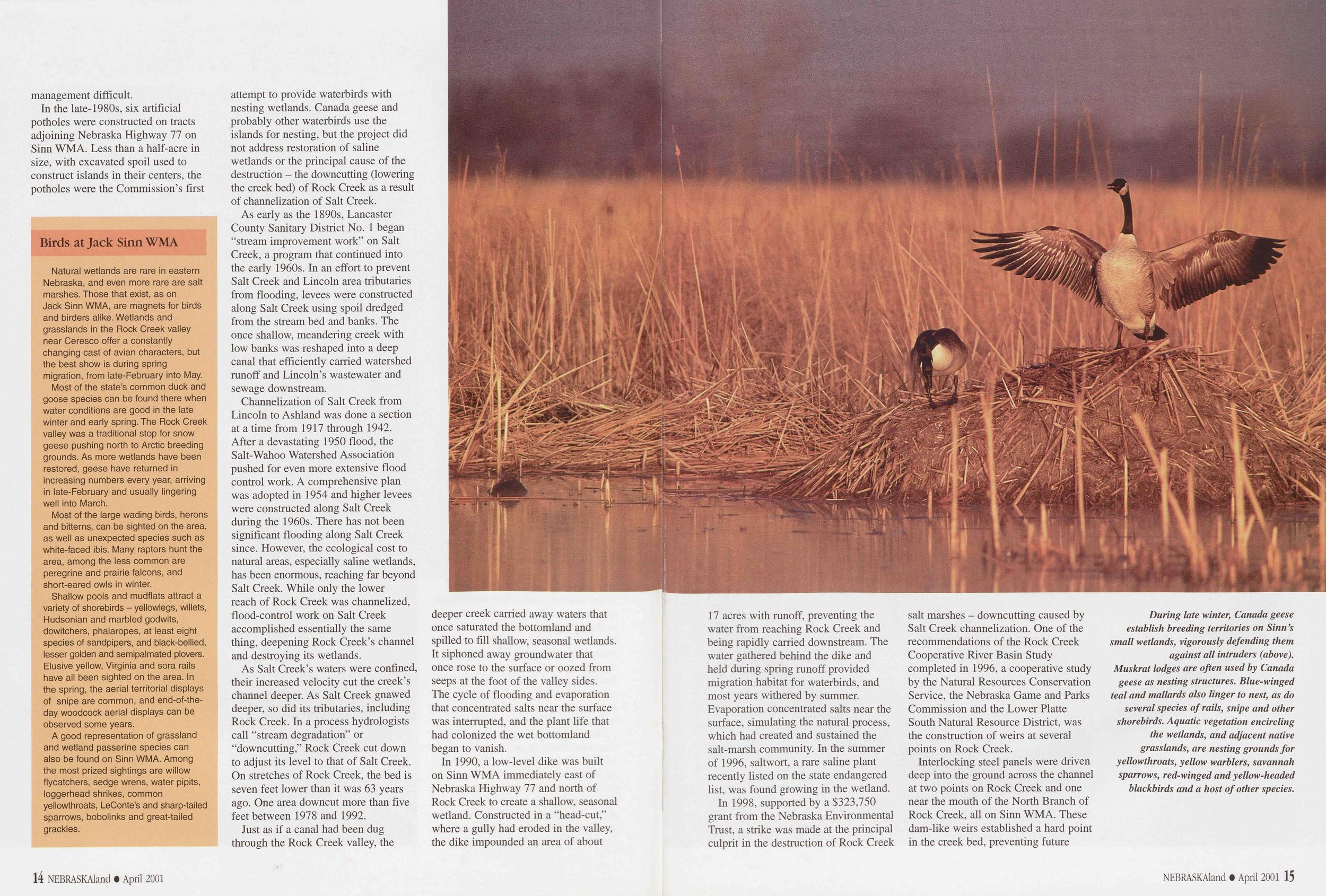 management difficult.
In the late-1980s, six artificial potholes were constructed on tracts adjoining Nebraska Highway 77 on Sinn WMA. Less than a half-acre in size, with excavated spoil used to construct islands in their centers, the potholes were the Commission’s first
Birds at Jack Sinn WMA
Natural wetlands are rare in eastern Nebraska, and even more rare are salt marshes. Those that exist, as on Jack Sinn WMA, are magnets for birds and birders alike. Wetlands and grasslands in the Rock Creek valley near Ceresco offer a constantly changing cast of avian characters, but the best show is during spring migration, from late-February into May.
Most of the state’s common duck and goose species can be found there when water conditions are good in the late winter and early spring. The Rock Creek valley was a traditional stop for snow geese pushing north to Arctic breeding grounds. As more wetlands have been restored, geese have returned in increasing numbers every year, arriving in late-February and usually lingering well into March.
Most of the large wading birds, herons and bitterns, can be sighted on the area, as well as unexpected species such as white-faced ibis. Many raptors hunt the area, among the less common are peregrine and prairie falcons, and short-eared owls in winter.
Shallow pools and mudflats attract a variety of shorebirds - yellowlegs, willets, Hudsonian and marbled godwits, dowitchers, phalaropes, at least eight species of sandpipers, and black-bellied, lesser golden and semipalmated plovers. Elusive yellow, Virginia and sora rails have all been sighted on the area. In the spring, the aerial territorial displays of snipe are common, and end-of-the- day woodcock aerial displays can be observed some years.
A good representation of grassland and wetland passerine species can also be found on Sinn WMA. Among the most prized sightings are willow flycatchers, sedge wrens, water pipits, loggerhead shrikes, common yellowthroats, LeConte’s and sharp-tailed sparrows, bobolinks and great-tailed grackles.
attempt to provide waterbirds with nesting wetlands. Canada geese and probably other waterbirds use the islands for nesting, but the project did not address restoration of saline wetlands or the principal cause of the destruction - the downcutting (lowering the creek bed) of Rock Creek as a result of channelization of Salt Creek.
As early as the 1890s, Lancaster County Sanitary District No. 1 began “stream improvement work” on Salt Creek, a program that continued into the early 1960s. In an effort to prevent Salt Creek and Lincoln area tributaries from flooding, levees were constructed along Salt Creek using spoil dredged from the stream bed and banks. The once shallow, meandering creek with low banks was reshaped into a deep canal that efficiently carried watershed runoff and Lincoln’s wastewater and sewage downstream.
Channelization of Salt Creek from Lincoln to Ashland was done a section at a time from 1917 through 1942. After a devastating 1950 flood, the Salt-Wahoo Watershed Association pushed for even more extensive flood control work. A comprehensive plan was adopted in 1954 and higher levees were constructed along Salt Creek during the 1960s. There has not been significant flooding along Salt Creek since. However, the ecological cost to natural areas, especially saline wetlands, has been enormous, reaching far beyond Salt Creek. While only the lower reach of Rock Creek was channelized, flood-control work on Salt Creek accomplished essentially the same thing, deepening Rock Creek’s channel and destroying its wetlands.
As Salt Creek’s waters were confined, their increased velocity cut the creek’s channel deeper. As Salt Creek gnawed deeper, so did its tributaries, including Rock Creek. In a process hydrologists call “stream degradation” or “downcutting,” Rock Creek cut down to adjust its level to that of Salt Creek. On stretches of Rock Creek, the bed is seven feet lower than it was 63 years ago. One area downcut more than five feet between 1978 and 1992.
Just as if a canal had been dug through the Rock Creek valley, the deeper creek carried away waters that once saturated the bottomland and spilled to fill shallow, seasonal wetlands. It siphoned away groundwater that once rose to the surface or oozed from seeps at the foot of the valley sides. The cycle of flooding and evaporation that concentrated salts near the surface was interrupted, and the plant life that had colonized the wet bottomland began to vanish.
In 1990, a low-level dike was built on Sinn WMA immediately east of Nebraska Highway 77 and north of Rock Creek to create a shallow, seasonal wetland. Constructed in a “head-cut,” where a gully had eroded in the valley, the dike impounded an area of about 17 acres with runoff, preventing the water from reaching Rock Creek and being rapidly carried downstream. The water gathered behind the dike and held during spring runoff provided migration habitat for waterbirds, and most years withered by summer. Evaporation concentrated salts near the surface, simulating the natural process, which had created and sustained the salt-marsh community. In the summer of 1996, saltwort, a rare saline plant recently listed on the state endangered list, was found growing in the wetland.
In 1998, supported by a $323,750 grant from the Nebraska Environmental Trust, a strike was made at the principal culprit in the destruction of Rock Creek salt marshes - downcutting caused by Salt Creek channelization. One of the recommendations of the Rock Creek Cooperative River Basin Study completed in 1996, a cooperative study by the Natural Resources Conservation Service, the Nebraska Game and Parks Commission and the Lower Platte South Natural Resource District, was the construction of weirs at several points on Rock Creek.
Interlocking steel panels were driven deep into the ground across the channel at two points on Rock Creek and one near the mouth of the North Branch of Rock Creek, all on Sinn WMA. These dam-like weirs established a hard point in the creek bed, preventing future
During late winter, Canada geese establish breeding territories on Sinn’s small wetlands, vigorously defending them against all intruders (above). Muskrat lodges are often used by Canada geese as nesting structures. Blue-winged teal and mallards also linger to nest, as do several species of rails, snipe and other shorebirds. Aquatic vegetation encircling the wetlands, and adjacent native grasslands, are nesting grounds for yellowthroats, yellow warblers, savannah sparrows, red-winged and yellow-headed blackbirds and a host of other species.
downcutting of the channel above those points. The weirs were constructed at an elevation only high enough to allow the upstream creek bed to fill with about one foot of silt, and will not result in water spilling out of the creek onto private land.
The most severe downcutting on Rock Creek begins about two miles downstream from the Sinn WMA. Without the weirs in place, it was only a matter of time before severe downcutting proceeded farther upstream. It will be years before the full benefit of the channel weirs is seen, but signs of recovery are already evident.
Also in the late 1990s, seven additional low-level dikes were built on the floodplain of the Sinn WMA to capture and hold runoff from valley sides, seeps and small eroding drainages. Funding for their construction was the same environmental trust grant used for installation of the weirs. The largest of these dikes impounds 70 acres of shallow water, but most of the dikes are small, creating pools of about one acre.
The dikes’ purpose is to plug the headcuts and keep water on the area, preventing it from escaping downstream and restoring historical wetland conditions.
Compared to decades of deterioration and disruption of Rock Creek’s natural hydrology, these are small efforts, but with substantial price tags. A host of public agencies and private conservation organizations have cooperated to make it possible. Efforts to preserve Rock Creek’s small and vanishing saline wetlands are also being made on private land. The Lower Platte South Natural Resource District conservation easement program has targeted saline
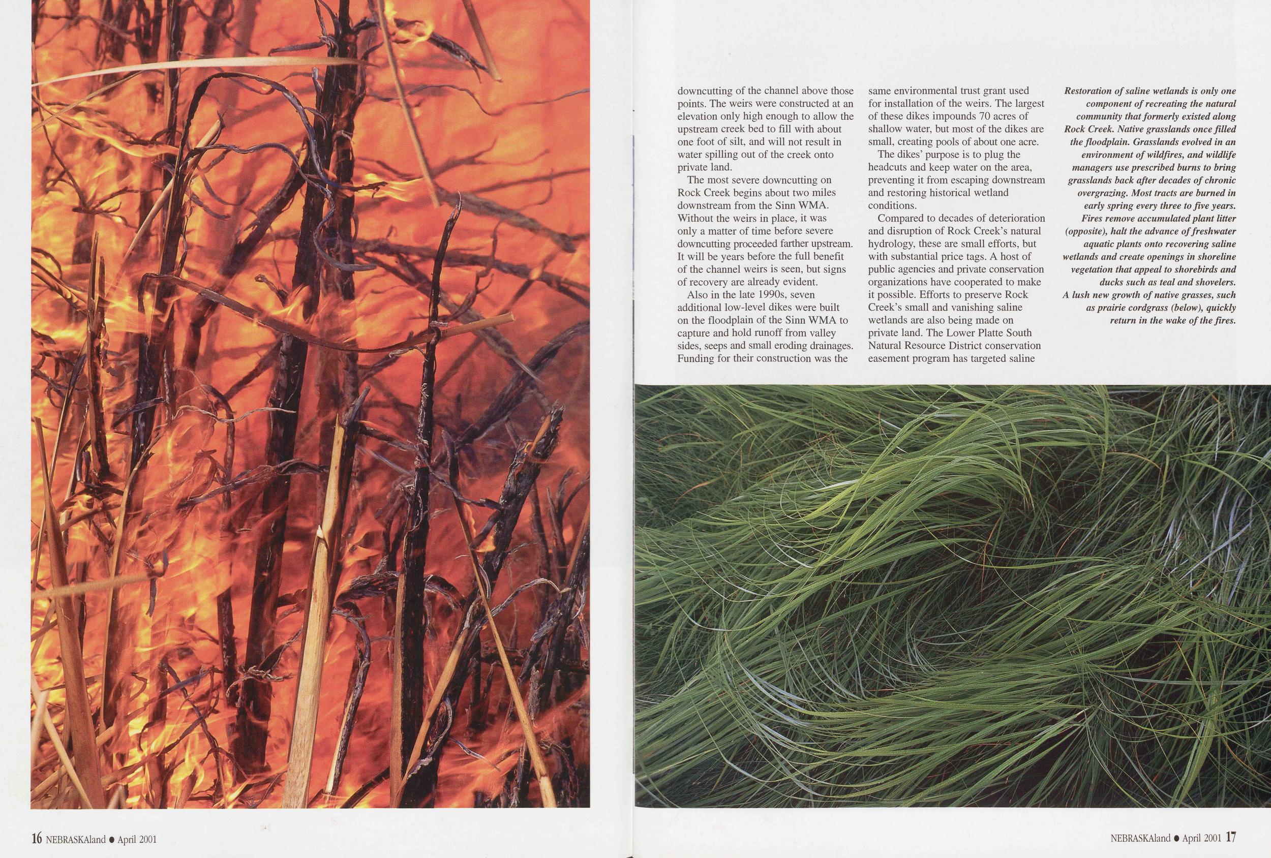
Restoration of saline wetlands is only one component of recreating the natural community that formerly existed along Rock Creek. Native grasslands once filled the floodplain. Grasslands evolved in an environment of wildfires, and wildlife managers use prescribed burns to bring grasslands back after decades of chronic overgrazing. Most tracts are burned in early spring every three to five years. Fires remove accumulated plant litter (opposite), halt the advance of freshwater aquatic plants onto recovering saline wetlands and create openings in shoreline vegetation that appeal to shorebirds and ducks such as teal and shovelers. A lush new growth of native grasses, such as prairie cordgrass (below), quickly return in the wake of the fires.
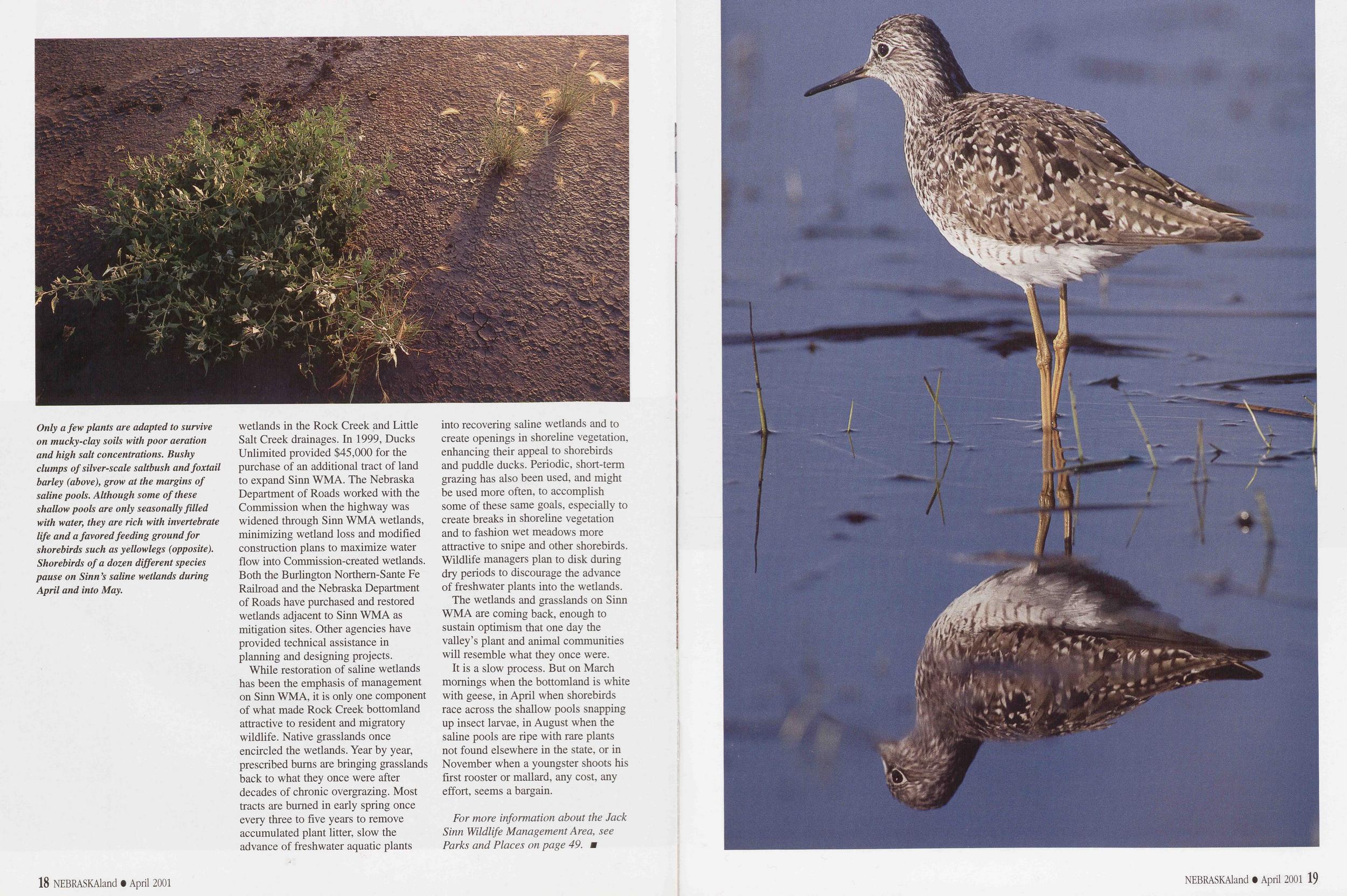
Only a few plants are adapted to survive on mucky-clay soils with poor aeration and high salt concentrations. Bushy clumps of silver-scale saltbush and foxtail barley (above), grow at the margins of saline pools. Although some of these shallow pools are only seasonally filled with water, they are rich with invertebrate life and a favored feeding ground for shorebirds such as yellowlegs (opposite). Shorebirds of a dozen different species pause on Sinn’s saline wetlands during April and into May.
wetlands in the Rock Creek and Little Salt Creek drainages. In 1999, Ducks Unlimited provided $45,000 for the purchase of an additional tract of land to expand Sinn WMA. The Nebraska Department of Roads worked with the Commission when the highway was widened through Sinn WMA wetlands, minimizing wetland loss and modified construction plans to maximize water flow into Commission-created wetlands. Both the Burlington Northem-Sante Fe Railroad and the Nebraska Department of Roads have purchased and restored wetlands adjacent to Sinn WMA as mitigation sites. Other agencies have provided technical assistance in planning and designing projects.
While restoration of saline wetlands has been the emphasis of management on Sinn WMA, it is only one component of what made Rock Creek bottomland attractive to resident and migratory wildlife. Native grasslands once encircled the wetlands. Year by year, prescribed bums are bringing grasslands back to what they once were after decades of chronic overgrazing. Most tracts are burned in early spring once every three to five years to remove accumulated plant litter, slow the advance of freshwater aquatic plants into recovering saline wetlands and to create openings in shoreline vegetation, enhancing their appeal to shorebirds and puddle ducks. Periodic, short-term grazing has also been used, and might be used more often, to accomplish some of these same goals, especially to create breaks in shoreline vegetation and to fashion wet meadows more attractive to snipe and other shorebirds. Wildlife managers plan to disk during dry periods to discourage the advance of freshwater plants into the wetlands.
The wetlands and grasslands on Sinn WMA are coming back, enough to sustain optimism that one day the valley’s plant and animal communities will resemble what they once were.
It is a slow process. But on March mornings when the bottomland is white with geese, in April when shorebirds race across the shallow pools snapping up insect larvae, in August when the saline pools are ripe with rare plants not found elsewhere in the state, or in November when a youngster shoots his first rooster or mallard, any cost, any effort, seems a bargain.
LAND FOR THE ARMY
The Fort Robinson Military Reservation
During the 1870s, the U.S. Army incrementally assembled military reservation lands around its Pine Ridge fort. Unlike most former military sites in the West, these lands remain intact today.Across the country numerous old military forts are preserved as historic sites, but on the upper Plains, it is unusual for the accompanying military reservation lands to remain intact and still under public ownership. Fort Robinson State Park is an exception.
A military reservation is defined as "land set aside from the public domain by the President of the United States for military purposes.” After an army post was established, commanders invariably recommended a surrounding area of land to be reserved. The president then would declare the land removed from homestead or other civilian development.
Civilians, unless employed by the army, were prohibited from residing or building improvements on military reservations. The law also forbade civilians from harvesting wood, grass, or grazing "any cattle, horses, hogs or other livestock” on reserved army land. Military reservations effectively controlled both the physical and commercial environs near frontier posts.
The area that became Fort Robinson reservation was well known to Euroamericans before the post was built on the White River. Between the 1830s and 1850s, the Fort Laramie-Fort Pierre Fur Trade Trail passed through the valley. When Captain Stewert Van Vliet led a small detachment of troops along that route in 1849, it was the first military presence in the area. Six years later, Lieutenant Gouveneur K. Warren, the topographic engineer with the Harney Expedition, mapped the area and named a large drainage entering White River from the northwest “Soldier Creek.”
By the summer of 1874, troops had been dispatched to guard Red Cloud Agency near the confluence of Soldier Creek and White River. Before building the post, Captain William Jordan was instructed to set aside a square-mile reservation around it and to "keep all unauthorized people (including Indians) from residing within the limits thereof.”
Jordan announced the reservation in post orders on September 4, but the president did not officially declare the area Camp Robinson’s first reservation. Because there was a question whether the Indian agency and its adjacent military post would remain on White River, the formality of declaring a permanent reservation was delayed until the post’s future could be decided. However, post commanders had established limits of control and an area to which the soldiers could be restricted when necessary.
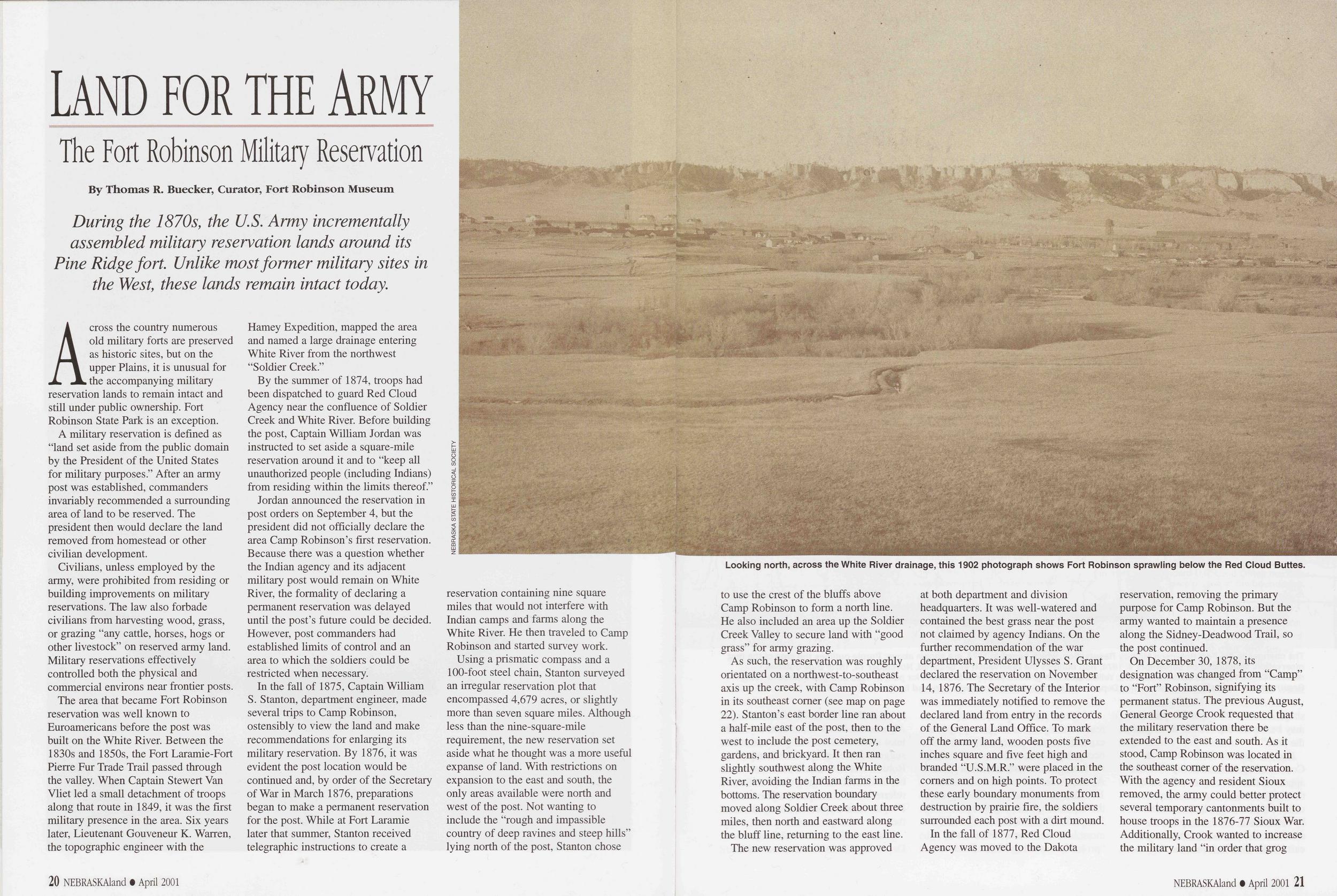
Looking north, across the White River drainage, this 1902 photograph shows Fort Robinson sprawling below the Red Cloud Buttes.
Using a prismatic compass and a 100-foot steel chain, Stanton surveyed an irregular reservation plot that encompassed 4,679 acres, or slightly more than seven square miles. Although less than the nine-square-mile requirement, the new reservation set aside what he thought was a more useful expanse of land. With restrictions on expansion to the east and south, the only areas available were north and west of the post. Not wanting to include the "rough and impassible country of deep ravines and steep hills” lying north of the post, Stanton chose to use the crest of the bluffs above Camp Robinson to form a north line. He also included an area up the Soldier Creek Valley to secure land with “good grass” for army grazing.
As such, the reservation was roughly orientated on a northwest-to-southeast axis up the creek, with Camp Robinson in its southeast comer (see map on page 22). Stanton’s east border line ran about a half-mile east of the post, then to the west to include the post cemetery, gardens, and brickyard. It then ran slightly southwest along the White River, avoiding the Indian farms in the bottoms. The reservation boundary moved along Soldier Creek about three miles, then north and eastward along the bluff line, returning to the east line.
The new reservation was approved at both department and division headquarters. It was well-watered and contained the best grass near the post not claimed by agency Indians. On the further recommendation of the war department, President Ulysses S. Grant declared the reservation on November 14, 1876. The Secretary of the Interior was immediately notified to remove the declared land from entry in the records of the General Land Office. To mark off the army land, wooden posts five inches square and five feet high and branded "U.S.M.R.” were placed in the comers and on high points. To protect these early boundary monuments from destruction by prairie fire, the soldiers surrounded each post with a dirt mound.
In the fall of 1877, Red Cloud Agency was moved to the Dakota reservation, removing the primary purpose for Camp Robinson. But the army wanted to maintain a presence along the Sidney-Deadwood Trail, so the post continued.
On December 30, 1878, its designation was changed from "Camp” to “Fort” Robinson, signifying its permanent status. The previous August, General George Crook requested that the military reservation there be extended to the east and south. As it stood, Camp Robinson was located in the southeast comer of the reservation. With the agency and resident Sioux removed, the army could better protect several temporary cantonments built to house troops in the 1876-77 Sioux War. Additionally, Crook wanted to increase the military land "in order that grog
20 NEBRASKAland • April 2001 NEBRASKAland • April 2001 21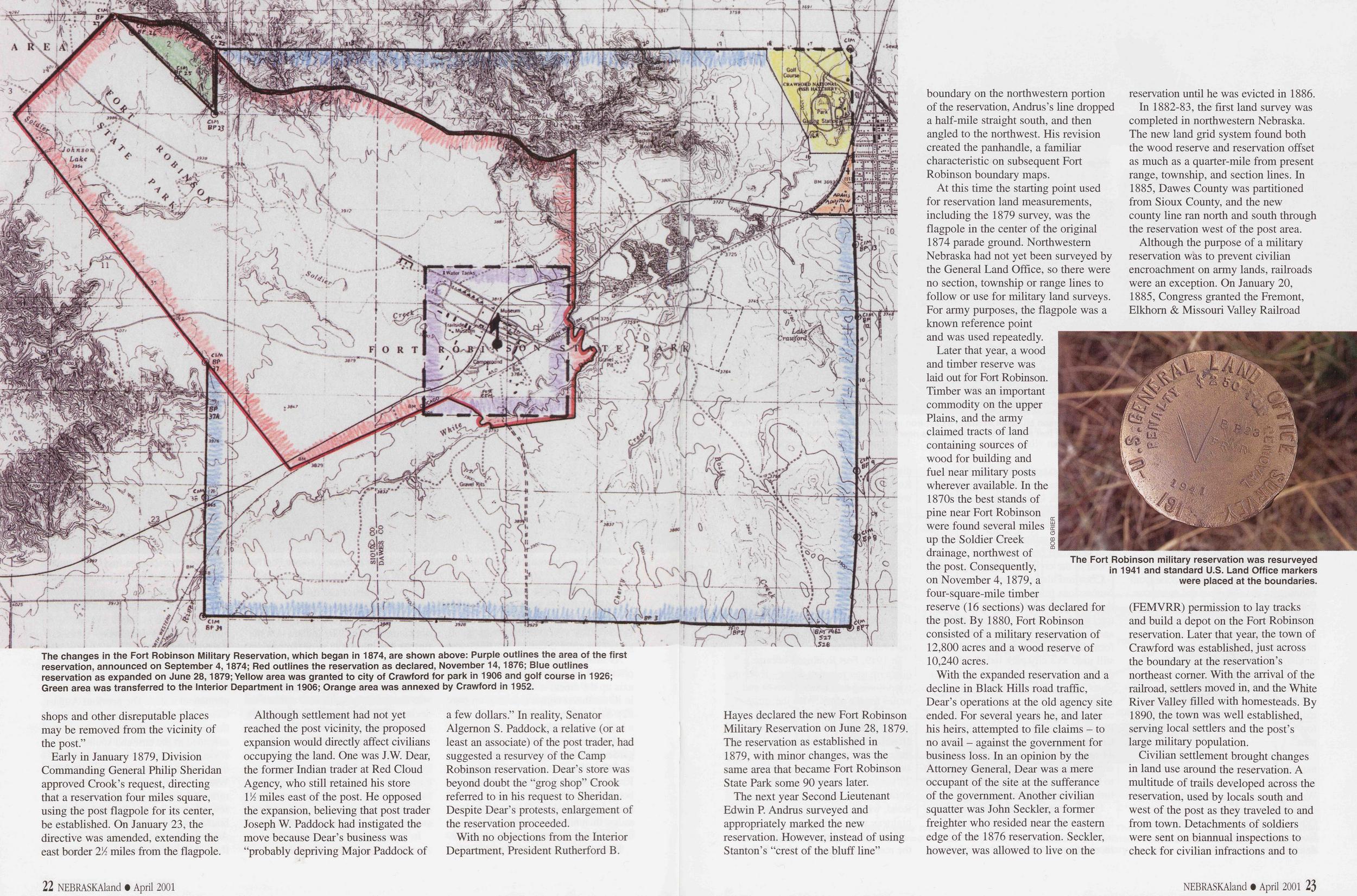
The changes in the Fort Robinson Military Reservation, which began in 1874, are shown above: Purple outlines the area of the first reservation, announced on September 4,1874; Red outlines the reservation as declared, November 14,1876; Blue outlines reservation as expanded on June 28,1879; Yellow area was granted to city of Crawford for park in 1906 and golf course in 1926; Green area was transferred to the Interior Department in 1906; Orange area was annexed by Crawford in 1952.
shops and other disreputable places may be removed from the vicinity of the post.”
Early in January 1879, Division Commanding General Philip Sheridan approved Crook’s request, directing that a reservation four miles square, using the post flagpole for its center, be established. On January 23, the directive was amended, extending the east border 2% miles from the flagpole.
Although settlement had not yet reached the post vicinity, the proposed expansion would directly affect civilians occupying the land. One was J.W. Dear, the former Indian trader at Red Cloud Agency, who still retained his store 1 'A miles east of the post. He opposed the expansion, believing that post trader Joseph W. Paddock had instigated the move because Dear’s business was “probably depriving Major Paddock of a few dollars.” In reality, Senator Algernon S. Paddock, a relative (or at least an associate) of the post trader, had suggested a resurvey of the Camp Robinson reservation. Dear’s store was beyond doubt the “grog shop” Crook referred to in his request to Sheridan. Despite Dear’s protests, enlargement of the reservation proceeded.
With no objections from the Interior Department, President Rutherford B. Hayes declared the new Fort Robinson Military Reservation on June 28, 1879. The reservation as established in 1879, with minor changes, was the same area that became Fort Robinson State Park some 90 years later.
The next year Second Lieutenant Edwin P. Andrus surveyed and appropriately marked the new reservation. However, instead of using Stanton’s “crest of the bluff line” boundary on the northwestern portion of the reservation, Andrus’s line dropped a half-mile straight south, and then angled to the northwest. His revision created the panhandle, a familiar characteristic on subsequent Fort Robinson boundary maps.
At this time the starting point used for reservation land measurements, including the 1879 survey, was the flagpole in the center of the original 1874 parade ground. Northwestern Nebraska had not yet been surveyed by the General Land Office, so there were no section, township or range lines to follow or use for military land surveys. For army purposes, the flagpole was a known reference point and was used repeatedly.
Later that year, a wood and timber reserve was laid out for Fort Robinson. Timber was an important commodity on the upper Plains, and the army claimed tracts of land containing sources of wood for building and fuel near military posts wherever available. In the 1870s the best stands of pine near Fort Robinson were found several miles e up the Soldier Creek Z drainage, northwest of the post. Consequently, on November 4, 1879, a four-square-mile timber reserve (16 sections) was declared for the post. By 1880, Fort Robinson consisted of a military reservation of 12,800 acres and a wood reserve of 10,240 acres.
With the expanded reservation and a decline in Black Hills road traffic, Dear’s operations at the old agency site ended. For several years he, and later his heirs, attempted to file claims - to no avail - against the government for business loss. In an opinion by the Attorney General, Dear was a mere occupant of the site at the sufferance of the government. Another civilian squatter was John Seckier, a former freighter who resided near the eastern edge of the 1876 reservation. Seckier, however, was allowed to live on the reservation until he was evicted in 1886.
In 1882-83, the first land survey was completed in northwestern Nebraska. The new land grid system found both the wood reserve and reservation offset as much as a quarter-mile from present range, township, and section lines. In 1885, Dawes County was partitioned from Sioux County, and the new county line ran north and south through the reservation west of the post area.
The Fort Robinson military reservation was resurveyed in 1941 and standard U.S. Land Office markers were placed at the boundaries.
Civilian settlement brought changes in land use around the reservation. A multitude of trails developed across the reservation, used by locals south and west of the post as they traveled to and from town. Detachments of soldiers were sent on biannual inspections to check for civilian infractions and to
22 NEBRASKAland • April 2001 NEBRASKAland • April 2001 23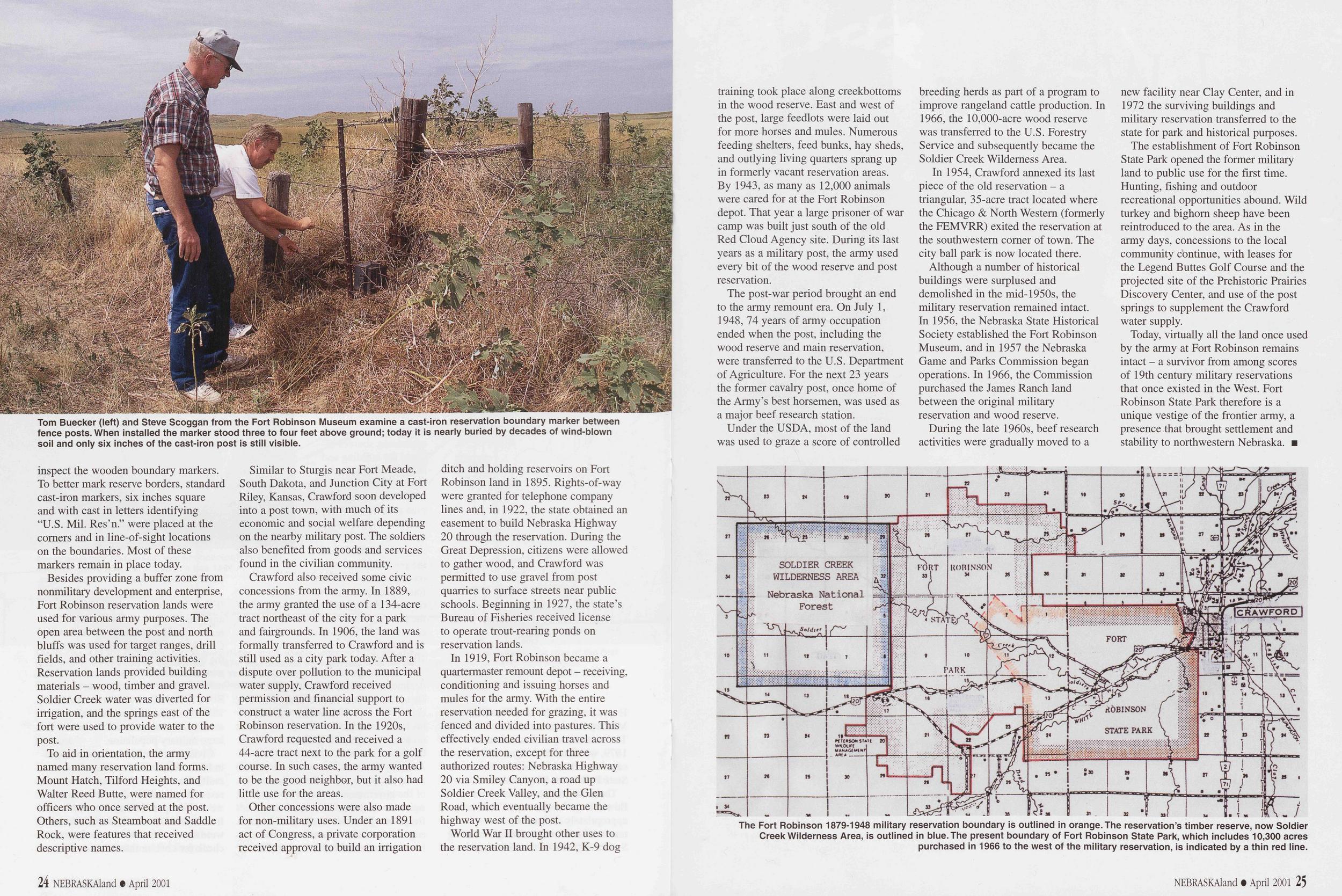
Tom Buecker (left) and Steve Scoggan from the Fort Robinson Museum examine a cast-iron reservation boundary marker between fence posts. When installed the marker stood three to four feet above ground; today it is nearly buried by decades of wind-blown soil and only six inches of the cast-iron post is still visible.
inspect the wooden boundary markers. To better mark reserve borders, standard cast-iron markers, six inches square and with cast in letters identifying “U.S. Mil. Res’n.” were placed at the comers and in line-of-sight locations on the boundaries. Most of these markers remain in place today.
Besides providing a buffer zone from nonmilitary development and enterprise, Fort Robinson reservation lands were used for various army purposes. The open area between the post and north bluffs was used for target ranges, drill fields, and other training activities. Reservation lands provided building materials - wood, timber and gravel. Soldier Creek water was diverted for irrigation, and the springs east of the fort were used to provide water to the post.
To aid in orientation, the army named many reservation land forms. Mount Hatch, Tilford Heights, and Walter Reed Butte, were named for officers who once served at the post. Others, such as Steamboat and Saddle Rock, were features that received descriptive names.
Similar to Sturgis near Fort Meade, South Dakota, and Junction City at Fort Riley, Kansas, Crawford soon developed into a post town, with much of its economic and social welfare depending on the nearby military post. The soldiers also benefited from goods and services found in the civilian community.
Crawford also received some civic concessions from the army. In 1889, the army granted the use of a 134-acre tract northeast of the city for a park and fairgrounds. In 1906, the land was formally transferred to Crawford and is still used as a city park today. After a dispute over pollution to the municipal water supply, Crawford received permission and financial support to construct a water line across the Fort Robinson reservation. In the 1920s, Crawford requested and received a 44-acre tract next to the park for a golf course. In such cases, the army wanted to be the good neighbor, but it also had little use for the areas.
Other concessions were also made for non-military uses. Under an 1891 act of Congress, a private corporation received approval to build an irrigation ditch and holding reservoirs on Fort Robinson land in 1895. Rights-of-way were granted for telephone company lines and, in 1922, the state obtained an easement to build Nebraska Highway 20 through the reservation. During the Great Depression, citizens were allowed to gather wood, and Crawford was permitted to use gravel from post quarries to surface streets near public schools. Beginning in 1927, the state’s Bureau of Fisheries received license to operate trout-rearing ponds on reservation lands.
In 1919, Fort Robinson became a quartermaster remount depot - receiving, conditioning and issuing horses and mules for the army. With the entire reservation needed for grazing, it was fenced and divided into pastures. This effectively ended civilian travel across the reservation, except for three authorized routes: Nebraska Highway 20 via Smiley Canyon, a road up Soldier Creek Valley, and the Glen Road, which eventually became the highway west of the post.
World War II brought other uses to the reservation land. In 1942, K-9 dog training took place along creekbottoms in the wood reserve. East and west of the post, large feedlots were laid out for more horses and mules. Numerous feeding shelters, feed bunks, hay sheds, and outlying living quarters sprang up in formerly vacant reservation areas. By 1943, as many as 12,000 animals were cared for at the Fort Robinson depot. That year a large prisoner of war camp was built just south of the old Red Cloud Agency site. During its last years as a military post, the army used every bit of the wood reserve and post reservation.
The post-war period brought an end to the army remount era. On July 1, 1948, 74 years of army occupation ended when the post, including the wood reserve and main reservation, were transferred to the U.S. Department of Agriculture. For the next 23 years the former cavalry post, once home of the Army’s best horsemen, was used as a major beef research station.
Under the USDA, most of the land was used to graze a score of controlled breeding herds as part of a program to improve rangeland cattle production. In 1966, the 10,000-acre wood reserve was transferred to the U.S. Forestry Service and subsequently became the Soldier Creek Wilderness Area.
In 1954, Crawford annexed its last piece of the old reservation - a triangular, 35-acre tract located where the Chicago & North Western (formerly the FEMVRR) exited the reservation at the southwestern comer of town. The city ball park is now located there.
Although a number of historical buildings were surplused and demolished in the mid-1950s, the military reservation remained intact. In 1956, the Nebraska State Historical Society established the Fort Robinson Museum, and in 1957 the Nebraska Game and Parks Commission began operations. In 1966, the Commission purchased the James Ranch land between the original military reservation and wood reserve.
During the late 1960s, beef research activities were gradually moved to a new facility near Clay Center, and in 1972 the surviving buildings and military reservation transferred to the state for park and historical purposes.
The establishment of Fort Robinson State Park opened the former military land to public use for the first time. Hunting, fishing and outdoor recreational opportunities abound. Wild turkey and bighorn sheep have been reintroduced to the area. As in the army days, concessions to the local community continue, with leases for the Legend Buttes Golf Course and the projected site of the Prehistoric Prairies Discovery Center, and use of the post springs to supplement the Crawford water supply.
Today, virtually all the land once used by the army at Fort Robinson remains intact - a survivor from among scores of 19th century military reservations that once existed in the West. Fort Robinson State Park therefore is a unique vestige of the frontier army, a presence that brought settlement and stability to northwestern Nebraska. ■
The Fort Robinson 1879-1948 military reservation boundary is outlined in orange. The reservation’s timber reserve, now Soldier Creek Wilderness Area, is outlined in blue. The present boundary of Fort Robinson State Park, which includes 10,300 acres purchased in 1966 to the west of the military reservation, is indicated by a thin red line.
Park Wonders - a Fresh View
A child's world is fresh and new and beautiful, full of wonder and excitement. It is our misfortune that for most of us that clear-eyed vision, that true instinct for what is beautiful and awe-inspiring, is dimmed and even lost before we reach adulthood. If I had influence with the good fairy who is supposed to preside over the christening of all children, I should ask her to gift each child in the world with a sense of wonder so indestructible that it would last throughout life ..."
- Rachel Carson, The Sense of Wonder
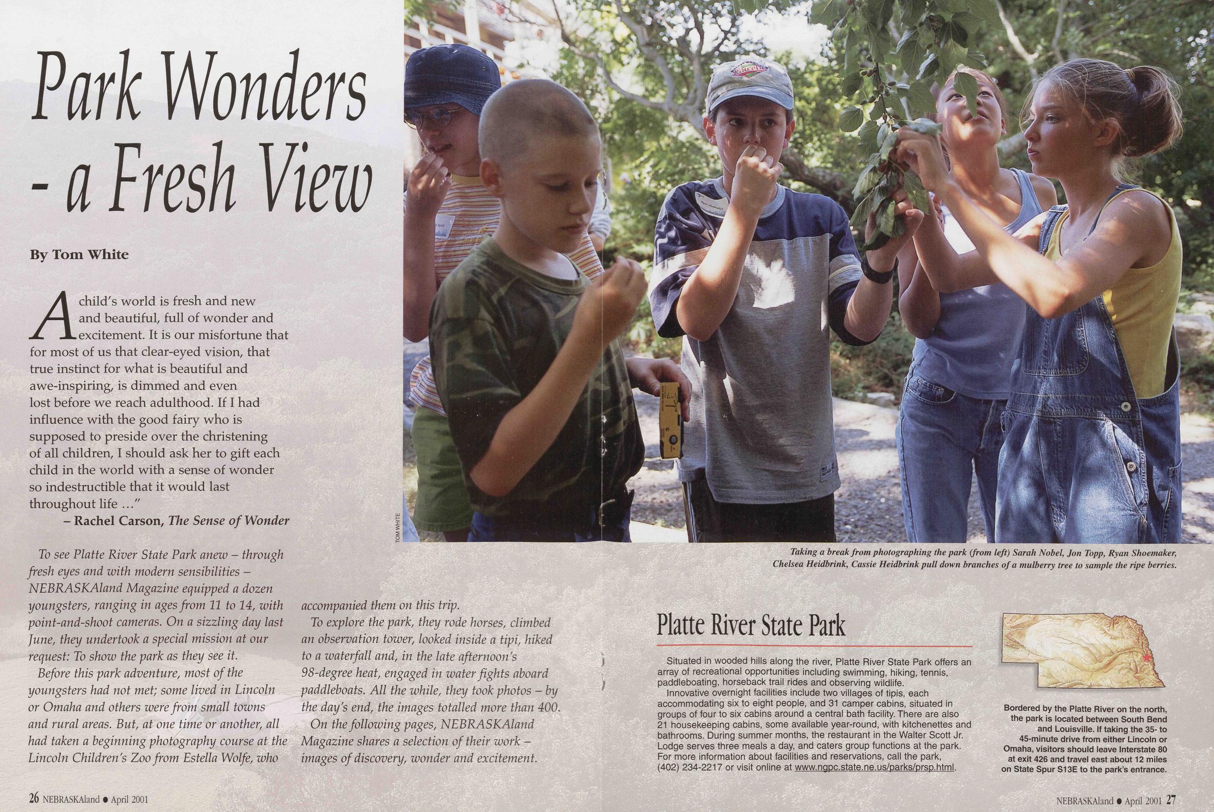
Taking a break from photographing the park (from left) Sarah Nobel, Jon Topp, Ryan Shoemaker, Chelsea Heidbrink, Cassie Heidbrink pull down branches of a mulberry tree to sample the ripe berries.
To see Platte River State Park anew - through fresh eyes and with modern sensibilities - NEBRASKAland Magazine equipped a dozen youngsters, ranging in ages from 11 to 14, with point-and-shoot cameras. On a sizzling day last June, they undertook a special mission at our request: To show the park as they see it.
Before this park adventure, most of the youngsters had not met; some lived in Lincoln or Omaha and others were from small towns and rural areas. But, at one time or another, all had taken a beginning photography course at the Lincoln Children's Zoo from Estella Wolfe, who accompanied them on this trip.
To explore the park, they rode horses, climbed an observation tower, looked inside a tipi, hiked to a waterfall and, in the late afternoon's 98-degree heat, engaged in water fights aboard paddleboats. All the while, they took photos - by the day's end, the images totalled more than 400.
On the following pages, NEBRASKAland Magazine shares a selection of their work - images of discovery, wonder and excitement.
Platte River State ParkSituated in wooded hills along the river, Platte River State Park offers an array of recreational opportunities including swimming, hiking, tennis, paddleboating, horseback trail rides and observing wildlife.
Innovative overnight facilities include two villages of tipis, each accommodating six to eight people, and 31 camper cabins, situated in groups of four to six cabins around a central bath facility. There are also 21 housekeeping cabins, some available year-round, with kitchenettes and bathrooms. During summer months, the restaurant in the Walter Scott Jr. Lodge serves three meals a day, and caters group functions at the park. For more information about facilities and reservations, call the park, (402) 234-2217 or visit online at www.napc.state.ne.us/parks/prsp.html.
Bordered by the Platte River on the north, the park is located between South Bend and Louisville. If taking the 35- to 45-minute drive from either Lincoln or Omaha, visitors should leave Interstate 80 at exit 426 and travel east about 12 miles on State Spur S13E to the park’s entrance.
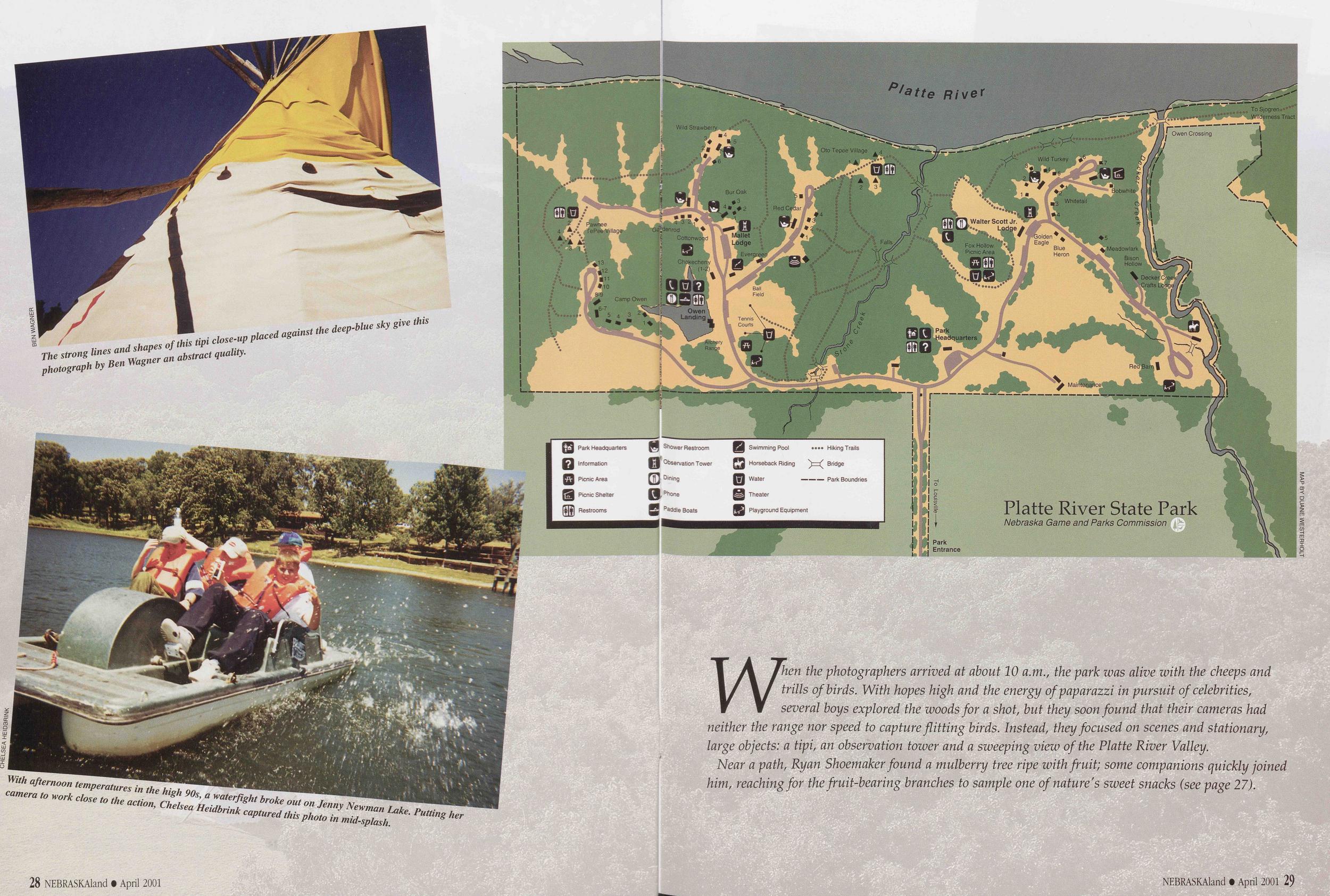
The strong lines and shapes of this tipi close-up placed against the deep-blue sky give this photograph by Ben Wagner an abstract quality.
With afternoon temperatures in the high 90s, a waterfight broke out on Jenny Newman Lake. Putting her to work close to the action, Chelsea Heidbrink captured this photo in mid-splash.
When the photographers arrived at about 10 a.m., the park was alive with the cheeps and trills of birds. With hopes high and the energy of paparazzi in pursuit of celebrities, several boys explored the woods for a shot, but they soon found that their cameras had neither the range nor speed to capture flitting birds. Instead, they focused on scenes and stationary, large objects: a tipi, an observation tower and a sweeping view of the Platte River Valley.
Near a path, Ryan Shoemaker found a mulberry tree ripe with fruit; some companions quickly joined him, reaching for the fruit-bearing branches to sample one of nature's sweet snacks (see page 27).
NEBRASKAland • April 2001 29 NEBRASKAland • April 2001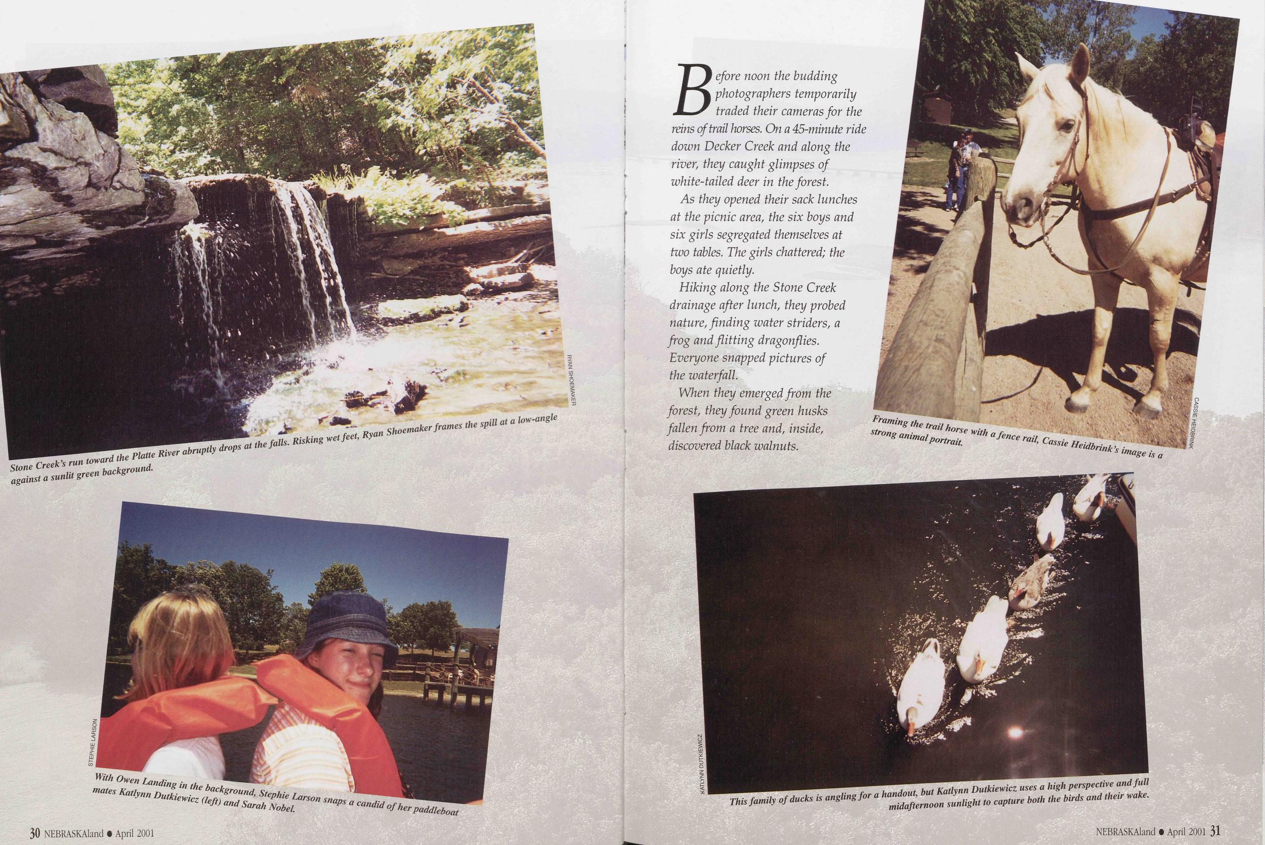
Stone Creek's run toward the Platte River abruptly drops at the falls. Risking wet feet, Ryan Shoemaker frames the spill at a low-angle against a sunlit green background.
Before noon the budding photographers temporarily traded their cameras for the reins of trail horses. On a 45-minute ride down Decker Creek and along the river, they caught glimpses of white-tailed deer in the forest.
As they opened their sack lunches at the picnic area, the six boys and six girls segregated themselves at two tables. The girls chattered; the boys ate quietly.
Hiking along the Stone Creek drainage after lunch, they probed nature, finding water striders, a frog and flitting dragonflies. Everyone snapped pictures of the waterfall.
When they emerged from the forest, they found green husks fallen from a tree and, inside, discovered black walnuts.
With Owen Landing in the background Stephie Larson snaps a mates Katlynn Dutkiewicz (left) and Sarah Nobel.
Graming the trail horse with a fence rail, Cassie Beidbrink's image is a strong animal portrait.
This family of ducks is angling for a handout, but Katlynn Dutkiewicz uses a high perspective and full midafternoon sunlight to capture both the birds and their wake.
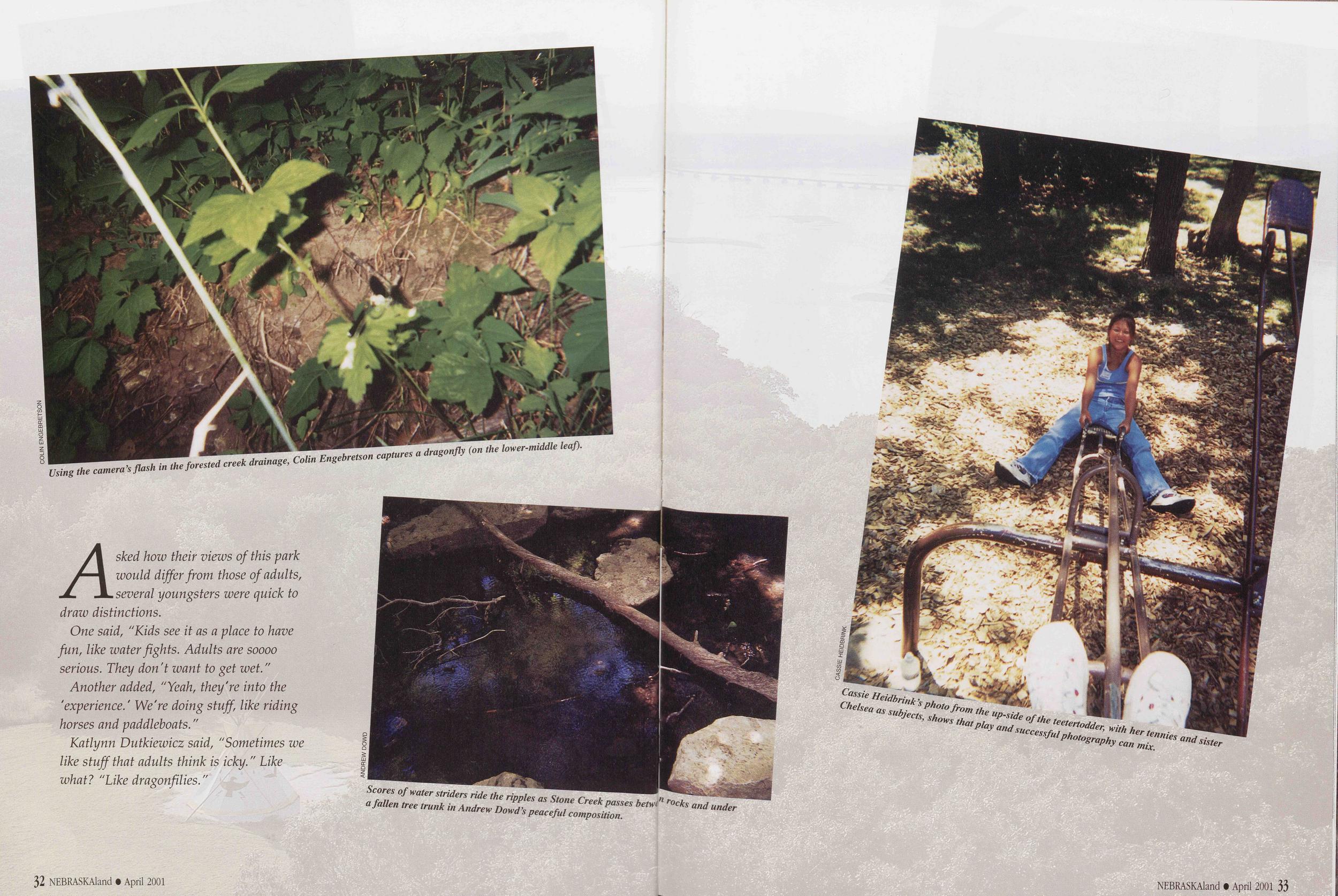
Using the camera's flash in the forested creek drainage, Colin Engebreson captures a dragonfly (on the lower-middle leaf).
Asked how their views of this park would differ from those of adults, several youngsters were quick to draw distinctions.
One said, "Kids see it as a place to have fun, like water fights. Adults are soooo serious. They don't want to get wet."
Another added, "Yeah, they're into the 'experience.' We're doing stuff, like riding horses and paddleboats."
Katlynn Dutkiewicz said, "Sometimes we like stuff that adults think is icky." Like what? "Like dragonfilies."
Scores of water striders ride the ripples as Stone Creek passes betwd1 rocks and under a fallen tree trunk in Andrew Dowd’s peaceful composition.
Cassie Heidbrink’s photo from the up-side of the teetertodder, with her tennies and sister Chelsea as subjects, shows that play and successful photography can mix.
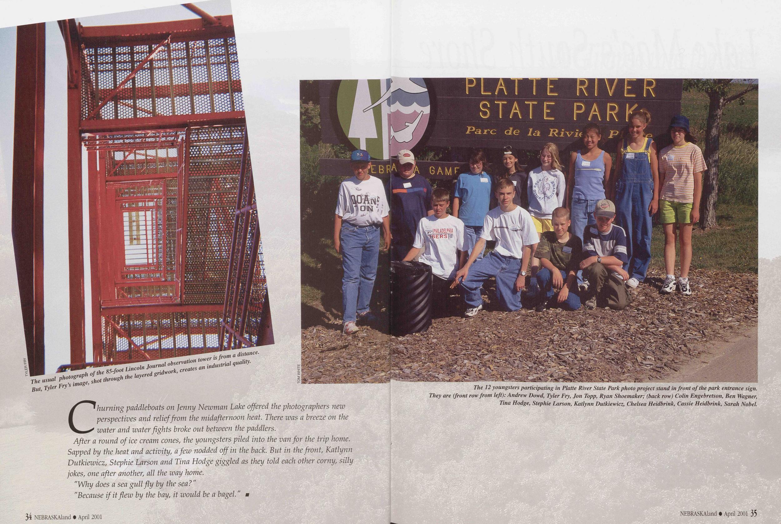
The 12 youngsters participating in Platte River State Park photo project stand in front of the park entrance sign. They are (front row from left): Andrew Dowd, Tyler Fry, Jon Topp, Ryan Shoemaker; (back row) Colin Engebretson, Ben Wagner, Tina Hodge, Stephie Larson, Katlynn Dutkiewicz, Chelsea Heidbrink, Cassie Heidbrink, Sarah Nobel.
The usual photograph of the 85-foot Lincoln Journal observation tower is from a distance. But, Tyler Fry’s image, shot through the layered gridwork, creates an industrial quality.
Churning paddleboats on Jenny Newman Lake offered the photographers new perspectives and relief from the midafternoon heat. There was a breeze on the water and water fights broke out between the paddlers.
After a round of ice cream cones, the youngsters piled into the van for the trip home. Sapped by the heat and activity, a few nodded off in the back. But in the front, Katlynn Dutkiewicz, Stephie Larson and Tina Hodge giggled as they told each other corny, silly jokes, one after another, all the way home.
"Why does a sea gull fly by the sea?"
"Because if it flew by the bay, it would be a bagel."
34 NEBRASKAland • April 2001 NEBRASKAland • April 2001 35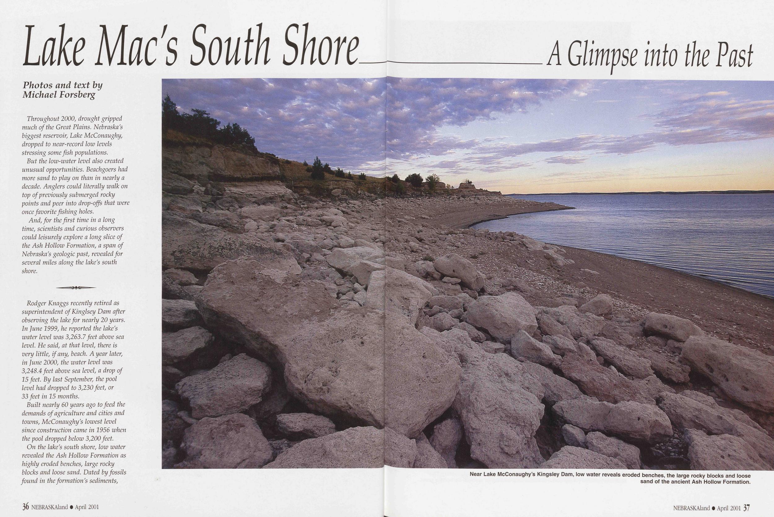
Lake Mac's South Shore
A Glimpse into the Past
Throughout 2000, drought gripped much of the Great Plains. Nebraska's biggest reservoir; Lake McConaughy, dropped to near-record low levels stressing some fish populations.
But the low-water level also created unusual opportunities. Beachgoers had more sand to play on than in nearly a decade. Anglers could literally walk on top of previously submerged rocky points and peer into drop-offs that were once favorite fishing holes.
And, for the first time in a long time, scientists and curious observers could leisurely explore a long slice of the Ash Hollow Formation, a span of Nebraska's geologic past, revealed for several miles along the lake's south shore.
Rodger Knaggs recently retired as superintendent of Kinglsey Dam after observing the lake for nearly 20 years. In June 1999z he reported the lake's water level was 3,263.7 feet above sea level. He said, at that level, there is very little, if any, beach. A year later, in June 2000, the water level was 3,248.4 feet above sea level, a drop of 15 feet. By last September, the pool level had dropped to 3,230feet, or 33 feet in 15 months.
Built nearly 60 years ago to feed the demands of agriculture and cities and towns, McConaughy's lowest level since construction came in 1956 when the pool dropped below 3,200 feet. On the lake's south shore, low water revealed the Ash Hollow Formation as highly eroded benches, large rocky blocks and loose sand. Dated by fossils found in the formation's sediments,
Near Lake McConaughy’s Kingsley Dam, low water reveals eroded benches, the large rocky blocks and loose sand of the ancient Ash Hollow Formation.
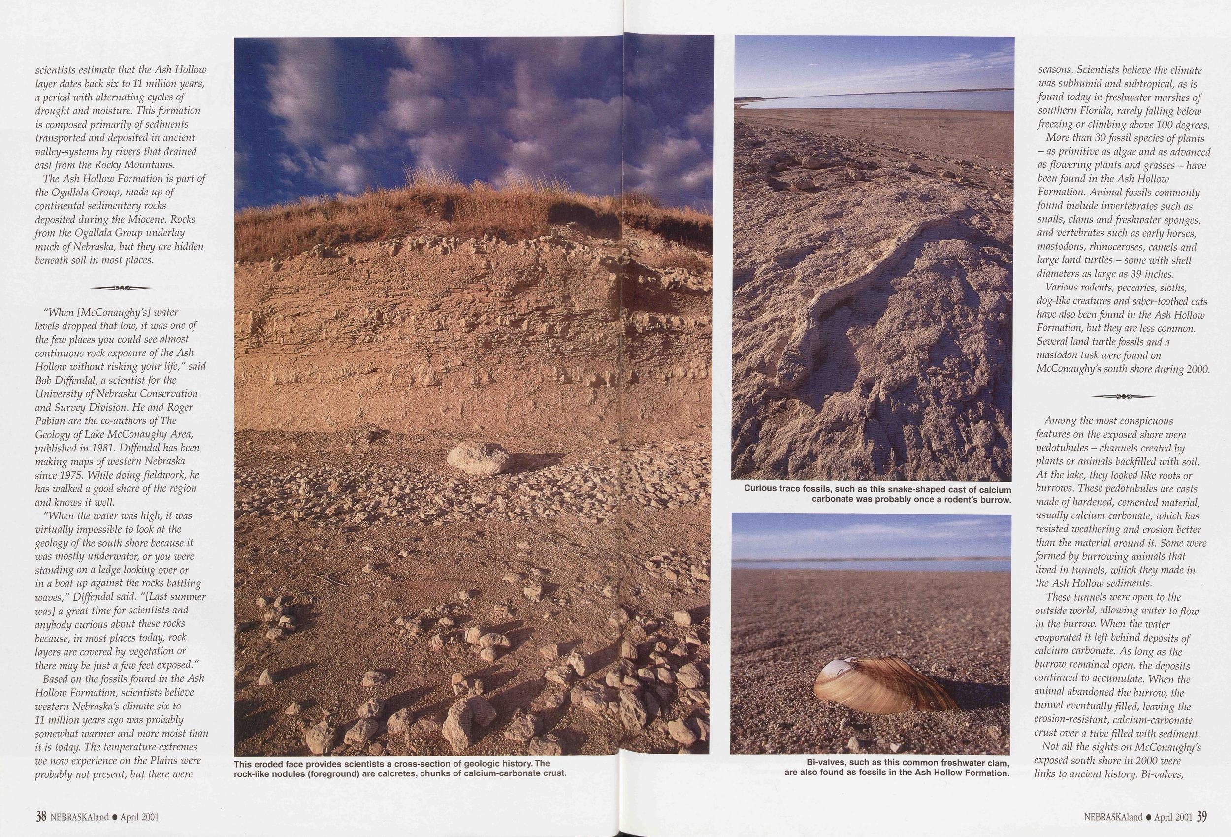
scientists estimate that the Ash Hollow layer dates back six to 11 million years, a period with alternating cycles of drought and moisture. This formation is composed primarily of sediments transported and deposited in ancient valley-systems by rivers that drained east from the Rocky Mountains.
The Ash Hollow Formation is part of the Ogallala Group, made up of continental sedimentary rocks deposited during the Miocene. Rocks from the Ogallala Group underlay much of Nebraska, but they are hidden beneath soil in most places.
"When [McConaughy's] water levels dropped that low, it was one of the few places you could see almost continuous rock exposure of the Ash Hollow without risking your life," said Bob Diffendal, a scientist for the University of Nebraska Conservation and Survey Division. He and Roger Pabian are the co-authors of The Geology of Lake McConaughy Area, published in 1981. Diffendal has been making maps of western Nebraska since 1975. While doing fieldwork, he has walked a good share of the region and knows it well.
"When the water was high, it was virtually impossible to look at the geology of the south shore because it was mostly underwater, or you were standing on a ledge looking over or in a boat up against the rocks battling waves," Diffendal said. "[Last summer was] a great time for scientists and anybody curious about these rocks because, in most places today, rock layers are covered by vegetation or there may be just a few feet exposed."
Based on the fossils found in the Ash Hollow Formation, scientists believe western Nebraska's climate six to 11 million years ago was probably somewhat warmer and more moist than it is today. The temperature extremes we now experience on the Plains were probably not present, but there were
This eroded face provides scientists a cross-section of geologic history. The rock-iike nodules (foreground) are calcretes, chunks of calcium-carbonate crust.
Curious trace fossils, such as this snake-shaped cast of calcium carbonate was probably once a rodent’s burrow.
Bi-valves, such as this common freshwater clam, are also found as fossils in the Ash Hollow Formation.
seasons. Scientists believe the climate was subhumid and subtropical, as is found today in freshwater marshes of southern Florida, rarely falling below freezing or climbing above 100 degrees.
More than 30 fossil species of plants - as primitive as algae and as advanced as flowering plants and grasses - have been found in the Ash Hollow Formation. Animal fossils commonly found include invertebrates such as snails, clams and freshwater sponges, and vertebrates such as early horses, mastodons, rhinoceroses, camels and large land turtles - some with shell diameters as large as 39 inches.
Various rodents, peccaries, sloths, dog-like creatures and saber-toothed cats have also been found in the Ash Hollow Formation, but they are less common. Several land turtle fossils and a mastodon tusk were found on McConaughy's south shore during 2000.
Among the most conspicuous features on the exposed shore were pedotubules - channels created by plants or animals backfilled with soil. At the lake, they looked like roots or burrows. These pedotubules are casts made of hardened, cemented material, usually calcium carbonate, which has resisted weathering and erosion better than the material around it. Some were formed by burrowing animals that lived in tunnels, which they made in the Ash Hollow sediments.
These tunnels were open to the outside world, allowing water to flow in the burrow. When the water evaporated it left behind deposits of calcium carbonate. As long as the burrow remained open, the deposits continued to accumulate. When the animal abandoned the burrow, the tunnel eventually filled, leaving the erosion-resistant, calcium-carbonate crust over a tube filled with sediment. Not all the sights on McConaughy's exposed south shore in 2000 were links to ancient history. Bi-valves,
38 NEBRASKAland • April 2001 NEBRASKAland • April 2001 39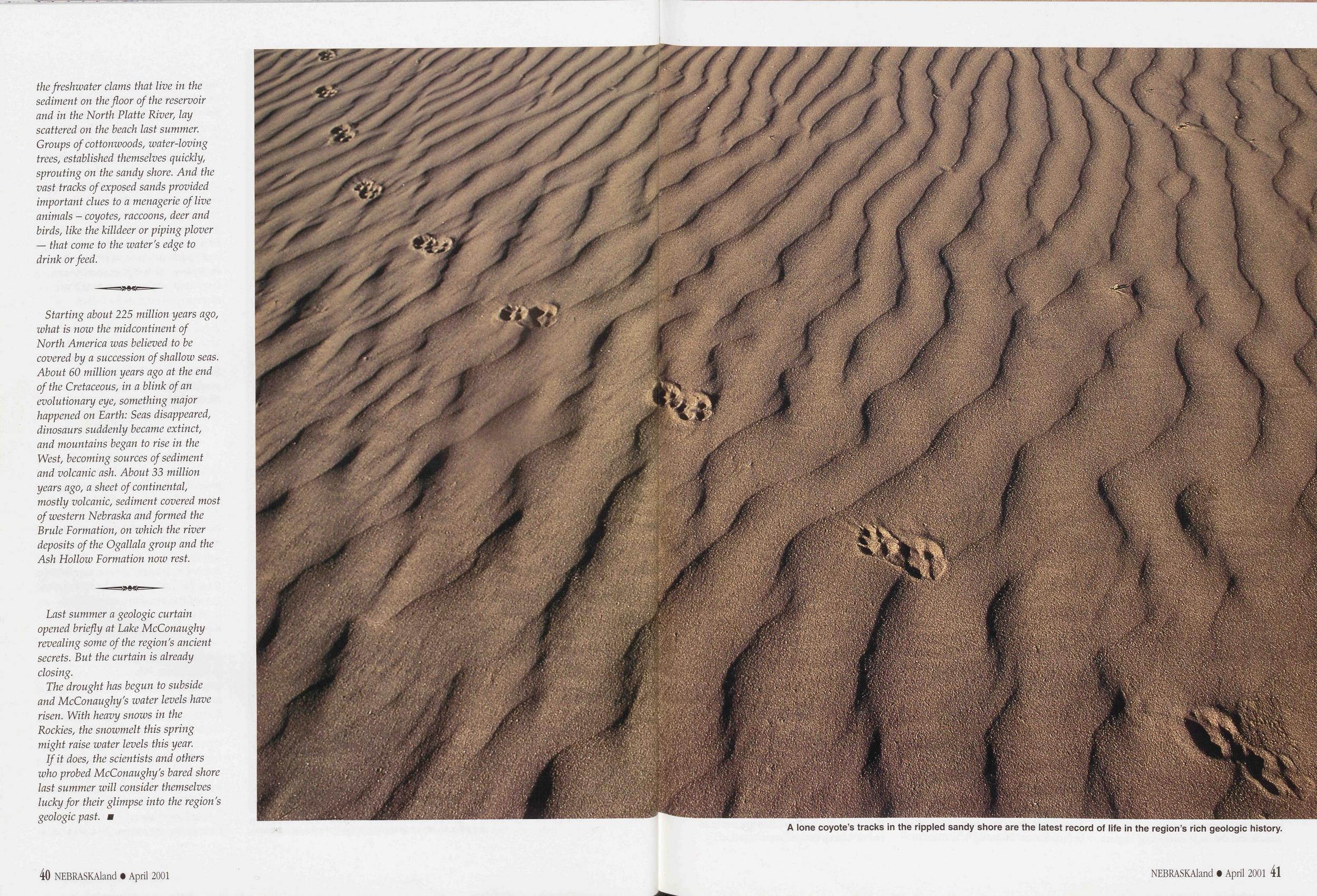
the freshwater clams that live in the sediment on the floor of the reservoir and in the North Platte River, lay scattered on the beach last summer. Groups of cottonwoods, water-loving trees, established themselves quickly, sprouting on the sandy shore. And the vast tracks of exposed sands provided important clues to a menagerie of live animals - coyotes, raccoons, deer and birds, like the killdeer or piping plover — that come to the water's edge to drink or feed.
Starting about 225 million years ago, what is now the midcontinent of North America was believed to be covered by a succession of shallow seas. About 60 million years ago at the end of the Cretaceous, in a blink of an evolutionary eye, something major happened on Earth: Seas disappeared, dinosaurs suddenly became extinct, and mountains began to rise in the West, becoming sources of sediment and volcanic ash. About 33 million years ago, a sheet of continental, mostly volcanic, sediment covered most of western Nebraska and formed the Brule Formation, on which the river deposits of the Ogallala group and the Ash Hollow Formation now rest.
Last summer a geologic curtain opened briefly at Lake McConaughy revealing some of the region's ancient secrets. But the curtain is already closing.
The drought has begun to subside and McConaughy's water levels have risen. With heavy snows in the Rockies, the snowmelt this spring might raise water levels this year.
If it does, the scientists and others who probed McConaughy's bared shore last summer will consider themselves lucky for their glimpse into the region's geologic past.
A lone coyote's tracks in the rippled sandy short are the latest record of life in the region's rich geologic history.
Lake Minatare a surprising discovery
At first, fishing in this wide spot of an old irrigation system doesn’t appear promising, but look again. Careful forage fish management and newly constructed reefs - adding structure and habitat - have turned this 2,158-acre reservoir into a promising Panhandle fishery.A Colorado angler overheard fishermen in a store talking about great walleye fishing in the Panhandle. But, because he didn’t remember the name of the lake, he called Jack Peterson, district fisheries supervisor at the Nebraska Game and Parks Commission office in Alliance.
Peterson, who regularly handles requests for fishing information, told the caller the lake could be Lake Minatare. The next afternoon, Peterson unexpectedly got another call from the same fisherman. This time, he wanted to report his success.
“He said they towed their boat to Minatare that morning and found anglers with limits of walleyes loading their boats. In the distance they saw a group of boats on the lake and fishermen landing fish. He said both of them were back at the dock within an hour with their limits of walleyes.”
Fishing was exceptional that morning - one of those rare times anglers remember well and retell often - but, it was not unique. In recent years, Lake Minatare has developed a surprising reputation for success among anglers.
It’s especially surprising given the lake’s almost featureless sandy shoreline and bottom, its severe drawdown during the summer irrigation season and the large number of anglers who are attracted to the only sizeable reservoir in the central Panhandle. With 2,158 surface acres when full, Lake Minatare supports a multi-species fishery, including walleye, channel catfish, crappie, yellow perch, wiper, smallmouth bass and white bass.
Minatare was built as an irrigation reservoir in 1915, part of a system known as the “inland lakes,” which includes three other lakes and water-delivery canals. Essentially a wide spot in the water-delivery system, Minatare is a highly productive fishery despite the heavy irrigation drawdowns from it. Its water turnover rate is one of the fastest in the state. From May, when the lake is full, to the end of the irrigation season in late-September, Minatare loses an average of 52 percent of its water volume. Other Nebraska reservoirs might take three years or more for outflows to exceed their storage capacities.
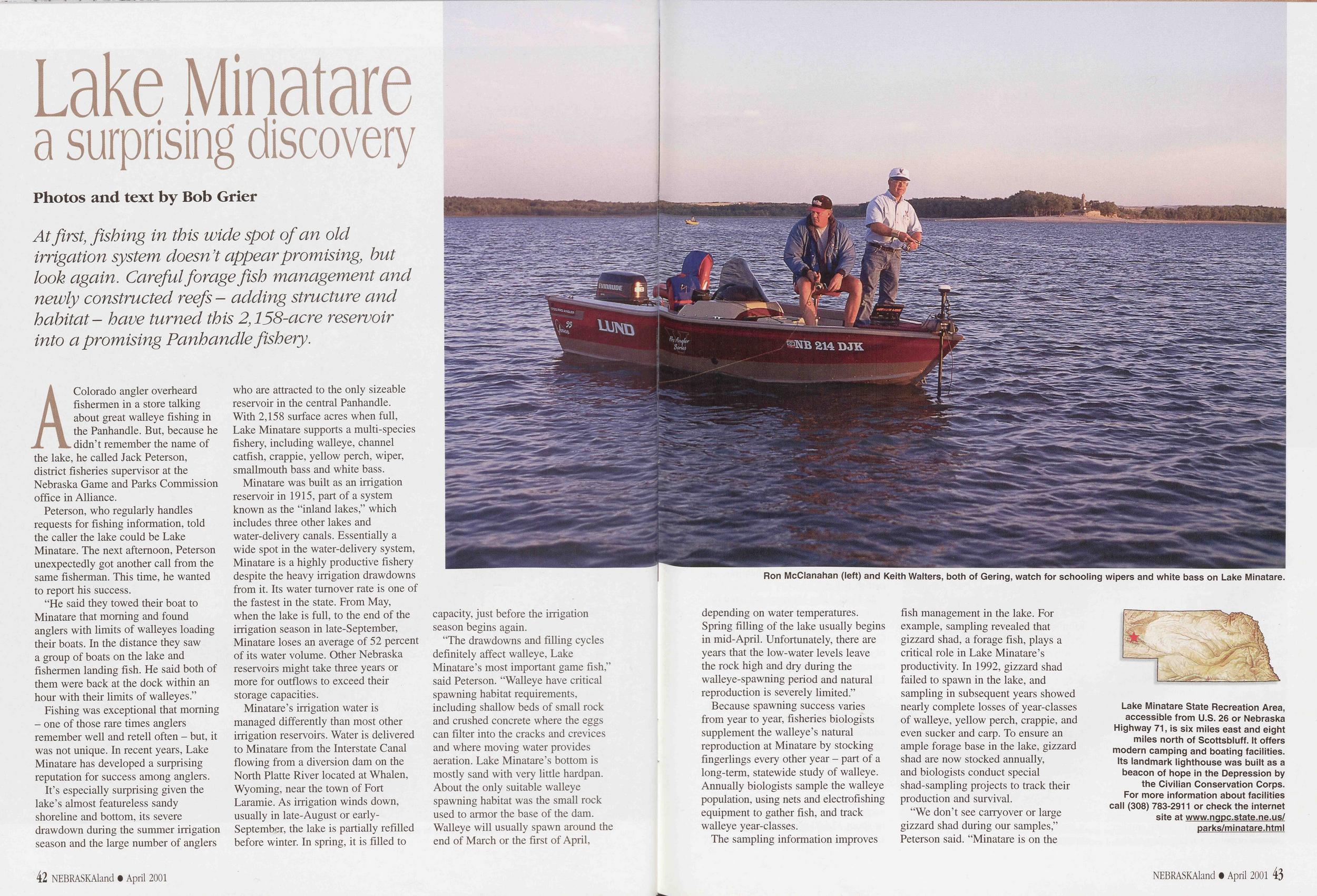
Ron McClanahan (left) and Keith Walters, both of Gering, watch for schooling wipers and white bass on Lake Minatare.
“The drawdowns and filling cycles definitely affect walleye, Lake Minatare’s most important game fish,” said Peterson. “Walleye have critical spawning habitat requirements, including shallow beds of small rock and crushed concrete where the eggs can filter into the cracks and crevices and where moving water provides aeration. Lake Minatare’s bottom is mostly sand with very little hardpan. About the only suitable walleye spawning habitat was the small rock used to armor the base of the dam. Walleye will usually spawn around the end of March or the first of April, depending on water temperatures. Spring filling of the lake usually begins in mid-April. Unfortunately, there are years that the low-water levels leave the rock high and dry during the walleye-spawning period and natural reproduction is severely limited.”
Because spawning success varies from year to year, fisheries biologists supplement the walleye’s natural reproduction at Minatare by stocking fingerlings every other year - part of a long-term, statewide study of walleye. Annually biologists sample the walleye population, using nets and electrofishing equipment to gather fish, and track walleye year-classes.
The sampling information improves fish management in the lake. For example, sampling revealed that gizzard shad, a forage fish, plays a critical role in Lake Minatare’s productivity. In 1992, gizzard shad failed to spawn in the lake, and sampling in subsequent years showed nearly complete losses of year-classes of walleye, yellow perch, crappie, and even sucker and carp. To ensure an ample forage base in the lake, gizzard shad are now stocked annually, and biologists conduct special shad-sampling projects to track their production and survival.
“We don’t see carryover or large gizzard shad during our samples,” Peterson said. “Minatare is on the
Lake Minatare State Recreation Area, accessible from U.S. 26 or Nebraska Highway 71, is six miles east and eight miles north of Scottsbluff. It offers modern camping and boating facilities. Its landmark lighthouse was built as a beacon of hope in the Depression by the Civilian Conservation Corps. For more information about facilities call (308) 783-2911 or check the internet site at www.ngpc.state.ne.us/ parks/minatare.html

Biologists Al Hanson (left) and Jack Peterson mark, record and determine the sex of each walleye they collect during a study to find out how many fish use new Minatare reefs and windrows. This unusual nighttime photo was taken using a four-second exposure followed by a flash. What appear to be flames are spotlights located behind the biologists (who moved during the exposure) and reflections off the water in the tub. The walleye was caught in midair by the flash after being tossed toward the lake.
northern edge of the gizzard shad’s range, and our concern is high winter mortality. The supplemental stocking of adult gizzard shad in the reservoir is kind of an insurance policy. We seine shad from ten different locations in the lake each summer and check the size of young-of-the-year fish as part of the on-going walleye study. Our fall sampling finds very few shad survive to age one or two. We also use graph-recording sonar to provide additional information on schooling shad, not only the numbers of schools but the size of the schools help to identify the lake’s shad base going into the fall, winter and spring.
“We also find an emerald shiner presence in Minatare, probably from upstream stockings in Wyoming reservoirs on the North Platte River. The emerald shiners don’t appear to have a detrimental effect at this time, but they are predators for the smaller aquatic organisms that young-of-the- year game fish require.”
Lake Minatare’s forage base creates a fast-growing walleye population; they reach 7.4 inches at the end of their first year, 13.2 inches by the next year and 16.5 inches by the end of the third growing season. The average four-year- old walleye is 18.6 inches. Minatare samples show very few walleyes exceeding 20 inches - probably because of fishing pressure. What is certain is that walleyes exceeding the 15-inch keeper minimum are extremely popular with anglers.
The forage base also supports limited stocking of wiper, a tackle-busting hybrid of the striped bass and white bass. Minatare receives a small number of stocked wipers - 5 per acre, or about 10,000 wipers - every other year.
Peterson believes the wipers offer a bonus trophy fish to Minatare anglers. Recent sampling indicates Minatare has a larger than normal year-class of wipers exceeding five pounds - a fact that should mean good or excellent wiper fishing for the next several years. Anglers are also taking increasing numbers of smallmouth bass and the lake has an underutilized channel catfish fishery.
In 1998, Lake Minatare received the first major aquatic-habitat construction project in Nebraska’s Panhandle. Contractors laid down nearly 8,600 tons of crushed concrete and cobble rock, creating aquatic reefs along the lake’s Lighthouse Point and dam.
Funded by the Aquatic Habitat Stamp program and Nebraska Environmental Trust grants, the project provided additional structure and habitat for spawning walleyes and other fish species, and for organisms in the aquatic food chain.
Two reefs, separated by a 100-foot buffer, were built below the lighthouse, each 176 feet long and 213 feet wide, or about 37,500 square feet. Broken concrete was used to form the north reef; the south reef was constructed of cobble rock - gravel two to six inches in diameter - excavated nearby.
The location, dimensions and elevation of the aquatic reefs were designed with Lake Minatare’s changing water levels in mind.
“The lake’s water elevation usually varies almost 20 vertical feet during the irrigation season,” Peterson said. “The sites and elevations selected ensures that rock will be available as the reservoir’s water levels rise and fall. Using both crushed concrete and cobble rock reefs gave us the opportunity to evaluate their use by spawning walleye for future habitat improvement projects.”
In addition to the reefs, contractors created triangle-shaped windrows of cobble rock, VA foot high on a 4A- to five-foot base, around the tip of Lighthouse Point. Totaling 7,230 feet in length, the 48 windrows are separated by five-foot gaps. They provide aquatic habitat for fish, invertebrates and other organisms.
Cobble rock was also placed along the dam during the fall when the lake was down. The windrows and aquatic reefs are marked with buoys to alert boaters to the presence of underwater structures.
Peterson and Al Hanson, also a Commission biologist, sampled walleye during the 2000 spawning period to determine their use of the new reefs and windrows. The biologists used electrofishing equipment mounted on a boat to temporarily stun fish in an area so they could be collected. The sampling was done during three nights in April, approximately a week apart.
Each night the researchers began sampling at sundown, spending equal time on each reef and nearby control areas. Several electrofishing passes were made over each area. All the captured walleye were transported away from the study area and marked to identify those recaptured later. The researchers also determined and recorded the sex of each fish.
During the three nights of sampling, the number of walleyes collected on the aquatic reefs totaled 868, of which 73 were recaptures. They collected 524 walleyes, or 60 percent of the total, over the cobble reef, and 344 fish, or 40 percent, from the crushed concrete reef.
Near Lighthouse Point, a broken concrete aquatic reef, which offers spawning habitat for walleyes in spring, was completed before Lake Minatare’s water level rose in the fall.
The recent aquatic reef projects at Lake Minatare have provided important submerged structure and habitat for game fish and other aquatic organisms. For the future, these projects and on-going efforts to assure an ample forage base should provide Nebraska Panhandle anglers excellent fishing opportunities and enhance Lake Minatare’s reputation as a surprising fishery. ■
44 NEBRASKAland • April 2001 NEBRASKAland • April 2001 45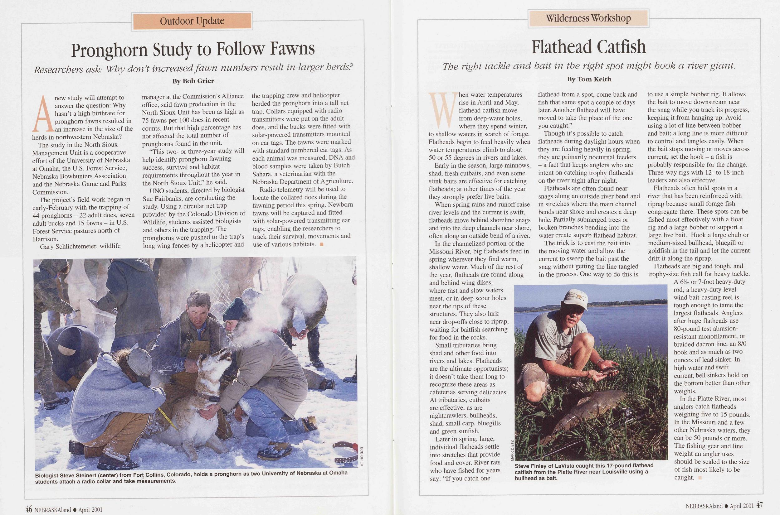
Outdoor Update
Pronghorn Study to Follow Fawns
Researchers ask: Why don’t increased fawn numbers result in larger herds?
A new study will attempt to answer the question: Why hasn’t a high birthrate for pronghorn fawns resulted in an increase in the size of the herds in northwestern Nebraska?
The study in the North Sioux Management Unit is a cooperative effort of the University of Nebraska at Omaha, the U.S. Forest Service, Nebraska Bowhunters Association and the Nebraska Game and Parks Commission.
The project’s field work began in early-February with the trapping of 44 pronghorns - 22 adult does, seven adult bucks and 15 fawns - in U.S. Forest Service pastures north of Harrison.
Biologist Steve Steinert (center) from Fort Collins, Colorado, holds a pronghorn as two University of Nebraska at Omaha students attach a radio collar and take measurements.
BOB GRIER"This two- or three-year study will help identify pronghorn fawning success, survival and habitat requirements throughout the year in the North Sioux Unit,” he said.
UNO students, directed by biologist Sue Fairbanks, are conducting the study. Using a circular net trap provided by the Colorado Division of Wildlife, students assisted biologists and others in the trapping. The pronghorns were pushed to the trap’s long wing fences by a helicopter and the trapping crew and helicopter herded the pronghorn into a tall net trap. Collars equipped with radio transmitters were put on the adult does, and the bucks were fitted with solar-powered transmitters mounted on ear tags. The fawns were marked with standard numbered ear tags. As each animal was measured, DNA and blood samples were taken by Butch Sahara, a veterinarian with the Nebraska Department of Agriculture.
Radio telemetry will be used to locate the collared does during the fawning period this spring. Newborn fawns will be captured and fitted with solar-powered transmitting ear tags, enabling the researchers to track their survival, movements and use of various habitats. ■
Wilderness Workshop
Flathead Catfish
The right tackle and bait in the right spot might hook a river giant.
When water temperatures rise in April and May, flathead catfish move from deep-water holes, where they spend winter, to shallow waters in search of forage. Flatheads begin to feed heavily when water temperatures climb to about 50 or 55 degrees in rivers and lakes.
Early in the season, large minnows, shad, fresh cutbaits, and even some stink baits are effective for catching flatheads; at other times of the year they strongly prefer live baits.
When spring rains and runoff raise river levels and the current is swift, flatheads move behind shoreline snags and into the deep channels near shore, often along an outside bend of a river.
In the channelized portion of the Missouri River, big flatheads feed in spring wherever they find warm, shallow water. Much of the rest of the year, flatheads are found along and behind wing dikes, where fast and slow waters meet, or in deep scour holes near the tips of these structures. They also lurk near drop-offs close to riprap, waiting for baitfish searching for food in the rocks.
Small tributaries bring shad and other food into rivers and lakes. Flatheads are the ultimate opportunists; it doesn’t take them long to recognize these areas as cafeterias serving delicacies. At tributaries, cutbaits are effective, as are nightcrawlers, bullheads, shad, small carp, bluegills and green sunfish.
Later in spring, large, individual flatheads settle into stretches that provide food and cover. River rats who have fished for years say: “If you catch one flathead from a spot, come back and fish that same spot a couple of days later. Another flathead will have moved to take the place of the one you caught.”
Though it’s possible to catch flatheads during daylight hours when they are feeding heavily in spring, they are primarily nocturnal feeders - a fact that keeps anglers who are intent on catching trophy flatheads on the river night after night.
Flatheads are often found near snags along an outside river bend and in stretches where the main channel bends near shore and creates a deep hole. Partially submerged trees or broken branches bending into the water create superb flathead habitat.
Steve Finley of LaVista caught this 17-pound flathead catfish from the Platte River near Louisville using a bullhead as bait.
Flatheads often hold spots in a river that has been reinforced with riprap because small forage fish congregate there. These spots can be fished most effectively with a float rig and a large bobber to support a large live bait. Hook a large chub or medium-sized bullhead, bluegill or goldfish in the tail and let the current drift it along the riprap.
Flatheads are big and tough, and trophy-size fish call for heavy tackle. A 6 A- or 7-foot heavy-duty rod, a heavy-duty level wind bait-casting reel is tough enough to tame the largest flatheads. Anglers after huge flatheads use 80-pound test abrasion- resistant monofilament, or braided dacron line, an 8/0 hook and as much as two ounces of lead sinker. In high water and swift current, bell sinkers hold on the bottom better than other weights.
In the Platte River, most anglers catch flatheads weighing five to 15 pounds. In the Missouri and a few other Nebraska waters, they can be 50 pounds or more. The fishing gear and line weight an angler uses should be scaled to the size of fish most likely to be caught.
46 NEBRASKAland • April 2001 NEBRASKAland • April 2001 47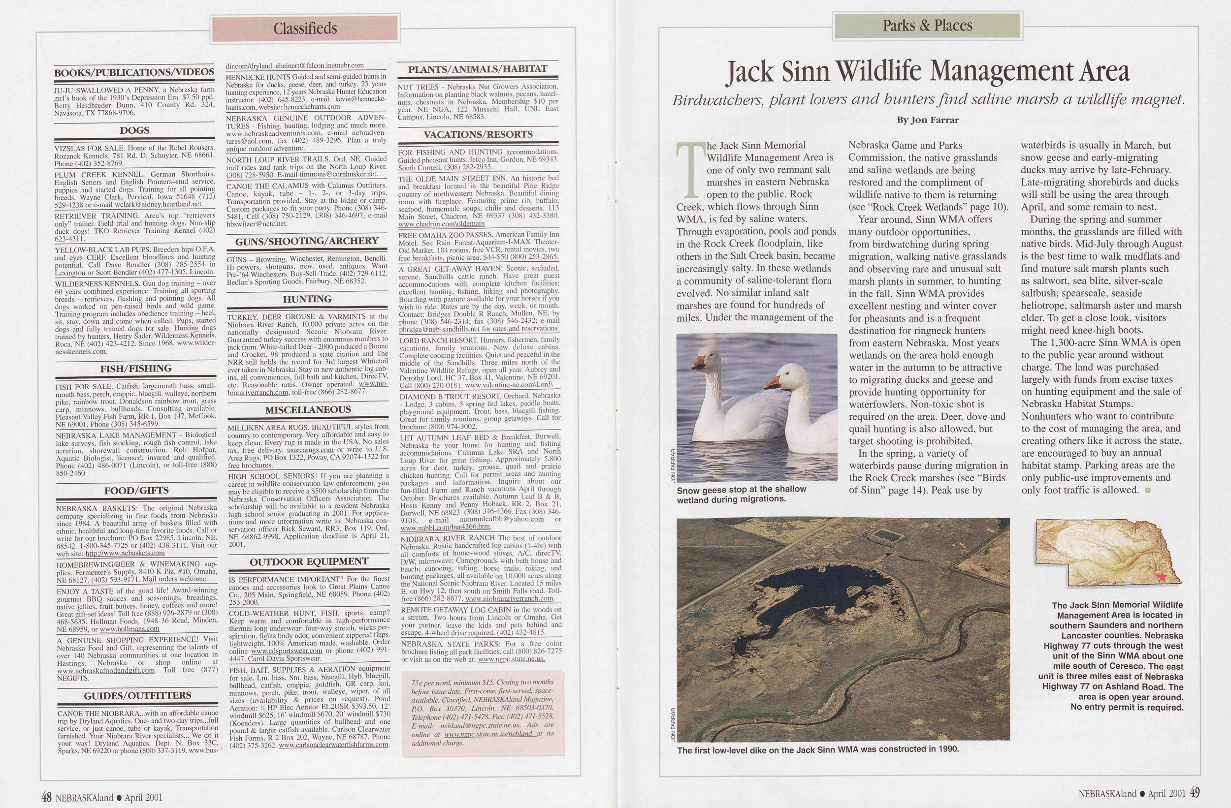
Classifieds
Parks & Places BOOKS/PUBLICATION S/VIDEOS JU-JU SWALLOWED A PENNY, a Nebraska farm girl’s book of the 1930’s Depression Era. $7.50 ppd. Betty Heidbreder Dunn, 410 County Rd. 324, Navasota, TX 77868-9706. DOGS VIZSLAS FOR SALE. Home of the Rebel Rousers. Rozanek Kennels, 781 Rd. D, Schuyler, NE 68661. Phone (402) 352-8769. PLUM CREEK KENNEL. German Shorthairs, English Setters and English Pointers-stud service, puppies and started dogs. Training for all pointing breeds. Wayne Clark, Pervical, Iowa 51648 (712) 529-4238 or e-mail wclark@sidney.heartland.net. RETRIEVER TRAINING. Area’s top “retrievers only” trainer. Field trial and hunting dogs. Non-slip duck dogs! TKO Retriever Training Kennel (402) 623-4311. YELLOW-BLACK LAB PUPS. Breeders hips O.F.A. and eyes CERF. Excellent bloodlines and hunting potential. Call Dave Bendler (308) 785-2554 in Lexington or Scott Bendler (402) 477-1305, Lincoln. WILDERNESS KENNELS. Gun dog training - over 60 years combined experience. Training all sporting breeds - retrievers, flushing and pointing dogs. All dogs worked on pen-raised birds and wild game. Training program includes obedience training - heel, sit, stay, down and come when called. Pups, started dogs and fully trained dogs for sale. Hunting dogs trained by hunters. Henry Sader, Wilderness Kennels, Roca, NE (402) 423-4212. Since 1968. www.wilder- nesskennels.com. FISH/FISHING FISH FOR SALE. Catfish, largemouth bass, small- mouth bass, perch, crappie, bluegill, walleye, northern pike, rainbow trout, Donaldson rainbow trout, grass carp, minnows, bullheads. Consulting available. Pleasant Valley Fish Farm, RR 1, Box 147, McCook, NE 69001. Phone (308) 345-6599. NEBRASKA LAKE MANAGEMENT - Biological lake surveys, fish stocking, rough fish control, lake aeration, shorewall construction. Rob Hofpar, Aquatic Biologist, licensed, insured and qualified. Phone (402) 486-0071 (Lincoln), or toll-free (888) 850-2460. FOOD/GIFTS NEBRASKA BASKETS: The original Nebraska company specializing in fine foods from Nebraska since 1984. A beautiful array of baskets filled with ethnic, healthful and long-time favorite foods. Call or write for our brochure: PO Box 22985, Lincoln, NE. 68542. 1-800-345-7725 or (402) 438-3111. Visit our web site: http://www.nebaskets.com HOMEBREWING/BEER & WINEMAKING sup- plies. Fermenter’s Supply, 8410 K Plz. #10, Omaha, NE 68127. (402) 593-9171. Mail orders welcome. ENJOY A TASTE of the good life! Award-winning gourmet BBQ sauces and seasonings, breadings, native jellies, fruit butters, honey, coffees and more! Great gift-set ideas! Toll free (888) 926-2879 or (308) 468-5635. Hollman Foods, 1948 36 Road, Minden, NE 68959, or www.hollmans.com A GENUINE SHOPPING EXPERIENCE! Visit Nebraska Food and Gift, representing the talents of over 140 Nebraska communities at one location in Hastings, Nebraska or shop online at www.nebraskafoodandgift.com. Toll free (877) NEGIFTS. GUIDES/OUTFITTERS CANOE THE NIOBRARA...with an affordable canoe trip by Dryland Aquatics. One- and two-day trips...full service, or just canoe, tube or kayak. Transportation furnished. Your Niobrara River specialists... We do it your way! Dryland Aquatics, Dept. N, Box 33C, Sparks, NE 69220 or phone (800) 337-3119. www.bus- dir.com/dryland. eheinert@falcon.inetnebr.com HENNECKE HUNTS Guided and semi-guided hunts in Nebraska for ducks, geese, deer, and turkey. 25 years hunting experience, 12 years Nebraska Hunter Education instructor. (402) 645-8223, e-mail: kevin@hennecke- hunts.com, website: henneckehunts.com NEBRASKA GENUINE OUTDOOR ADVEN- TURES - Fishing, hunting, lodging and much more. www.nebraskaadventures.com, e-mail nebradven- tures@aol.com, fax (402) 489-3296. Plan a truly unique outdoor adventure. NORTH LOUP RIVER TRAILS, Ord, NE. Guided trail rides and tank trips on the North Loup River. (308) 728-5950. E-mail timmons@cornhusker.net. CANOE THE CALAMUS with Calamus Outfitters. Canoe, kayak, tube - 1-, 2-, or 3-day trips. Transportation provided. Stay at the lodge or camp. Custom packages to fit your party. Phone (308) 346- 5481, Cell (308) 750-2129, (308) 346-4697, e-mail hbs witzer @ nctc. net. GUNS/SHOOTING/ARCHERY GUNS - Browning, Winchester, Remington, Benelli. Hi-powers, shotguns, new, used, antiques. Want Pre-'64 Winchesters. Buy-Sell-Trade. (402) 729-6112. Bedlan’s Sporting Goods, Fairbury, NE 68352. HUNTING TURKEY, DEER GROUSE & VARMINTS at the Niobrara River Ranch, 10,000 private acres on the nationally designated Scenic Niobrara River. Guaranteed turkey success with enormous numbers to pick from. White-tailed Deer - 2000 produced a Boone and Crocket, 98 produced a state citation and The NRR still holds the record for 3rd largest Whitetail ever taken in Nebraska. Stay in new authentic log cab- ins, all conveniences, full bath and kitchen, DirecTV, etc. Reasonable rates. Owner operated, www.nio- brarariverranch.com. toll-free (866) 282-8677. MISCELLANEOUS MILLIKEN AREA RUGS, BEAUTIFUL styles from country to contemporary. Very affordable and easy to keep clean. Every rug is made in the USA. No sales tax, free delivery, usarearugs.com or write to U.S. Area Rugs, PO Box 1322, Poway, CA 92074-1322 for free brochures. HIGH SCHOOL SENIORS! If you are planning a career in wildlife conservation law enforcement, you may be eligible to receive a $500 scholarship from the Nebraska Conservation Officers Association. The scholarship will be available to a resident Nebraska high school senior graduating in 2001. For applica- tions and more information write to: Nebraska con- servation officer Rick Seward, RR3, Box 119, Ord, NE 68862-9998. Application deadline is April 21, 2001. OUTDOOR EQUIPMENT IS PERFORMANCE IMPORTANT? For the finest canoes and accessories look to Great Plains Canoe Co., 205 Main, Springfield, NE 68059. Phone (402) 253-2000, COLD-WEATHER HUNT, FISH, sports, camp? Keep warm and comfortable in high-performance thermal long underwear: four-way stretch, wicks per- spiration, fights body odor, convenient zippered flaps, lightweight, 100% American made, washable. Order online www.cdsportswear.com or phone (402) 991- 4447. Carol Davis Sportswear. FISH, BAIT, SUPPLIES & AERATION equipment for sale. Lm. bass, Sm. bass, bluegill, Hyb. bluegill, bullhead, catfish, crappie, goldfish, GR carp, koi, minnows, perch, pike, trout, walleye, wiper, of all sizes (availability & prices on request). Pond Aeration: / HP Elec Aerator EL2USR $393.50, 12’ windmill $625, 16’ windmill $670, 20’ windmill $730 (Koenders). Large quantities of bullhead and one pound & larger catfish available. Carlson Clearwater Fish Farms, R 2 Box 202, Wayne, NE 68787. Phone (402) 375-3262. www.carlsonclearwaterfishfarms.com. PLANTS/ANIMALS/HABITAT NUT TREES - Nebraska Nut Growers Association. Information on planting black walnuts, pecans, hazel- nuts, chestnuts in Nebraska. Membership $10 per year. NE NG A, 122 Mussehl Hall, UNL East Campus, Lincoln, NE 68583. VACATION S/RESORTS FOR FISHING AND HUNTING accommodations. Guided pheasant hunts. Jefco Inn, Gordon, NE 69343. South Cornell, (308) 282-2935. THE OLDE MAIN STREET INN. An historic bed and breakfast located in the beautiful Pine Ridge country of northwestern Nebraska. Beautiful dining room with fireplace. Featuring prime rib, buffalo, seafood, homemade soups, chilis and desserts. 115 Main Street, Chadron, NE 69337 (308) 432-3380. www.chadron.com\oldemain FREE OMAHA ZOO PASSES, American Family Inn Motel. See Rain Forest-Aquarium-I-MAX Theater- Old Market. 104 rooms, free VCR, rental movies, two free breakfasts, picnic area. $44-$50 (800) 253-2865. A GREAT GET-AWAY HAVEN! Scenic, secluded, serene, Sandhills cattle ranch. Have great guest accommodations with complete kitchen facilities; excellent hunting, fishing, hiking and photography. Boarding with pasture available for your horses if you wish to ride. Rates are by the day, week, or month. Contact: Bridges Double R Ranch, Mullen, NE, by phone (308) 546-2314; fax (308) 546-2432; e-mail pbridge@neb-sandhills.net for rates and reservations. LORD RANCH RESORT. Hunters, fishermen, family vacations, family reunions. New deluxe cabins. Complete cooking facilities. Quiet and peaceful in the middle of the Sandhills. Three miles north of the Valentine Wildlife Refuge, open all year. Aubrey and Dorothy Lord, HC 37, Box 41, Valentine, NE 69201. Call (800) 270-0181. www.valentine-ne.com\Lord\ DIAMOND B TROUT RESORT, Orchard, Nebraska - Lodge, 3 cabins, 5 spring fed lakes, paddle boats, playground equipment. Trout, bass, bluegill fishing. Great for family reunions, group getaways. Call for brochure (800) 974-3002. LET AUTUMN LEAF BED & Breakfast, Burwell, Nebraska be your home for hunting and fishing accommodations. Calamus Lake SRA and North Loup River for great fishing. Approximately 5,800 acres for deer, "turkey, grouse, quail and prairie chicken hunting. Call for permit areas and hunting packages and information. Inquire about our fun-filled Farm and Ranch vacations April through October. Brochures available. Autumn Leaf B & B, Hosts Kenny and Penny Hoback, RR 2, Box 21, Burwell, NE 68823. (308) 346-4366. Fax (308) 346- 9108, e-mail autumnleafbb@yahoo.com or www.nabbl .com/bur4366.htm. NIOBRARA RIVER RANCH The best of outdoor Nebraska. Rustic handcrafted log cabins (l-4br) with all comforts of home-wood stoves, A/C, direcTV, D/W, microwave; Campgrounds with bath house and beach; canoeing, tubing, horse trails, hiking, and hunting packages, all available on 10,000 acres along the National Scenic Niobrara River. Located 15 miles E. on Hwy 12, then south on Smith Falls road. Toll- free (866) 282-8677. www.niobrarariverranch.com. REMOTE GETAWAY LOG CABIN in the woods on a stream. Two hours from Lincoln or Omaha. Get your partner, leave the kids and pets behind and escape. 4-wheel drive required. (402) 432-4815. NEBRASKA STATE PARKS: For a free color brochure listing all park facilities, call (800) 826-7275 or visit us on the web at: www.ngpc.state.ne.us. 75$ per word, minimum $15. Closing two months before issue date. First-come, first-served, space- available. Classified, NEBRASKAland Magazine, P.O. Box 30370, Lincoln, NE 68503-0370. Telephone (402) 471-5478. Fax: (402) 471-5528. E-mail: nebland@ngpc.state.ne.us. Ads are online at www.nepc.state.ne.us/nebland at no additional charge.Parks & Places
Jack Sinn Wildlife Management Area
Birdwatchers, plant lovers and hunters find saline marsh a wildlife magnet.
Snow geese stop at the shallow wetland during migrations.
The first low-level dike on the Jack Sinn WMA was constructed in 1990.
Year around, Sinn WMA offers many outdoor opportunities, from birdwatching during spring migration, walking native grasslands and observing rare and unusual salt marsh plants in summer, to hunting in the fall. Sinn WMA provides excellent nesting and winter cover for pheasants and is a frequent destination for ringneck hunters from eastern Nebraska. Most years wetlands on the area hold enough water in the autumn to be attractive to migrating ducks and geese and provide hunting opportunity for waterfowlers. Non-toxic shot is required on the area. Deer, dove and quail hunting is also allowed, but target shooting is prohibited.
In the spring, a variety of waterbirds pause during migration in the Rock Creek marshes (see “Birds of Sinn” page 14). Peak use by waterbirds is usually in March, but snow geese and early-migrating ducks may arrive by late-February. Late-migrating shorebirds and ducks will still be using the area through April, and some remain to nest.
During the spring and summer months, the grasslands are filled with native birds. Mid-July through August is the best time to walk mudflats and find mature salt marsh plants such as saltwort, sea blite, silver-scale saltbush, spearscale, seaside heliotrope, saltmarsh aster and marsh elder. To get a close look, visitors might need knee-high boots.
The 1,300-acre Sinn WMA is open to the public year around without charge. The land was purchased largely with funds from excise taxes on hunting equipment and the sale of Nebraska Habitat Stamps. Nonhunters who want to contribute to the cost of managing the area, and creating others like it across the state, are encouraged to buy an annual habitat stamp. Parking areas are the only public-use improvements and only foot traffic is allowed.
The Jack Sinn Memorial Wildlife Management Area is located in southern Saunders and northern Lancaster counties. Nebraska Highway 77 cuts through the west unit of the Sinn WMA about one mile south of Ceresco. The east unit is three miles east of Nebraska Highway 77 on Ashland Road. The area is open year around. No entry permit is required.
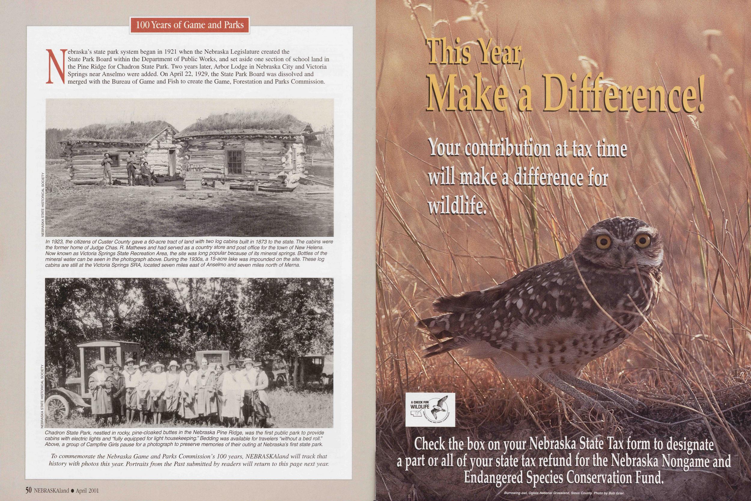
100 Years of Game and Parks
Nebraska’s state park system began in 1921 when the Nebraska Legislature created the State Park Board within the Department of Public Works, and set aside one section of school land in the Pine Ridge for Chadron State Park. Two years later, Arbor Lodge in Nebraska City and Victoria Springs near Anselmo were added. On April 22, 1929, the State Park Board was dissolved and merged with the Bureau of Game and Fish to create the Game, Forestation and Parks Commission.
In 1923, the citizens of Custer County gave a 60-acre tract of land with two log cabins built in 1873 to the state. The cabins were the former home of Judge Chas. R. Mathews and had served as a country store and post office for the town of New Helena. Now known as Victoria Springs State Recreation Area, the site was long popular because of its mineral springs. Bottles of the mineral water can be seen in the photograph above. During the 1930s, a 15-acre lake was impounded on the site. These log cabins are still at the Victoria Springs SR A, located seven miles east of Anselmo and seven miles north of Merna.
Chadron State Park, nestled in rocky, pine-cloaked buttes in the Nebraska Pine Ridge, was the first public park to provide cabins with electric lights and “fully equipped for light housekeeping.” Bedding was available for travelers “without a bed roll.” Above, a group of Campfire Girls pause for a photograph to preserve memories of their outing at Nebraska’s first state park.
 NEBRASKAland Magazine Vol 79, Number 3, April 2001 Published by the Nebraska Game and Parks Commission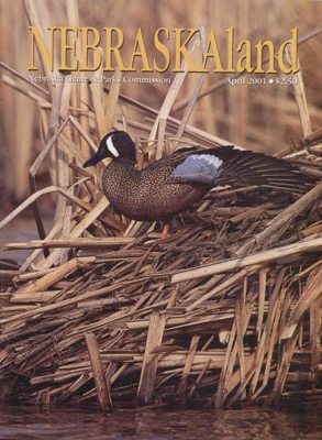
Position: 305 (29 views)