Volume 69, Issue 6, 1991
NEBRASKAland
JULY 1991 $1.50
. 8
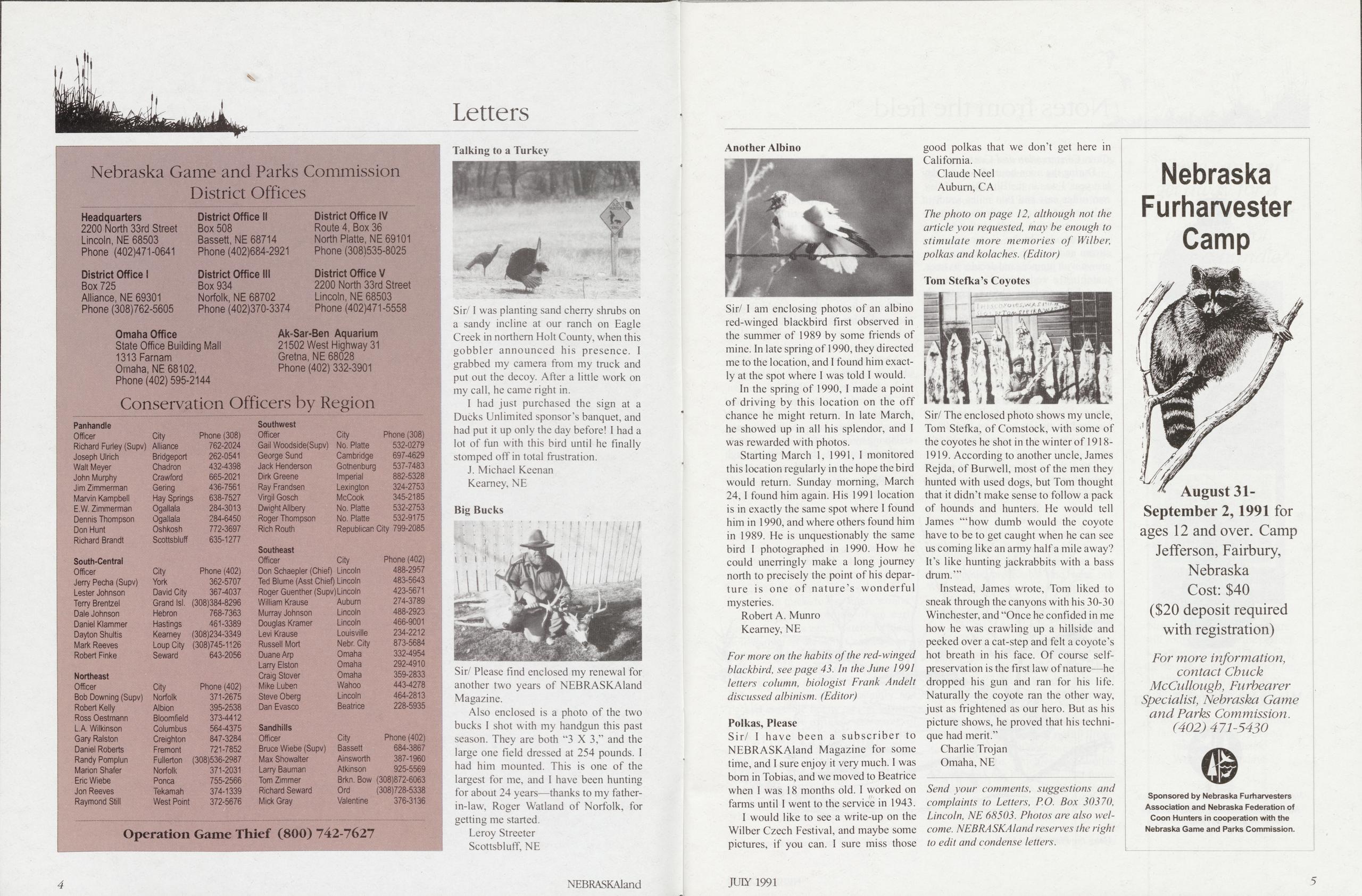
Sir/I was planting sand cherry shrubs on a sandy incline at our ranch on Eagle Creek in northern Holt County, when this gobbler announced his presence. I grabbed my camera from my truck and put out the decoy. After a little work on my call, he came right in. I had just purchased the sign at a Ducks Unlimited sponsor’s banquet, and had put it up only the day before! I had a lot of fun with this bird until he finally stomped off in total frustration.
J. Michael KeenanKearney, NE Big Bucks
Sir/ Please find enclosed my renewal for another two years of NEBRASKAland Magazine.
Also enclosed is a photo of the two bucks I shot with my handgun this past season. They are both “3 X 3,” and the large one field dressed at 254 pounds. 1 had him mounted. This is one of the largest for me, and I have been hunting for about 24 years—thanks to my father- in-law, Roger Watland of Norfolk, for getting me started.
Leroy StreeterScottsbluff, NE Another Albino
Sir/ I am enclosing photos of an albino red-winged blackbird first observed in the summer of 1989 by some friends of mine. In late spring of 1990, they directed me to the location, and I found him exactly at the spot where I was told I would. In the spring of 1990, I made a point of driving by this location on the off chance he might return. In late March, he showed up in all his splendor, and I was rewarded with photos.
Starting March 1, 1991, I monitored this location regularly in the hope the bird would return. Sunday morning, March 24, I found him again. His 1991 location is in exactly the same spot where I found him in 1990, and where others found him in 1989. He is unquestionably the same bird I photographed in 1990. How he could unerringly make a long journey north to precisely the point of his departure is one of nature’s wonderful mysteries.
Robert A. MunroKearney, NE For more on the habits of the red-winged blackbird, see page 43. In the June 1991 letters column, biologist Frank Andelt discussed albinism. (Editor) Polkas, Please
Sir/ I have been a subscriber to NEBRASKAland Magazine for some time, and I sure enjoy it very much. I was bom in Tobias, and we moved to Beatrice when I was 18 months old. I worked on farms until I went to the service in 1943. I would like to see a write-up on the Wilber Czech Festival, and maybe some pictures, if you can. I sure miss those good polkas that we don't get here in California.
Claude NeelAuburn, CA The photo on page 12, although not the article you requested, may be enough to stimulate more memories of Wilber, polkas and koiaches. (Editor) Tom Stefka’s Coyotes
Sir/ The enclosed photo shows my uncle, Tom Stefka, of Comstock, with some of the coyotes he shot in the winter of 1918- 1919. According to another uncle, James Rejda, of Burwell, most of the men they hunted with used dogs, but Tom thought that it didn’t make sense to follow a pack of hounds and hunters. He would tell James “‘how dumb would the coyote have to be to get caught when he can see us coming like an army half a mile away? It’s like hunting jackrabbits with a bass drum.’”
Instead, James wrote, Tom liked to sneak through the canyons with his 30-30 Winchester, and “Once he confided in me how he was crawling up a hillside and peeked over a cat-step and felt a coyote’s hot breath in his face. Of course self- preservation is the first law of nature—he dropped his gun and ran for his life. Naturally the coyote ran the other way, just as frightened as our hero. But as his picture shows, he proved that his technique had merit.”
Charlie TrojanOmaha, NE Send your comments, suggestions and complaints to Letters, P.O. Box 30370, Lincoln, NE 68503. Photos are also wel- come. NEBRASKAland reserves the right to edit and condense letters.
During the noon hour of a spring day last year, I was in the Blue River Valley, two miles east and two miles south of Polk, standing on a minimum maintenance mile that winds south from the small, wooden bridge that crosses the stream and through a pasture area over-grown with junipers and deciduous trees, watching a red-bellied woodpecker through binoculars, when a coyote appeared from the west and crossed the road at a steady trot, less than a hundred feet from me.
I remained rigid as a fence post, watching the coyote’s lithe movements that would make awkward those of a trotting, domestic dog. The coyote didn’t see me nor catch a whiff of my scent. It stopped to nose through a patch of tall weeds, then resumed its tireless trot east and disappeared in a grove of trees and brush to the east.
The sight of that wild animal and its tireless trot reminded me of a quote from "The Outermost House” by Henry Beston, a story he wrote after spending a winter in a house farthest out on Cape Cod. The quote was printed for a judge, who had requested Harold Berliner, printer- lawyer, to design the printing in large enough size to hang on the wall and be easily read.
Berliner gave me a copy of the print, because he had used a quote from a Polk Progress editorial in one of his many class action suits against developers in California, forcing them to help finance the establishment of public services— schools, for example—after selling houses in a real estate development. I had the quote framed, 20 by 26 inches, and it hangs on the wall above my desk where I’m typing this.
“We need another and a wiser and perhaps a more mystical concept of animals. Remote from universal nature, and living by complicated artifice, man in civilization surveys the creature through the glass of his knowledge and sees thereby a feather magnified and the whole image in distortion. We patronize them
for their incompleteness, for their tragic fate of having taken form so far below ourselves. And therein we err, and greatly err. For the animal shall not be measured by man. In a world older and more complete than ours they move finished and complete, gifted with extensions of the senses we have lost or never attained, living by voices we shall never hear. They are not brethren, they are not underlings; they are other nations, caught with ourselves in the net of life and time, fellow prisoners of the splendour and travail of the earth.”
Copies of the printed quote are now available in nature centers in California. I have one of the original prints and treasure it. The last sentence of the quote may have been the inspiration for “Trapped In Our Time” a boxed thought printed on the front page of the May 1991 Polking Around. The beginning and ending fit the concept of “prisoners.” “We are trapped in our time and caught in a cage of our convictions. ... Our time is not the only time, but the planet is the only place. A lone star of living light beyond which all is dark and conjecture. We know we are. What we don’t know is an immensity. What we never will know is another great mystery, lost forever to even those who read rocks.
“Tread the terrain lightly, leaving no treacherous tracks to trap future’s trails.” One Sunday morning of an early spring day, years ago, I watched a black- poll warbler in the Polk Cemetery, as it searched purposefully, intently, a leaf- budding tree branch three feet above my head. That little bird was oblivious of my presence as it moved constantly and pecked at edible tidbits on leaf-bursting twigs. To that diligent devourer of nature’s crumbs I was another tombstone, albeit an enthralled one. I remained motionless as a grave marker while Observing that bit of the Grand Design go about its business of living.
The blackpoll warbler was a small whit of the infinite variety of life on earth and I, momentarily, wondered about size and significance. That little bird wasn’t concerned about nor even noticing me. To the blackpoll warbler, I was no-account, insignificant. My death wouldn’t upset its life. Would the bird’s death upset mine? One bird’s death would not be distressing. If the blackpoll warbler joined the passenger pigeon, Eskimo curlew, great auk and seaside sparrow as an extinct species, that would be cause for worry. Every spring the sight of migrating birds is reassuring. Just as surging green growth renews the spirit, so do spring warblers migrating north. A gnawing uneasiness that human exploitation may be upsetting the planet’s rhythms subsides with the spring migration. The little beasties survived another winter. The Grand Design is still intact.
There is a Grand Design. A functioning, throbbing whole of which the blackpoll warbler is a part. That bird flew north and found food in a Polk Cemetery tree. Accidental? Not likely. The warbler demonstrated repetitious purpose in its hunger and unawareness of my presence. That repetition has been described as machine-like, but life is more than mechanical motion honed to ten- thousandths of an inch. Earth supports life that has hopes, love and the capacity to cope with the unexpected. Machines are monotonous, predictable and wear out. With care and conservation the earth won’t.
One more necessary condition— Time fills the measures of all existence and never overflows. Whether we have enough time to correct our environmental errors—that destruction of those vital connections that sustain us and fasten us to all earth life and a liveable future—I don’t know. No one knows the measure until time fills it.
We are now aware of awesome, man- made dangers to the planet and all life on it, having discovered our connections by destroying them, which is uncontrolled research into our limitations. The future is not open ended. So, I add one more condition necessary for preventing the planet from wearing out. It will take care, conservation and contentment.
Norris Alfred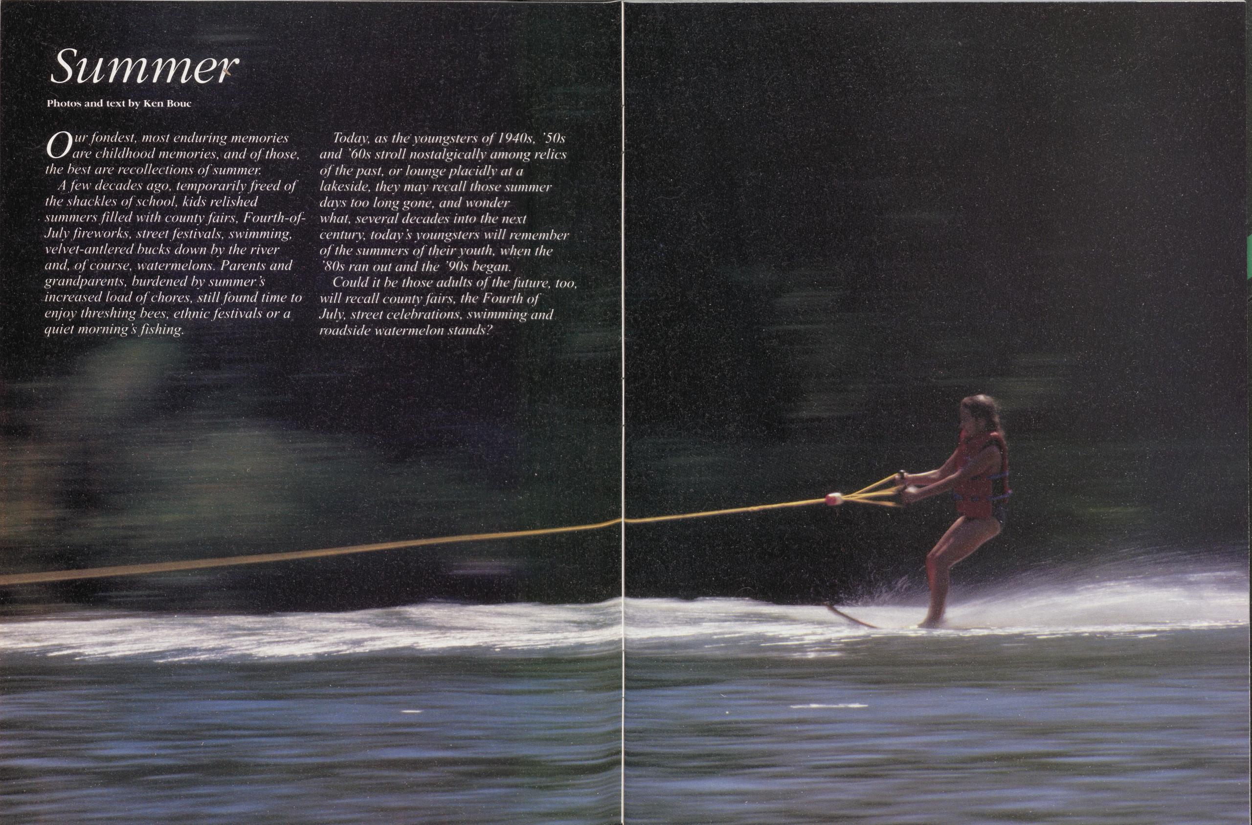
Our fondest, most enduring memories are childhood memories, and of those, the best are recollections of summer.
A few decades ago, temporarily freed of the shackles of school, kids relished summers filled with county fairs, Fourth-of- July fireworks, street festivals, swimming, velvet-antlered bucks down by the river and, of course, watermelons. Parents and grandparents, burdened by summer s increased load of chores, still found time to enjoy threshing bees, ethnic festivals or a quiet mornings fishing.
Today, as the youngsters of 1940s, '50s and '60s stroll nostalgically among relics of the past, or lounge placidly at a lakeside, they may recall those summer days too long gone, and wonder what, several decades into the next century, today s youngsters will remember of the summers of their youth, when the '80s ran out and the '90s began.
Could it be those adults of the future, too, will recall county fairs, the Fourth of July, street celebrations, swimming and roadside watermelon stands?

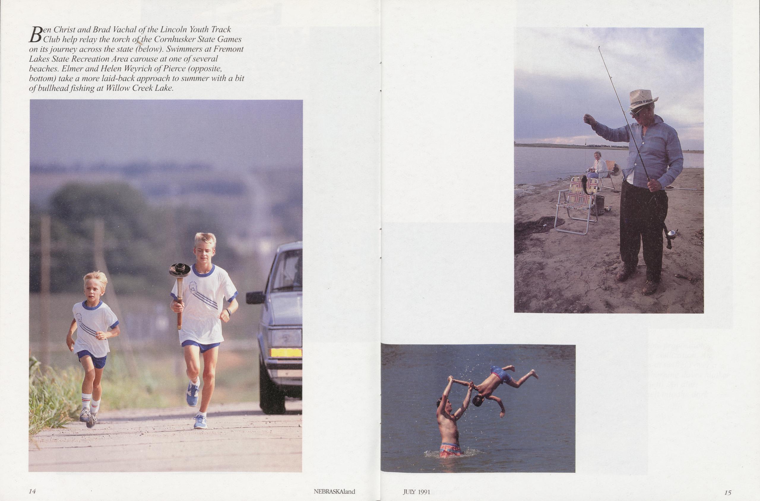
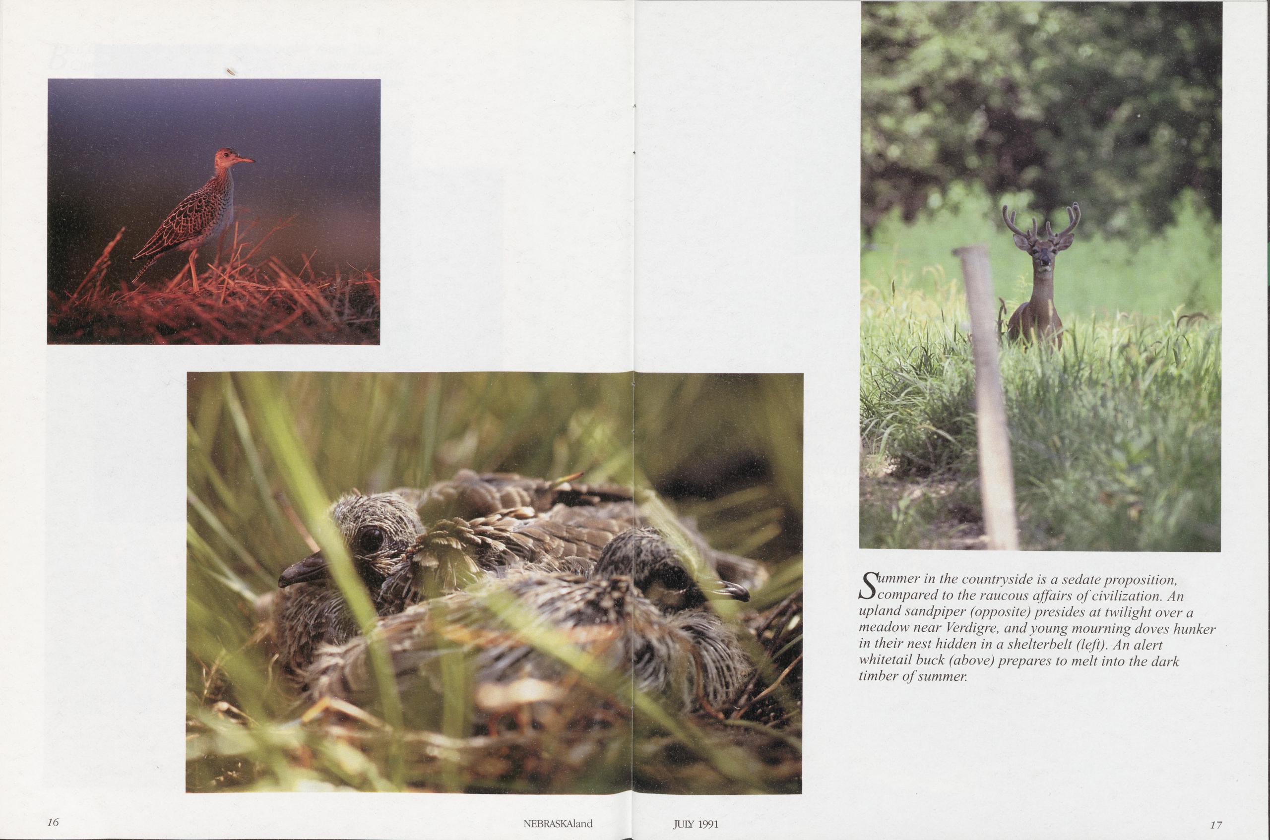
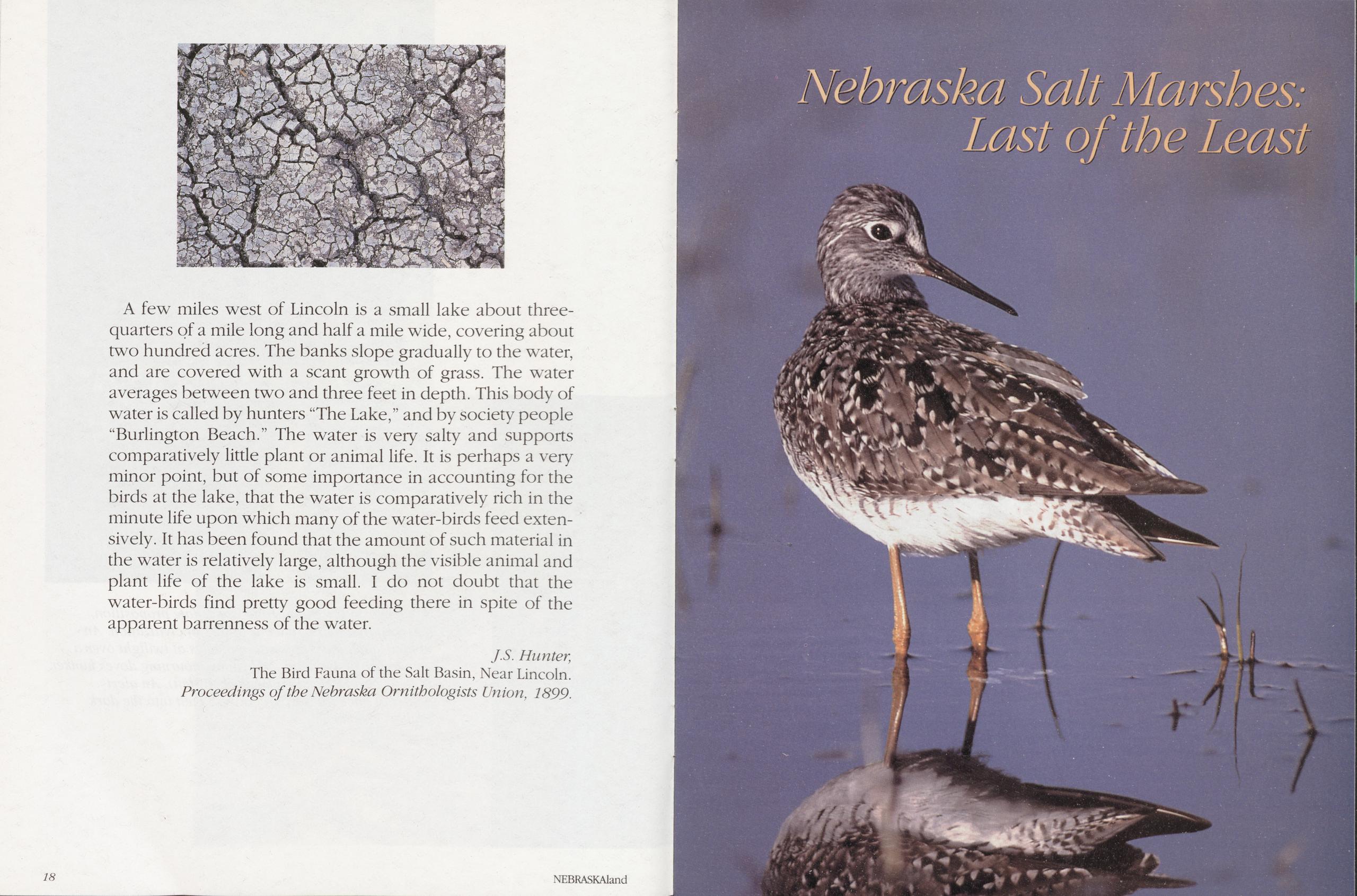
A few miles west of Lincoln is a small lake about three- quarters of a mile long and half a mile wide, covering about two hundred acres. The banks slope gradually to the water, and are covered with a scant growth of grass. The water averages between two and three feet in depth. This body of water is called by hunters “The Lake,” and by society people “Burlington Beach.” The water is very salty and supports comparatively little plant or animal life. It is perhaps a very minor point, but of some importance in accounting for the birds at the lake, that the water is comparatively rich in the minute life upon which many of the water-birds feed extensively. It has been found that the amount of such material in the water is relatively large, although the visible animal and plant life of the lake is small. I do not doubt that the water-birds find pretty good feeding there in spite of the apparent barrenness of the water.
J.S. Hunter, The Bird Fauna of the Salt Basin, Near Lincoln. Proceedings of the Nebraska Ornithologists Union, 1899. Nebraska Salt Marshes: Last of the Least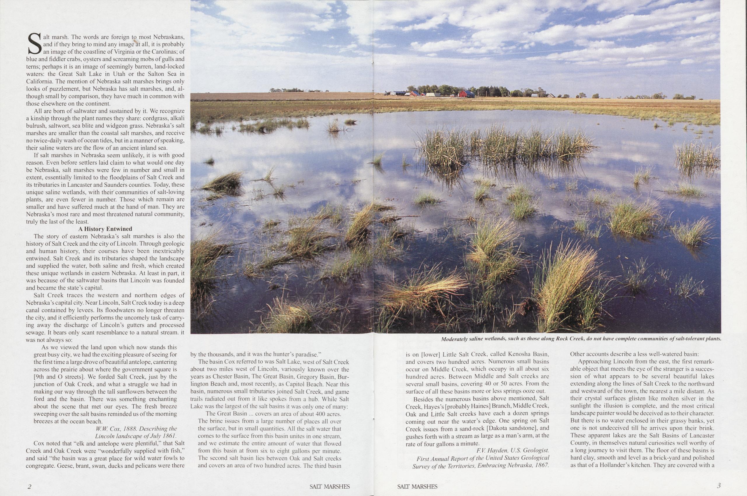
Salt marsh. The words are foreign to most Nebraskans, and if they bring to mind any image'at all, it is probably an image of the eoastline of Virginia or the Carolinas; of blue and fiddler crabs, oysters and screaming mobs of gulls and terns; perhaps it is an image of seemingly barren, land-locked waters: the Great Salt Lake in Utah or the Salton Sea in California. The mention of Nebraska salt marshes brings only looks of puzzlement, but Nebraska has salt marshes, and, although small by comparison, they have much in common with those elsewhere on the continent.
All are bom of saltwater and sustained by it. We recognize a kinship through the plant names they share: cordgrass, alkali bulrush, saltwort, sea blite and widgeon grass. Nebraska’s salt marshes are smaller than the coastal salt marshes, and receive no twice-daily wash of ocean tides, but in a manner of speaking, their saline waters are the flow of an ancient inland sea. If salt marshes in Nebraska seem unlikely, it is with good reason. Even before settlers laid claim to what would one day be Nebraska, salt marshes were few in number and small in extent, essentially limited to the floodplains of Salt Creek and its tributaries in Lancaster and Saunders counties. Today, these unique saline wetlands, with their'communities of salt-loving plants, are even fewer in number. Those which remain are smaller and have suffered much at the hand of man. They are Nebraska’s most rare and most threatened natural community, truly the last of the least.
A History EntwinedThe story of eastern Nebraska’s salt marshes is also the history of Salt Creek and the city of Lincoln. Through geologic and human history, their courses have been inextricably entwined. Salt Creek and its tributaries shaped the landscape and supplied the water, both saline and fresh, which created these unique wetlands in eastern Nebraska. At least in part, it was because of the saltwater basins that Lincoln was founded and became the state’s capital.
Salt Creek traces the western and northern edges of Nebraska’s capital city. Near Lincoln, Salt Creek today is a deep canal contained by levees. Its floodwaters no longer threaten the city, and it efficiently performs the uncomely task of carrying away the discharge of Lincoln’s gutters and processed sewage. It bears only scant resemblance to a natural stream, it was not always so:
As we viewed the land upon which now stands this great busy city, we had the exciting pleasure of seeing for the first time a large drove of beautiful antelope, cantering across the prairie about where the government square is [9th and O streets]. We forded Salt Creek, just by the junction of Oak Creek, and what a struggle we had in making our way through the tall sunflowers between the ford and the basin. There was something enchanting about the scene that met our eyes. The fresh breeze sweeping over the salt basins reminded us of the morning breezes at the ocean beach.
W.W. Cox, 1888. Describing the Lincoln landscape of July 1861.Cox noted that “elk and antelope were plentiful,” that Salt Creek and Oak Creek were “wonderfully supplied with fish,” and said “the basin was a great place for wild water fowls to congregate. Geese, brant, swan, ducks and pelicans were there Moderately saline wetlands, such as those along Rock Creek, do not have complete communities of salt-tolerant plants. by the thousands, and it was the hunter’s paradise.”
The basin Cox referred to was Salt Lake, west of Salt Creek about two miles west of Lincoln, variously known over the years as Chester Basin, The Great Basin, Gregory Basin, Burlington Beach and, most recently, as Capitol Beach. Near this basin, numerous small tributaries joined Salt Creek, and game trails radiated out from it like spokes from a hub. While Salt Lake was the largest of the salt basins it was only one of many:
The Great Basin ... covers an area of about 400 acres. The brine issues from a large number of places all over the surface, but in small quantities. All the salt water that comes to the surface from this basin unites in one stream, and we estimate the entire amount of water that flowed from this basin at from six to eight gallons per minute. The second salt basin lies between Oak and Salt creeks and covers an area of two hundred acres. The third basin is on [lower] Little Salt Creek, called Kenosha Basin, and covers two hundred acres. Numerous small basins occur on Middle Creek, which occupy in all about six hundred acres. Between Middle and Salt creeks are several small basins, covering 40 or 50 acres. From the surface of all these basins more or less springs ooze out. Besides the numerous basins above mentioned, Salt Creek, Hayes’s [probably Haines] Branch, Middle Creek, Oak and Little Salt creeks have each a dozen springs coming out near the water’s edge. One spring on Salt Creek issues from a sand-rock [Dakota sandstone], and gushes forth with a stream as large as a man’s arm, at the rate of four gallons a minute.
F.V Hayden, U.S. Geologist. First Annual Report of the United States Geological Survey of the Territories, Embracing Nebraska, 1867.Other accounts describe a less well-watered basin: Approaching Lincoln from the east, the first remarkable object that meets the eye of the stranger is a succession of what appears to be several beautiful lakes extending along the lines of Salt Creek to the northward and westward of the town, the nearest a mile distant. As their crystal surfaces glisten like molten silver in the sunlight the illusion is complete, and the most critical landscape painter would be deceived as to their character. But there is no water enclosed in their grassy banks, yet one is not undeceived till he arrives upon their brink. These apparent lakes are the Salt Basins of Lancaster County, in themselves natural curiosities well worthy of a long journey to visit them. The floor of these basins is hard clay, smooth and level as a brick-yard and polished as that of a Hollander’s kitchen. They are covered with a
2 SALT MARSHES SALT MARSHES 3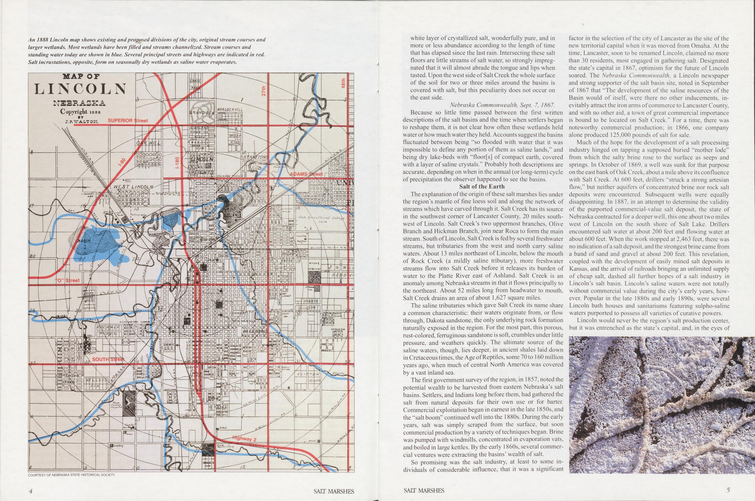
white layer of crystallized salt, wonderfully pure, and in more or less abundance according to the length of time that has elapsed since the last rain. Intersecting these salt floors are little streams of salt water, so strongly impregnated that it will almost abrade the tongue and lips when tasted. Upon the west side of Salt Creek the whole surface of the soil for two or three miles around the basins is covered with salt, but this peculiarity does not occur on the east side.
Nebraska Commonwealth, Sept. 7, 1867.Because so little time passed between the first written descriptions of the salt basins and the time when settlers began to reshape them, it is not clear how often these wetlands held water or how much water they held. Accounts suggest the basins fluctuated between being "so flooded with water that it was impossible to define any portion of them as saline lands,” and being dry lake-beds with "floor[s] of compact earth, covered with a layer of saline crystals.” Probably both descriptions are accurate, depending on when in the annual (or long-term) cycle of precipitation the observer happened to see the basins.
Salt of the EarthThe explanation of the origin of these salt marshes lies under the region’s mantle of fine loess soil and along the network of streams which have carved through it. Salt Creek has its source in the southwest comer of Lancaster County, 20 miles southwest of Lincoln. Salt Creek’s two uppermost branches, Olive Branch and Hickman Branch join near Roca to form the main stream. South of Lincoln, Salt Creek is fed by several freshwater streams, but tributaries from the west and north carry saline waters. About 13 miles northeast of Lincoln, below the mouth of Rock Creek (a mildly saline tributary), more freshwater streams flow into Salt Creek before it releases its burden of water to the Platte River east of Ashland. Salt Creek is an anomaly among Nebraska streams in that it flows principally to the northeast. About 52 miles long from headwater to mouth, Salt Creek drains an area of about 1,627 square miles. The saline tributaries which gave Salt Creek its name share a common characteristic: their waters originate from, or flow through, Dakota sandstone, the only underlying rock formation naturally exposed in the region. For the most part, this porous, rust-colored, ferruginous sandstone is soft, crumbles under little pressure, and weathers quickly. The ultimate source of the saline waters, though, lies deeper, in ancient shales laid down in Cretaceous times, the Age of Reptiles, some 70 to 160 million years ago, when much of central North America was covered by a vast inland sea.
The first government survey of the region, in 1857, noted the potential wealth to be harvested from eastern Nebraska's salt basins. Settlers, and Indians long before them, had gathered the salt from natural deposits for their own use or for barter. Commercial exploitation began in earnest in the late 1850s, and the "salt boom” continued well into the 1880s. During the early years, salt was simply scraped from the surface, but soon commercial production by a variety of techniques began. Brine was pumped with windmills, concentrated in evaporation vats, and boiled in large kettles. By the early 1860s, several commercial ventures were extracting the basins’ wealth of salt.
So promising was the salt industry, at least to some in- dividuals of considerable influence, that it was a significant factor in the selection of the city of Lancaster as the site of the new territorial capital when it was moved from Omaha. At the time, Lancaster, soon to be renamed Lincoln, claimed no more than 30 residents, most engaged in gathering salt. Designated the state’s capital in 1867, optimism for the future of Lincoln soared. The Nebraska Commonwealth, a Lincoln newspaper and strong supporter of the salt basin site, noted in September of 1867 that "The development of the saline resources of the Basin would of itself, were there no other inducements, inevitably attract the iron arms of commerce to Lancaster County, and with no other aid, a town of great commercial importance is bound to be located on Salt Creek.” For a time, there was noteworthy commercial production; in 1866, one company alone produced 125,000 pounds of salt for sale.
Much of the hope for the development of a salt processing industry hinged on tapping a supposed buried "mother lode” from which the salty brine rose to the surface as seeps and springs. In October of 1869, a well was sunk for that purpose on the east bank of Oak Creek, about a mile above its confluence with Salt Creek. At 600 feet, drillers "struck a strong artesian flow,” but neither aquifers of concentrated brine nor rock salt deposits were encountered. Subsequent wells were equally disappointing. In 1887, in an attempt to determine the validity of the purported commercial-value salt deposit, the state of Nebraska contracted for a deeper well, this one about two miles west of Lincoln on the south shore of Salt Lake. Drillers encountered salt water at about 200 feet and flowing water at about 600 feet. When the work stopped at 2,463 feet, there was no indication of a salt deposit, and the strongest brine came from a band of sand and gravel at about 200 feet. This revelation, coupled with the development of easily mined salt deposits in Kansas, and the arrival of railroads bringing an unlimited supply of cheap salt, dashed all further hopes of a salt industry in Lincoln’s salt basin. Lincoln’s saline waters were not totally without commercial value during the city’s early years, however. Popular in the late 1880s and early 1890s, were several Lincoln bath houses and sanitariums featuring sulpho-saline waters purported to possess all varieties of curative powers.
Lincoln would never be the region’s salt production center,
but it was entrenched as the state’s capital, and, in the eyes of
4
SALT MARSHES
SALT MARSHES
5
 many, it was situated in a most undesirable location:
While this one-time famous salt basin yielded no
important benefits to mankind, it unfortunately influenced the commissioners to unwisely
plant the capital
city in a semi-basin in its uncomely and otherwise injurious contiguity, from which,
year by year, it instinctively shrinks toward the sightliness, salubrity, and
unsalted water supply of the adjacent but originally
slighted slopes.
many, it was situated in a most undesirable location:
While this one-time famous salt basin yielded no
important benefits to mankind, it unfortunately influenced the commissioners to unwisely
plant the capital
city in a semi-basin in its uncomely and otherwise injurious contiguity, from which,
year by year, it instinctively shrinks toward the sightliness, salubrity, and
unsalted water supply of the adjacent but originally
slighted slopes.
The city of Lincoln lies in a roughly elliptical dish about 12 miles from north to south and 25 miles from east to west, a dish carved from the once rolling landscape by Salt Creek and its smaller tributaries which merge there. A nearly level terrace, one- to three-quarters of a mile wide, and 15 to 20 feet higher in elevation, bounds Salt Creek’s floodplain. On this terrace, Lincoln’s first buildings would rise, and the central business district would reside. From that terrace, the land gradually rose to become rolling grassland. The selection of this site as the state capital would ultimately sound the death knell for most of the salt marshes over which Lincoln would one day sprawl.
Reshaping the LandscapeNebraska’s Salt Lake did not sit idle after it was abandoned by the short-lived salt industry. The test well dug by the state on the south shore of Salt Lake in 1887 continued to discharge its briny waters into the basin, and in 1895, a pair of entrepreneurs envisioned yet another path to riches by way of the salt basin. By diking the east end of the basin and diverting Oak Creek into it, a permanent lake about a mile long and half as wide was created. Soon the waters were plied by an excursion steamboat, and were lined with groves of trees, pavilions, bath houses and restaurants. A Burlington Railroad spur carried visitors from Lincoln and the surrounding area to Nebraska’s inland beach, and so it was named Burlington Beach.
Burlington Beach’s crowds and the lake itself shriveled when the dike began to leak. In 1906, the development was revived under new ownership and a new name, Capital Beach (more commonly spelled Capitol Beach today). Less than a decade later, the "Coney Island of the West” was again on the decline and, against the advice of the Lincoln State Journal, the city of Lincoln decided against a proposal to purchase—for $100,000—875 acres encompassing Salt Lake as a city park: Anyone with a spark of imagination cannot help view- ing with enthusiasm the prospect of Capital Beach as a part of the city’s park system. Here is Lincoln in the midst of a level plain, without rugged scenery and without a river. It seems like a special providence that at its very gates there should be a lake a mile long and a mile wide which could be made into a free vacation resort for the entire city. This lake, surrounded by trees and walks and drives, as it would be, and with ample park space on all sides is undoubtedly the city’s greatest potential natural asset.
Lincoln State Journal, August 2, 1915.In the 1920s, Capitol Beach was once again revived as a privately owned amusement park and saltwater resort. Until the early 1960s, the area flourished, featuring a saltwater swimming pool, dance hall and amusement park.
From the beginning, Salt Lake, for one reason or another, was seen to have some value. Smaller wetlands near Lincoln were not viewed so kindly. Salt marshes and streams merging in the basin over which Lincoln was expanding were considered impediments to progress. In the first half of the 20th century, most of Lincoln’s growth had been to the east and south, the city instinctively cringing from the low-lying and frequently flooded marsh ground to the west and north. Although not by grand design, a pattern emerged which would subdue Salt Creek and fill the wetlands associated with it. The destruction of Salt Creek’s saline wetlands was accomplished directly by draining and filling low-lying areas, and indirectly by straightening and deepening Salt Creek’s channel and the lower reaches of several of its tributaries.
The early history of wetland destruction in the Lincoln area is not well documented, but apparently lowlands between downtown Lincoln and Salt Lake were targeted for filling early in the century. From the 1930s until the mid-1950s, low ground and wetlands near Oak Lake, just to the east of Salt Lake, were used as the city dump. Today, grass grows over former wetlands filled with two decades or more of Lincoln’s garbage, and 1-180 severs Oak Lake.
As recently as the 1980s, wetlands west of downtown Lincoln were still being filled with rubble—spoil from construction sites, demolished buildings, trees, bricks, anything that could be hauled, that had to be disposed of and would raise the level of the land. Most of the wetlands east and south of Salt Lake, on both sides of West O Street and south to the Burlington Railroad Yards, were filled and prepared for industrial, commercial and housing developments. Additional impetus for draining and filling these wetlands was provided by America’s mosquito phobia of the 1950s.
Saline wetlands on Lincoln’s northern edge survived a bit longer. Many were still attractive to waterbirds and waterfowl
hunters in the 1950s, some into the 1960s. A handful of these wetlands, particularly those on lower Little Salt Creek, are still hunted today. But, just as a city dump had filled the wetlands surrounding Oak Lake, the new landfill on North 48th Street north of Superior Street claimed several of the best saline wetlands on Lincoln’s northern edge from the mid-1950’s until it was closed in 1988.
Perhaps the best known of these wetlands was Roper's Pond, located west of the landfill and bounded on the north and west by a bend of Salt Creek. During the 1940s and 1950s, hunting blinds on Roper’s Pond were frequented by many of Lincoln’s prominent citizens, as were other wetlands along Little Salt Creek just to the north. Retrieving dog field trials were regularly held on Roper’s Pond. East of Roper’s Pond, south of Salt Creek and just west of Highway 77, was a series of narrow wetlands, probably oxbows left behind when Salt Creek changed its course. At least one of these lakes, Roller’s Pond, was deep enough to be used as a pay-to-fish area. Although altered by land changes near it, Roper’s Pond has survived, but today, Reller’s Pond and other wetlands to the east of Roper’s Pond are covered by the former Lincoln landfill.
Prior to the 1960s, many other wetlands and oxbow ponds along Salt Creek northeast of Lincoln were frequented by both waterfowl and waterfowl hunters. All these wetlands on Lincoln’s northern edge were known by name to local hunters and to young boys who regularly sneaked onto them for a chance shot at a duck.
Salt Lake, west of town, was also a popular waterfowl hunting spot. Even in the early 1950s, right up to the time Salt Lake was drained in 1958 so construction of 1-80 could begin, there were eight to 10 blinds on the lake. The lake was still surrounded by pasture and haystacks, and shooting was said to be reliably good for early-migrating ducks and occasional geese, particularly snow geese.
In the summer of 1958, two ditches drained Salt Lake into Oak Creek in preparation for the construction of Interstate 80.
6 SALT MARSHES SALT MARSHES 7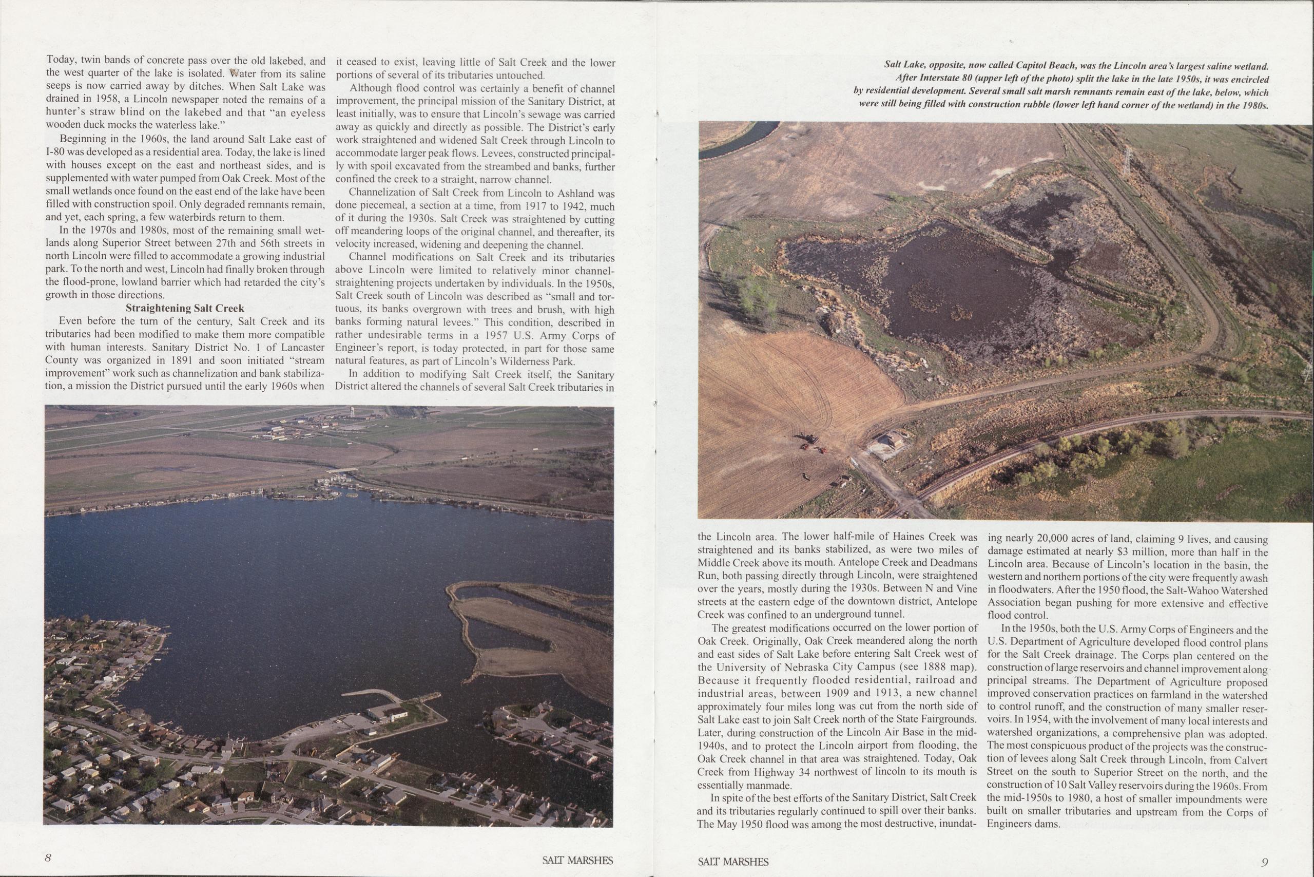
Today, twin bands of concrete pass over the old lakebed, and the west quarter of the lake is isolated. Water from its saline seeps is now carried away by ditches. When Salt Lake was drained in 1958, a Lincoln newspaper noted the remains of a hunter’s straw blind on the lakebed and that "an eyeless wooden duck mocks the waterless lake.”
Beginning in the 1960s, the land around Salt Lake east of 1-80 was developed as a residential area. Today, the lake is lined with houses except on the east and northeast sides, and is supplemented with water pumped from Oak Creek. Most of the small wetlands once found on the east end of the lake have been filled with construction spoil. Only degraded remnants remain, and yet, each spring, a few waterbirds return to them. In the 1970s and 1980s, most of the remaining small wetlands along Superior Street between 27th and 56th streets in north Lincoln were filled to accommodate a growing industrial park. To the north and west, Lincoln had finally broken through the flood-prone, lowland barrier which had retarded the city’s growth in those directions.
Straightening Salt CreekEven before the turn of the century, Salt Creek and its tributaries had been modified to make them more compatible with human interests. Sanitary District No. 1 of Lancaster County was organized in 1891 and soon initiated "stream improvement” work such as channelization and bank stabilization, a mission the District pursued until the early 1960s when it ceased to exist, leaving little of Salt Creek and the lower portions of several of its tributaries untouched Although flood control was certainly a benefit of channel improvement, the principal mission of the Sanitary District, at least initially, was to ensure that Lincoln’s sewage was carried away as quickly and directly as possible. The District’s early work straightened and widened Salt Creek through Lincoln to accommodate larger peak flows. Levees, constructed principally with spoil excavated from the streambed and banks, further confined the creek to a straight, narrow channel.
Channelization of Salt Creek from Lincoln to Ashland was done piecemeal, a section at a time, from 1917 to 1942, much of it during the 1930s. Salt Creek was straightened by cutting off meandering loops of the original channel, and thereafter, its velocity increased, widening and deepening the channel.
Channel modifications on Salt Creek and its tributaries above Lincoln were limited to relatively minor channel- straightening projects undertaken by individuals. In the 1950s, Salt Creek south of Lincoln was described as "small and tortuous, its banks overgrown with trees and brush, with high banks forming natural levees.” This condition, described in rather undesirable terms in a 1957 U.S. Army Corps of Engineer’s report, is today protected, in part for those same natural features, as part of Lincoln’s Wilderness Park.
In addition to modifying Salt Creek itself, the Sanitary District altered the channels of several Salt Creek tributaries in
the Lincoln area. The lower half-mile of Haines Creek was straightened and its banks stabilized, as were two miles of Middle Creek above its mouth. Antelope Creek and Deadmans Run, both passing directly through Lincoln, were straightened over the years, mostly during the 1930s. Between N and Vine streets at the eastern edge of the downtown district, Antelope Creek was confined to an underground tunnel.
The greatest modifications occurred on the lower portion of Oak Creek. Originally, Oak Creek meandered along the north and east sides of Salt Lake before entering Salt Creek west of the University of Nebraska City Campus (see 1888 map). Because it frequently flooded residential, railroad and industrial areas, between 1909 and 1913, a new channel approximately four miles long was cut from the north side of Salt Lake east to join Salt Creek north of the State Fairgrounds. Later, during construction of the Lincoln Air Base in the mid- 1940s, and to protect the Lincoln airport from flooding, the Oak Creek channel in that area was straightened. Today, Oak Creek from Highway 34 northwest of lincoln to its mouth is essentially manmade.
In spite of the best efforts of the Sanitary District, Salt Creek and its tributaries regularly continued to spill over their banks. The May 1950 flood was among the most destructive, inundat- ing nearly 20,000 acres of land, claiming 9 lives, and causing damage estimated at nearly $3 million, more than half in the Lincoln area. Because of Lincoln’s location in the basin, the western and northern portions of the city were frequently awash in floodwaters. After the 1950 flood, the Salt-Wahoo Watershed Association began pushing for more extensive and effective flood control.
In the 1950s, both the U.S. Army Corps of Engineers and the U.S. Department of Agriculture developed flood control plans for the Salt Creek drainage. The Corps plan centered on the construction of large reservoirs and channel improvement along principal streams. The Department of Agriculture proposed improved conservation practices on farmland in the watershed to control runoff, and the construction of many smaller reservoirs. In 1954, with the involvement of many local interests and watershed organizations, a comprehensive plan was adopted. The most conspicuous product of the projects was the construction of levees along Salt Creek through Lincoln, from Calvert Street on the south to Superior Street on the north, and the construction of 10 Salt Valley reservoirs during the 1960s. From the mid-1950s to 1980, a host of smaller impoundments were built on smaller tributaries and upstream from the Corps of Engineers dams.
8 SALT MARSHES SALT MARSHES 9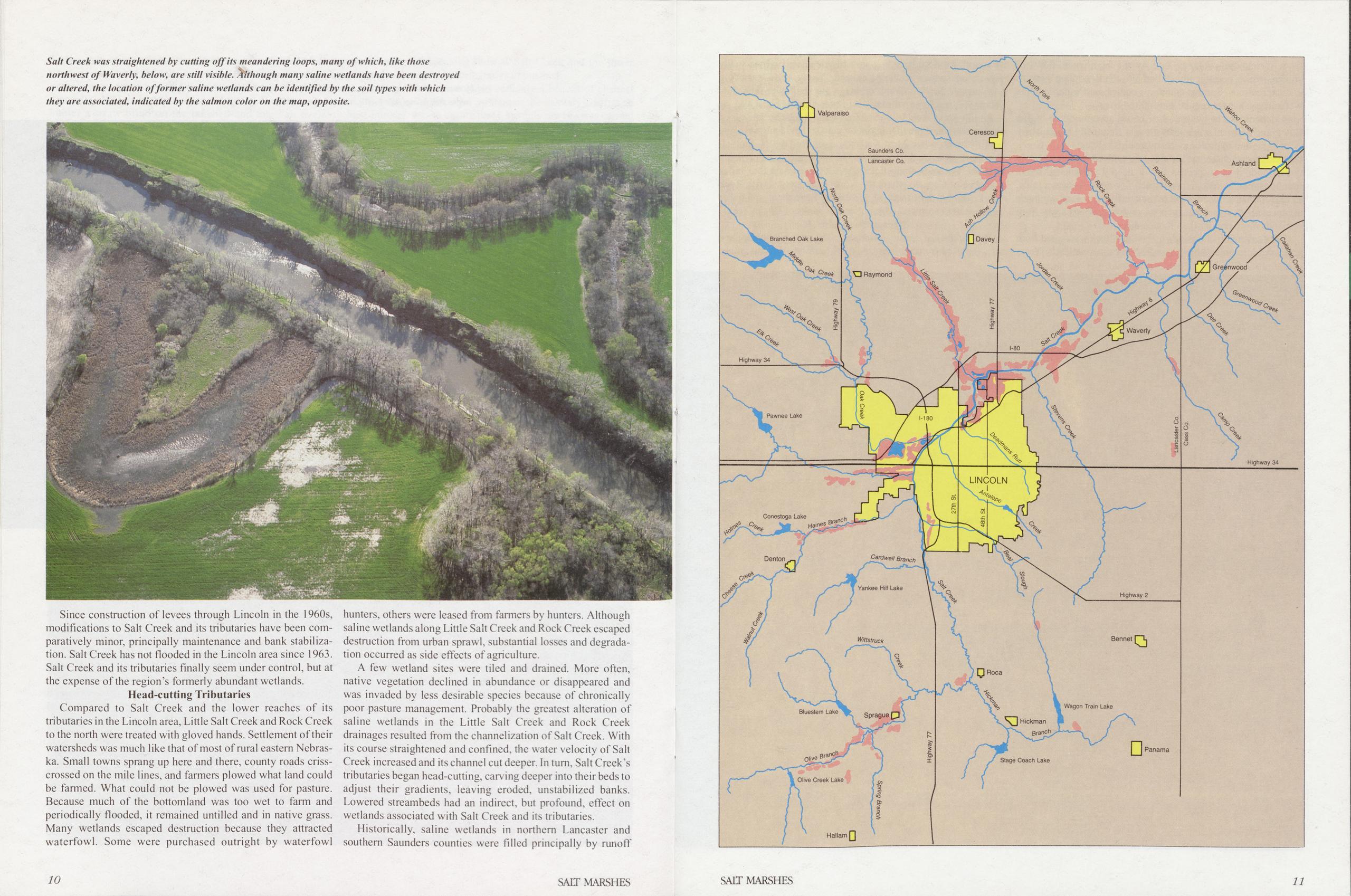
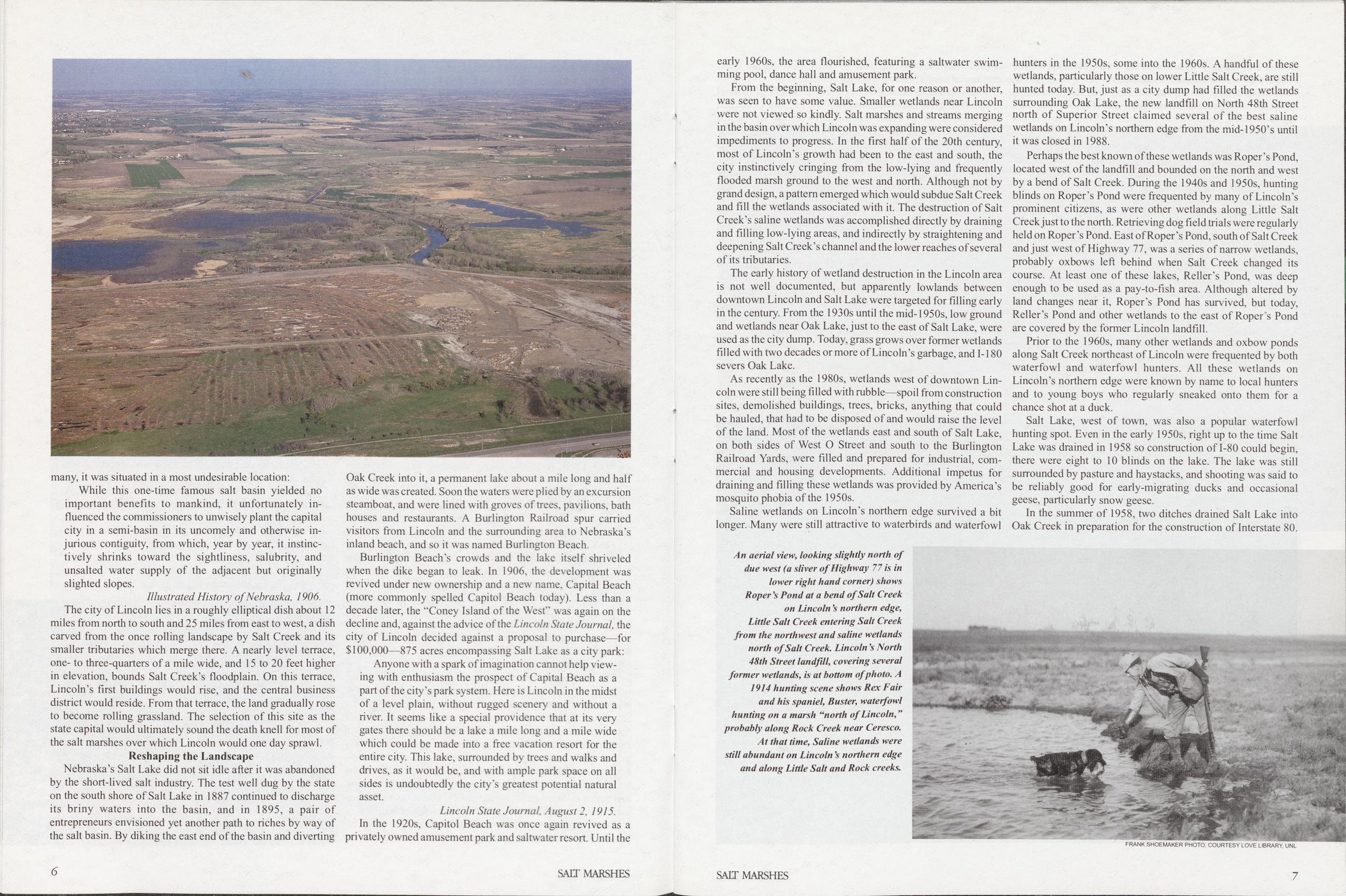
Salt Creek was straightened by cutting off its meandering loops, many of which, like those northwest of Waverly, below, are still visible. Although many saline wetlands have been destroyed or altered, the location of former saline wetlands can he identified by the soil types with which they are associated, indicated by the salmon color on the map, opposite. Since construction of levees through Lincoln in the 1960s, modifications to Salt Creek and its tributaries have been comparatively minor, principally maintenance and bank stabilization. Salt Creek has not flooded in the Lincoln area since 1963. Salt Creek and its tributaries finally seem under control, but at the expense of the region’s formerly abundant wetlands.
Head-cutting TributariesCompared to Salt Creek and the lower reaches of its tributaries in the Lincoln area, Little Salt Creek and Rock Creek to the north were treated with gloved hands. Settlement of their watersheds was much like that of most of rural eastern Nebraska. Small towns sprang up here and there, county roads criss- crossed on the mile lines, and farmers plowed what land could be farmed. What could not be plowed was used for pasture. Because much of the bottomland was too wet to farm and periodically flooded, it remained untilled and in native grass. Many wetlands escaped destruction because they attracted waterfowl. Some were purchased outright by waterfowl 10 hunters, others were leased from fanners by hunters. Although saline wetlands along Little Salt Creek and Rock Creek escaped destruction from urban sprawl, substantial losses and degradation occurred as side effects of agriculture.
A few wetland sites were tiled and drained. More often, native vegetation declined in abundance or disappeared and was invaded by less desirable species because of chronically poor pasture management. Probably the greatest alteration of saline wetlands in the Little Salt Creek and Rock Creek drainages resulted from the channelization of Salt Creek. With its course straightened and confined, the water velocity of Salt Creek increased and its channel cut deeper. In turn. Salt Creek’s tributaries began head-cutting, carving deeper into their beds to adjust their gradients, leaving eroded, unstabilized banks. Lowered streambeds had an indirect, but profound, effect on wetlands associated with Salt Creek and its tributaries. Historically, saline wetlands in northern Lancaster and southern Saunders counties were filled principally by runoff
SAIL MARSHES SALT MARSHES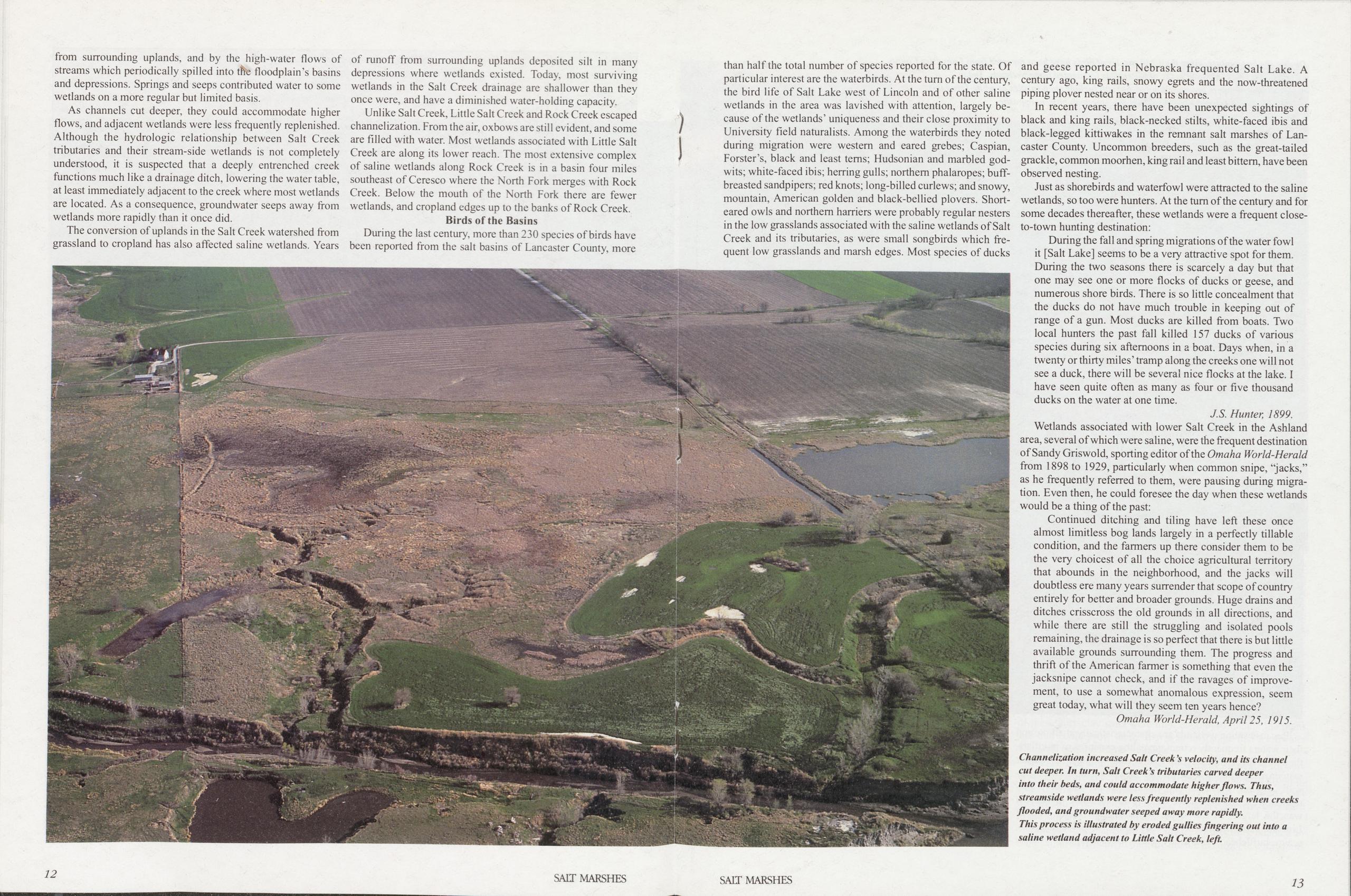
from surrounding uplands, and by the high-water flows of streams which periodically spilled into tffc floodplain’s basins and depressions. Springs and seeps contributed water to some wetlands on a more regular but limited basis.
As channels cut deeper, they could accommodate higher flows, and adjacent wetlands were less frequently replenished. Although the hydrologic relationship between Salt Creek tributaries and their stream-side wetlands is not completely understood, it is suspected that a deeply entrenched creek functions much like a drainage ditch, lowering the water table, at least immediately adjacent to the creek where most wetlands are located. As a consequence, groundwater seeps away from wetlands more rapidly than it once did.
The conversion of uplands in the Salt Creek watershed from grassland to cropland has also affected saline wetlands. Years of runoff from surrounding uplands deposited silt in many depressions where wetlands existed. Today, most surviving wetlands in the Salt Creek drainage are shallower than they once were, and have a diminished water-holding capacity. Unlike Salt Creek, Little Salt Creek and Rock Creek escaped channelization. From the air, oxbows are still evident, and some are filled with water. Most wetlands associated with Little Salt Creek are along its lower reach. The most extensive complex of saline wetlands along Rock Creek is in a basin four miles southeast of Ceresco where the North Fork merges with Rock Creek. Below the mouth of the North Fork there are fewer wetlands, and cropland edges up to the banks of Rock Creek.
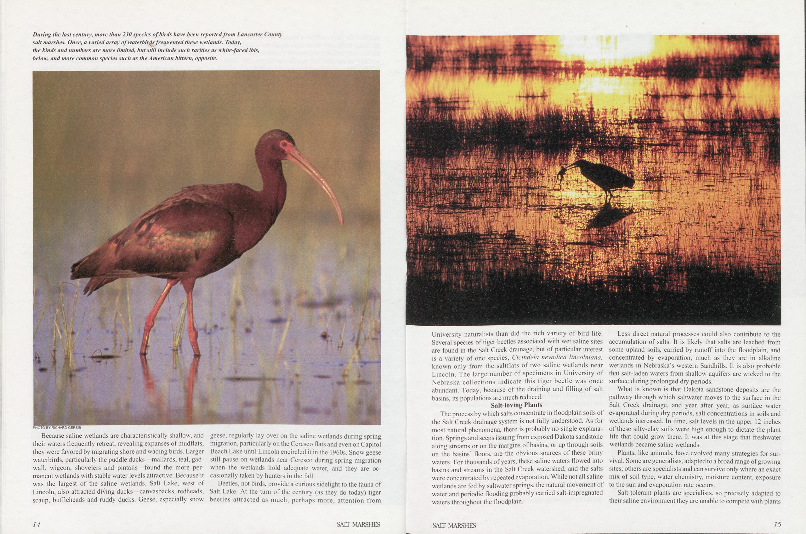
Birds of the BasinsDuring the last century, more than 230 species of birds have been reported from the salt basins of Lancaster County, more than half the total number of species reported for the state. Of particular interest are the waterbirds. At the turn of the century, the bird life of Salt Lake west of Lincoln and of other saline wetlands in the area was lavished with attention, largely because of the wetlands’ uniqueness and their close proximity to University field naturalists. Among the waterbirds they noted during migration were western and eared grebes; Caspian, Forster’s, black and least terns; Hudsonian and marbled godwits; white-faced ibis; herring gulls; northern phalaropes; buff- breasted sandpipers; red knots; long-billed curlews; and snowy, mountain, American golden and black-bellied plovers. Short-eared owls and northern harriers were probably regular nesters in the low grasslands associated with the saline wetlands of Salt Creek and its tributaries, as were small songbirds which frequent low grasslands and marsh edges. Most species of ducks and geese reported in Nebraska frequented Salt Lake. A century ago, king rails, snowy egrets and the now-threatened piping plover nested near or on its shores.
In recent years, there have been unexpected sightings of black and king rails, black-necked stilts, white-faced ibis and black-legged kittiwakes in the remnant salt marshes of Lancaster County. Uncommon breeders, such as the great-tailed grackle, common moorhen, king rail and least bittern, have been observed nesting.
Just as shorebirds and waterfowl were attracted to the saline wetlands, so too were hunters. At the turn of the century and for some decades thereafter, these wetlands were a frequent close- to-town hunting destination:
During the fall and spring migrations of the water fowl it [Salt Lake] seems to be a very attractive spot for them. During the two seasons there is scarcely a day but that one may see one or more flocks of ducks or geese, and numerous shore birds. There is so little concealment that the ducks do not have much trouble in keeping out of range of a gun. Most ducks are killed from boats. Two local hunters the past fall killed 157 ducks of various species during six afternoons in a boat. Days when, in a twenty or thirty miles’ tramp along the creeks one will not see a duck, there will be several nice flocks at the lake. I have seen quite often as many as four or five thousand ducks on the water at one time.
J.S. Hunter, 1899.Wetlands associated with lower Salt Creek in the Ashland area, several of which were saline, were the frequent destination of Sandy Griswold, sporting editor of the Omaha World-Herald from 1898 to 1929, particularly when common snipe, “jacks,” as he frequently referred to them, were pausing during migration. Even then, he could foresee the day when these wetlands would be a thing of the past:
Continued ditching and tiling have left these once almost limitless bog lands largely in a perfectly tillable condition, and the farmers up there consider them to be the very choicest of all the choice agricultural territory that abounds in the neighborhood, and the jacks will doubtless ere many years surrender that scope of country entirely for better and broader grounds. Huge drains and ditches crisscross the old grounds in all directions, and while there are still the struggling and isolated pools remaining, the drainage is so perfect that there is but little available grounds surrounding them. The progress and thrift of the American farmer is something that even the jacksnipe cannot check, and if the ravages of improvement, to use a somewhat anomalous expression, seem great today, what will they seem ten years hence? Omaha World-Herald, April 25, 1915.
Because saline wetlands are characteristically shallow, and their waters frequently retreat, revealing expanses of mudflats, they were favored by migrating shore and wading birds. Larger waterbirds, particularly the puddle ducks—mallards, teal, gadwall, wigeon, shovelers and pintails—found the more permanent wetlands with stable water levels attractive. Because it was the largest of the saline wetlands, Salt Lake, west of Lincoln, also attracted diving ducks—canvasbacks, redheads, scaup, buffleheads and ruddy ducks. Geese, especially snow geese, regularly lay over on the saline wetlands during spring migration, particularly on the Ceresco flats and even on Capitol Beach Lake until Lincoln encircled it in the 1960s. Snow geese still pause on wetlands near Ceresco during spring migration when the wetlands hold adequate water, and they are occasionally taken by hunters in the fall.
Beetles, not birds, provide a curious sidelight to the fauna of Salt Lake. At the turn of the century (as they do today) tiger beetles attracted as much, perhaps more, attention from University naturalists than did the rich variety of bird life. Several species of tiger beetles associated with wet saline sites are found in the Salt Creek drainage, but of particular interest is a variety of one species, Cicindela nevadica lincolniana, known only from the saltflats of two saline wetlands near Lincoln. The large number of specimens in University of Nebraska collections indicate this tiger beetle was once abundant. Today, because of the draining and filling of salt basins, its populations are much reduced.
Salt-loving PlantsThe process by which salts concentrate in floodplain soils of the Salt Creek drainage system is not fully understood. As for most natural phenomena, there is probably no single explanation. Springs and seeps issuing from exposed Dakota sandstone along streams or on the margins of basins, or up through soils on the basins’ floors, are the obvious sources of these briny waters. For thousands of years, these saline waters flowed into basins and streams in the Salt Creek watershed, and the salts were concentrated by repeated evaporation. While not all saline wetlands are fed by saltwater springs, the natural movement of water and periodic flooding probably carried salt-impregnated waters throughout the floodplain.
Less direct natural processes could also contribute to the accumulation of salts. It is likely that salts are leached from some upland soils, carried by runoff into the floodplain, and concentrated by evaporation, much as they are in alkaline wetlands in Nebraska’s western Sandhills. It is also probable that salt-laden waters from shallow aquifers are wicked to the surface during prolonged dry periods.
What is known is that Dakota sandstone deposits are the pathway through which saltwater moves to the surface in the Salt Creek drainage, and year after year, as surface water evaporated during dry periods, salt concentrations in soils and wetlands increased. In time, salt levels in the upper 12 inches of these silty-clay soils were high enough to dictate the plant life that could grow there. It was at this stage that freshwater wetlands became saline wetlands.
Plants, like animals, have evolved many strategies for survival . Some are generalists, adapted to a broad range of growing sites; others are specialists and can survive only where an exact mix of soil type, water chemistry, moisture content, exposure to the sun and evaporation rate occurs.
Salt-tolerant plants are specialists, so precisely adapted to their saline environment they are unable to compete with plants
14 SALT MARSHES SALT MARSHES 15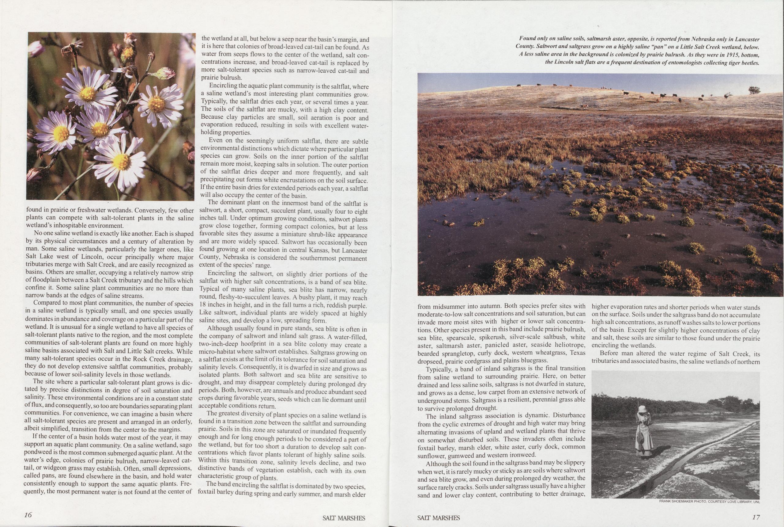
found in prairie or freshwater wetlands. Conversely, few other plants can compete with salt-tolerant plants in the saline wetland’s inhospitable environment.
No one saline wetland is exactly like another. Each is shaped by its physical circumstances and a century of alteration by man. Some saline wetlands, particularly the larger ones, like Salt Lake west of Lincoln, occur principally where major tributaries merge with Salt Creek, and are easily recognized as basins. Others are smaller, occupying a relatively narrow strip of floodplain between a Salt Creek tributary and the hills which confine it. Some saline plant communities are no more than narrow bands at the edges of saline streams.
Compared to most plant communities, the number of species in a saline wetland is typically small, and one species usually dominates in abundance and coverage on a particular part of the wetland. It is unusual for a single wetland to have all species of salt-tolerant plants native to the region, and the most complete communities of salt-tolerant plants are found on more highly saline basins associated with Salt and Little Salt creeks. While many salt-tolerant species occur in the Rock Creek drainage, they do not develop extensive saltflat communities, probably because of lower soil-salinity levels in those wetlands.
The site where a particular salt-tolerant plant grows is dictated by precise distinctions in degree of soil saturation and salinity. These environmental conditions are in a constant state of flux, and consequently, so too are boundaries separating plant communities. For convenience, we can imagine a basin where all salt-tolerant species are present and arranged in an orderly, albeit simplified, transition from the center to the margins.
If the center of a basin holds water most of the year, it may support an aquatic plant community. On a saline wetland, sago pondweed is the most common submerged aquatic plant. At the water’s edge, colonies of prairie bulrush, narrow-leaved cattail, or widgeon grass may establish. Often, small depressions, called pans, are found elsewhere in the basin, and hold water consistently enough to support the same aquatic plants. Frequently, the most permanent water is not found at the center of the wetland at all, but below a seep near the basin’s margin, and it is here that colonies of broad-leaved cat-tail can be found. As water from seeps flows to the center of the wetland, salt concentrations increase, and broad-leaved cat-tail is replaced by more salt-tolerant species such as narrow-leaved cat-tail and prairie bulrush.
Encircling the aquatic plant community is the saltflat, where a saline wetland’s most interesting plant communities grow. Typically, the saltflat dries each year, or several times a year. The soils of the saltflat are mucky, with a high clay content. Because clay particles are small, soil aeration is poor and evaporation reduced, resulting in soils with excellent water- holding properties.
Even on the seemingly uniform saltflat, there are subtle environmental distinctions which dictate where particular plant species can grow. Soils on the inner portion of the saltflat remain more moist, keeping salts in solution. The outer portion of the saltflat dries deeper and more frequently, and salt precipitating out forms white encrustations on the soil surface. If the entire basin dries for extended periods each year, a saltflat will also occupy the center of the basin.
The dominant plant on the innermost band of the saltflat is saltwort, a short, compact, succulent plant, usually four to eight inches tall. Under optimum growing conditions, saltwort plants grow close together, forming compact colonies, but at less favorable sites they assume a miniature shrub-like appearance and are more widely spaced. Saltwort has occasionally been found growing at one location in central Kansas, but Lancaster County, Nebraska is considered the southernmost permanent extent of the species’ range.
Encircling the saltwort, on slightly drier portions of the saltflat with higher salt concentrations, is a band of sea blite. Typical of many saline plants, sea blite has narrow, nearly round, fleshy-to-succulent leaves. A bushy plant, it may reach 18 inches in height, and in the fall turns a rich, reddish purple. Like saltwort, individual plants are widely spaced at highly saline sites, and develop a low, spreading form.
Although usually found in pure stands, sea blite is often in the company of saltwort and inland salt grass. A water-filled, two-inch-deep hoofprint in a sea blite colony may create a micro-habitat where saltwort establishes. Saltgrass growing on a saltflat exists at the limit of its tolerance for soil saturation and salinity levels. Consequently, it is dwarfed in size and grows as isolated plants. Both saltwort and sea blite are sensitive to drought, and may disappear completely during prolonged dry periods. Both, however, are annuals and produce abundant seed crops during favorable years, seeds which can lie dormant until acceptable conditions return.
The greatest diversity of plant species on a saline wetland is found in a transition zone between the saltflat and surrounding prairie. Soils in this zone are saturated or inundated frequently enough and for long enough periods to be considered a part of the wetland, but for too short a duration to develop salt concentrations which favor plants tolerant of highly saline soils. Within this transition zone, salinity levels decline, and two distinctive bands of vegetation establish, each with its own characteristic group of plants.
The band encircling the saltflat is dominated by two species, foxtail barley during spring and early summer, and marsh elder
from midsummer into autumn. Both species prefer sites with moderate-to-low salt concentrations and soil saturation, but can invade more moist sites with higher or lower salt concentrations. Other species present in this band include prairie bulrush, sea blite, spearscale, spikerush, silver-scale saltbush, white aster, saltmarsh aster, panicled aster, seaside heliotrope, bearded sprangletop, curly dock, western wheatgrass, Texas dropseed, prairie cordgrass and plains bluegrass.
Typically, a band of inland saltgrass is the final transition from saline wetland to surrounding prairie. Here, on better drained and less saline soils, saltgrass is not dwarfed in stature, and grows as a dense, low carpet from an extensive network of underground stems. Saltgrass is a resilient, perennial grass able to survive prolonged drought.
The inland saltgrass association is dynamic. Disturbance from the cyclic extremes of drought and high water may bring alternating invasions of upland and wetland plants that thrive on somewhat disturbed soils. These invaders often include foxtail barley, marsh elder, white aster, curly dock, common sunflower, gumweed and western ironweed.
Although the soil found in the saltgrass band may be slippery when wet, it is rarely mucky or sticky as are soils where saltwort and sea blite grow, and even during prolonged dry weather, the surface rarely cracks. Soils under saltgrass usually have a higher sand and lower clay content, contributing to better drainage, higher evaporation rates and shorter periods when water stands on the surface. Soils under the saltgrass band do not accumulate high salt concentrations, as runoff washes salts to lower portions of the basin Except for slightly higher concentrations of clay and salt, these soils are similar to those found under the prairie encircling the wetlands.
Before man altered the water regime of Salt Creek, its tributaries and associated basins, the saline wetlands of northern
16 SALT MARSHES SALT MARSHES 17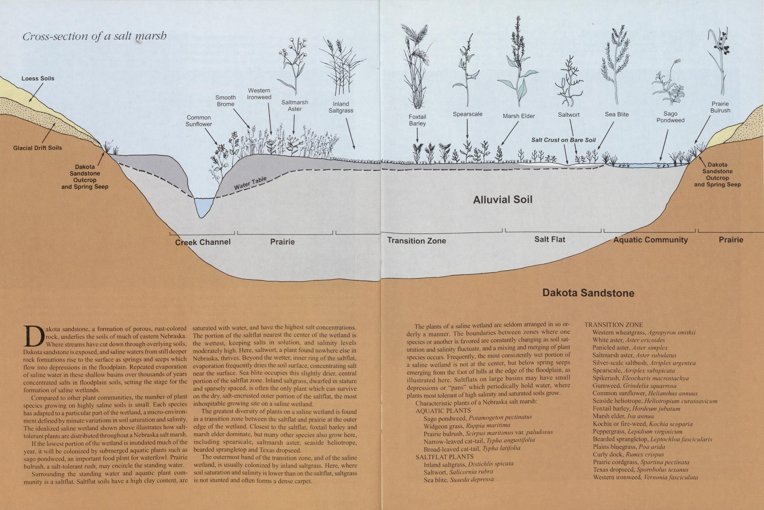
Dakota sandstone, a formation of porous, rust-colored rock, underlies the soils of much of eastern Nebraska. Where streams have cut down through overlying soils, Dakota sandstone is exposed, and saline waters from still deeper rock formations rise to the surface as springs and seeps which flow into depressions in the floodplain. Repeated evaporation of saline water in these shallow basins over thousands of years concentrated salts in floodplain soils, setting the stage for the formation of saline wetlands.
Compared to other plant communities, the number of plant species growing on highly saline soils is small. Each species has adapted to a particular part of the wetland, a micro-environment defined by minute variations in soil saturation and salinity. The idealized saline wetland shown above illustrates how salt- tolerant plants are distributed throughout a Nebraska salt marsh.
If the lowest portion of the wetland is inundated much of the year, it will be colonized by submerged aquatic plants such as sago pondweed, an important food plant for waterfowl. Prairie bulrush, a salt-tolerant rush, may encircle the standing water.
Surrounding the standing water and aquatic plant community is a saltflat. Saltflat soils have a high clay content, are saturated with water, and have the highest salt concentrations. The portion of the saltflat nearest the center of the wetland is the wettest, keeping salts in solution, and salinity levels moderately high. Here, saltwort, a plant found nowhere else in Nebraska, thrives. Beyond the wetter, inner ring of the saltflat, evaporation frequently dries the soil surface, concentrating salt near the surface. Sea blite occupies this slightly drier, central portion of the saltflat zone. Inland saltgrass, dwarfed in stature and sparsely spaced, is often the only plant which can survive on the dry, salt-encrusted outer portion of the saltflat, the most inhospitable growing site on a saline wetland.
The greatest diversity of plants on a saline wetland is found in a transition zone betw een the saltflat and prairie at the outer edge of the wetland. Closest to the saltflat, foxtail barley and marsh elder dominate, but many other species also grow here, including spearscale, saltmarsh aster, seaside heliotrope, bearded sprangletop and Texas dropseed.
The outermost band of the transition zone, and of the saline wetland, is usually colonized by inland saltgrass. Here, where soil saturation and salinity is lower than on the saltflat, saltgrass is not stunted and often forms a dense carpet.
The plants of a saline wetland are seldom arranged in so orderly a manner. The boundaries between zones where one species or another is favored are constantly changing as soil saturation and salinity fluctuate, and a mixing and merging of plant species occurs. Frequently, the most consistently wet portion of a saline wetland is not at the center, but below spring seeps emerging from the foot of hills at the edge of the floodplain, as illustrated here. Saltflats on large basins may have small depressions or "pans” which periodically hold water, where plants most tolerant of high salinity and saturated soils grow. Characteristic plants of a Nebraska salt marsh:
AQUATIC PLANTS Sago pondweed, Potamogeton pectinatus Widgeon grass, Ruppia maritimei Prairie bulrush, Scirpus maritimus var. paludosus Narrow-leaved cat-tail, Typha angustifolia Broad-leaved cat-tail, Tvpha latifolia SALTFLAT PLANTS Inland saltgrass, Distichlis spicata Saltwort, Salicornia rubra Sea blite, Suaeda depress a TRANSITION ZONE Western wheatgrass, Agropyron smithii White aster, Aster ericoides Panic led aster. Aster simplex Saltmarsh aster, Aster subulatus Silver-scale saltbush. A trip I ex argent ea Spearscale, Atriplex subspicata Spikerush, Eleocharis macros!achya Gumweed, Grindelia squarrosa Common sunflower, Heliamhus annuus Seaside heliotrope, Heliotropium curassavicum Foxtail barley, Hordeum jubatum Marsh elder, Iva annua Kochia or fire-weed, Kochia scoparia Peppergrass, Lepidium virginicum Bearded sprangletop, Leptochloa faseicularis Plains bluegrass, Poa arida Curly dock, Rumex crispus Prairie cordgrass, Spartina pectinata Texas dropsecd, Sporobolus texanus Western iron weed. Vernonia fasciculata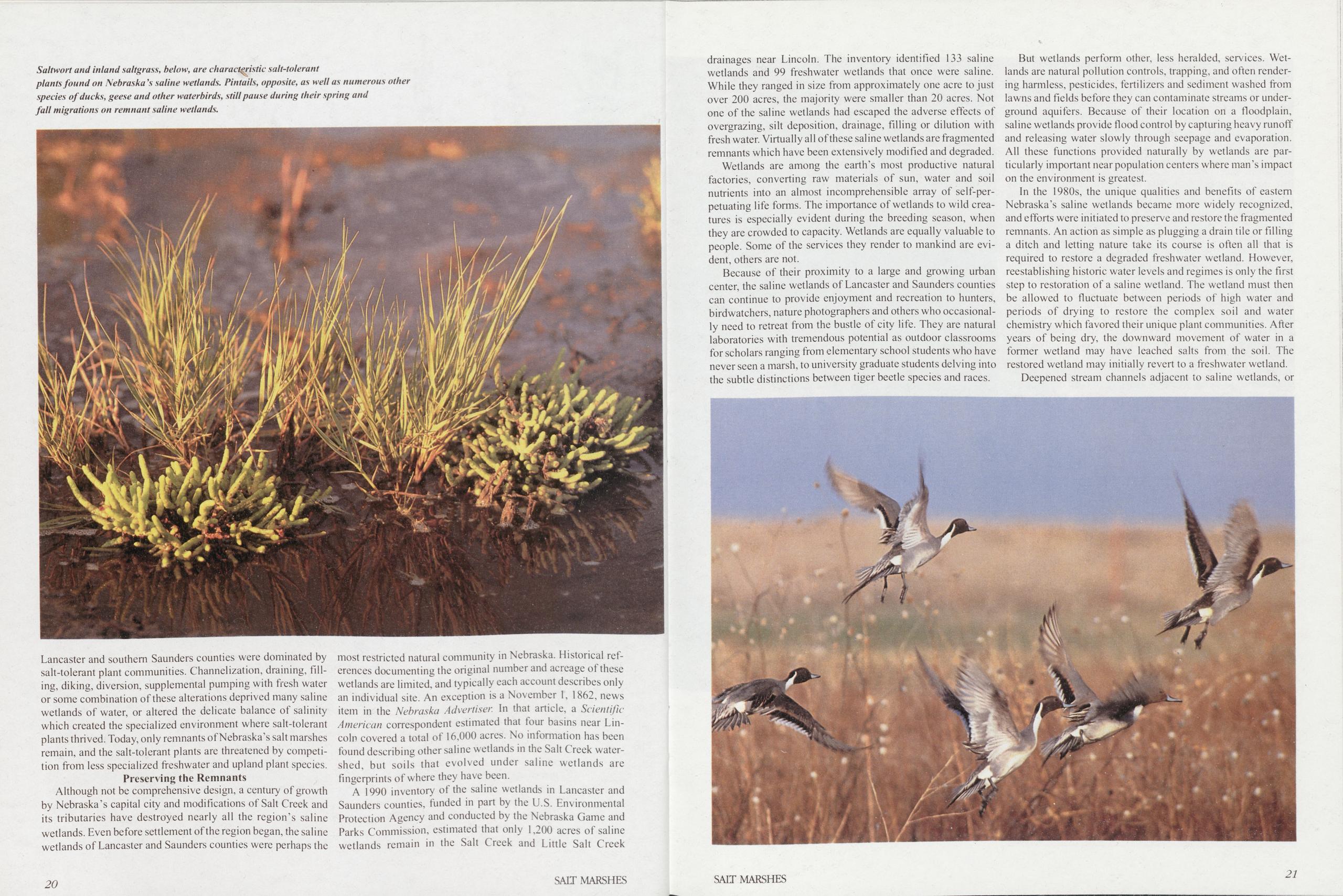
Lancaster and southern Saunders counties were dominated by salt-tolerant plant communities. Channelization, draining, filling, diking, diversion, supplemental pumping with fresh water or some combination of these alterations deprived many saline wetlands of water, or altered the delicate balance of salinity which created the specialized environment where salt-tolerant plants thrived. Today, only remnants of Nebraska’s salt marshes remain, and the salt-tolerant plants are threatened by competition from less specialized freshwater and upland plant species.
Preserving the RemnantsAlthough not be comprehensive design, a century of growth by Nebraska’s capital city and modifications of Salt Creek and its tributaries have destroyed nearly all the region’s saline wetlands. Even before settlement of the region began, the saline wetlands of Lancaster and Saunders counties were perhaps the
20most restricted natural community in Nebraska. Historical references documenting the original number and acreage of these wetlands are limited, and typically each account describes only an individual site. An exception is a November 1, 1862, news item in the Nebraska Advertiser In that article, a Scientific American correspondent estimated that four basins near Lincoln covered a total of 16,000 acres. No information has been found describing other saline wetlands in the Salt Creek watershed, but soils that evolved under saline wetlands are fingerprints of where they have been.
A 1990 inventory of the saline wetlands in Lancaster and Saunders counties, funded in part by the U.S. Environmental Protection Agency and conducted by the Nebraska Game and Parks Commission, estimated that only 1,200 acres of saline wetlands remain in the Salt Creek and Little Salt Creek SALT MARSHES drainages near Lincoln. The inventory identified 133 saline wetlands and 99 freshwater wetlands that once were saline. While they ranged in size from approximately one acre to just over 200 acres, the majority were smaller than 20 acres. Not one of the saline wetlands had escaped the adverse effects of overgrazing, silt deposition, drainage, filling or dilution with fresh water. Virtually all of these saline wetlands are fragmented remnants which have been extensively modified and degraded.
Wetlands are among the earth’s most productive natural factories, converting raw materials of sun, water and soil nutrients into an almost incomprehensible array of self-perpetuating life forms. The importance of wetlands to wild crea- tures is especially evident during the breeding season, when they are crowded to capacity. Wetlands are equally valuable to people. Some of the services they render to mankind are evident, others are not.
Because of their proximity to a large and growing urban center, the saline wetlands of Lancaster and Saunders counties can continue to provide enjoyment and recreation to hunters, birdwatchers, nature photographers and others who occasionally need to retreat from the bustle of city life. They are natural laboratories with tremendous potential as outdoor classrooms for scholars ranging from elementary school students who have never seen a marsh, to university graduate students delving into the subtle distinctions between tiger beetle species and races.
SALT MARSHESBut wetlands perform other, less heralded, services. Wetlands are natural pollution controls, trapping, and often render- ing harmless, pesticides, fertilizers and sediment washed from lawns and fields before they can contaminate streams or underground aquifers. Because of their location on a floodplain, saline wetlands provide flood control by capturing heavy runoff and releasing water slowly through seepage and evaporation. All these functions provided naturally by wetlands are particularly important near population centers where man’s impact on the environment is greatest.
In the 1980s, the unique qualities and benefits of eastern Nebraska’s saline wetlands became more widely recognized, and efforts were initiated to preserve and restore the fragmented remnants. An action as simple as plugging a drain tile or filling a ditch and letting nature take its course is often all that is required to restore a degraded freshwater wetland. However, reestablishing historic water levels and regimes is only the first step to restoration of a saline wetland. The wetland must then be allowed to fluctuate between periods of high water and periods of drying to restore the complex soil and water chemistry which favored their unique plant communities. After years of being dry, the downward movement of water in a former wetland may have leached salts from the soil. The restored wetland may initially revert to a freshwater wetland. Deepened stream channels adjacent to saline wetlands, or
21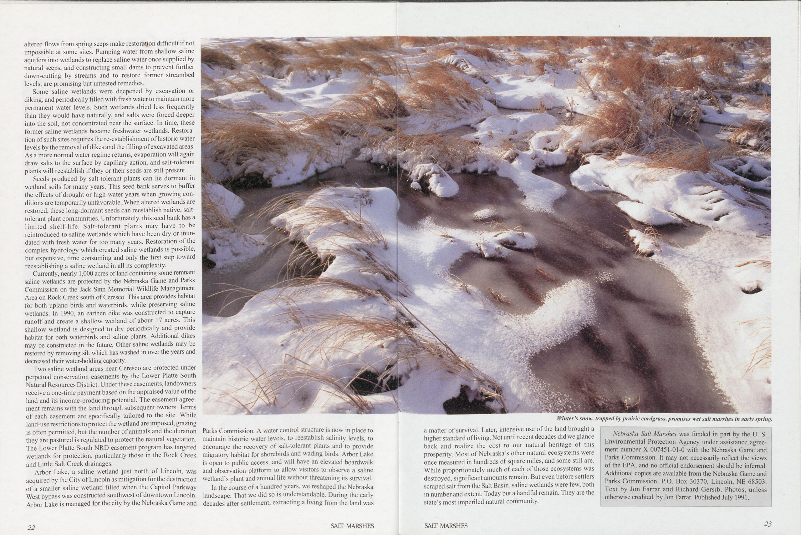
altered flows from spring seeps make restoration difficult if not impossible at some sites. Pumping water from shallow saline aquifers into wetlands to replace saline water once supplied by natural seeps, and constructing small dams to prevent further down-cutting by streams and to restore former streambed levels, are promising but untested remedies.
Some saline wetlands were deepened by excavation or diking, and periodically filled with fresh water to maintain more permanent water levels. Such wetlands dried less frequently than they would have naturally, and salts were forced deeper into the soil, not concentrated near the surface. In time, these former saline wetlands became freshwater wetlands. Restoration of such sites requires the re-establishment of historic water levels by the removal of dikes and the filling of excavated areas. As a more normal water regime returns, evaporation will again draw salts to the surface by capillary action, and salt-tolerant plants will reestablish if they or their seeds are still present. Seeds produced by salt-tolerant plants can lie dormant in wetland soils for many years. This seed bank serves to buffer the effects of drought or high-water years when growing conditions are temporarily unfavorable., When altered wetlands are restored, these long-dormant seeds can reestablish native, salt-tolerant plant communities. Unfortunately, this seed bank has a limited shelf-life. Salt-tolerant plants may have to be reintroduced to saline wetlands which have been dry or inundated with fresh water for too many years. Restoration of the complex hydrology which created saline wetlands is possible, but expensive, time consuming and only the first step toward reestablishing a saline wetland in all its complexity.
Currently, nearly 1,000 acres of land containing some remnant saline wetlands are protected by the Nebraska Game and Parks Commission on the Jack Sinn Memorial Wildlife Management Area on Rock Creek south of Ceresco. This area provides habitat for both upland birds and waterbirds, while preserving saline wetlands. In 1990, an earthen dike was constructed to capture runoff and create a shallow wetland of about 17 acres. This shallow wetland is designed to dry periodically and provide habitat for both waterbirds and saline plants. Additional dikes may be constructed in the future. Other saline wetlands may be restored by removing silt which has washed in over the years and decreased their water-holding capacity.
Two saline wetland areas near Ceresco are protected under perpetual conservation easements by the Lower Platte South Natural Resources District. Under these easements, landowners receive a one-time payment based on the appraised value of the land and its income-producing potential. The easement agreement remains with the land through subsequent owners. Terms of each easement are specifically tailored to the site. While land-use restrictions to protect the wetland are imposed, grazing is often permitted, but the number of animals and the duration they are pastured is regulated to protect the natural vegetation. The Lower Platte South NRD easement program has targeted wetlands for protection, particularly those in the Rock Creek and Little Salt Creek drainages.
Arbor Lake, a saline wetland just north of Lincoln, was acquired by the City of Lincoln as mitigation for the destruction of a smaller saline wetland filled when the Capitol Parkway West bypass was constructed southwest of downtown Lincoln. Arbor Lake is managed for the city by the Nebraska Game and Parks Commission. A water control structure is now in place to maintain historic water levels, to reestablish salinity levels, to encourage the recovery of salt-tolerant plants and to provide migratory habitat for shorebirds and wading birds. Arbor Lake is open to public access, and will have an elevated boardwalk and observation platform to allow visitors to observe a saline wetland’s plant and animal life without threatening its survival.
In the course of a hundred years, we reshaped the Nebraska landscape. That we did so is understandable. During the early decades after settlement, extracting a living from the land was a matter of survival. Later, intensive use of the land brought a higher standard of living. Not until recent decades did we glance back and realize the cost to our natural heritage of this prosperity. Most of Nebraska’s other natural ecosystems were once measured in hundreds of square miles, and some still are.
While proportionately much of each of those ecosystems was destroyed, significant amounts remain. But even before settlers scraped salt from the Salt Basin, saline wetlands were few, both in number and extent. Today but a handful remain. They are the state’s most imperiled natural community.
Nebraska Salt Marshes was funded in part by the U. S. Environmental Protection Agency under assistance agreement number X 007451-01-0 with the Nebraska Game and Parks Commission. It may not necessarily reflect the views of the EPA, and no official endorsement should be inferred.
Additional copies are available from the Nebraska Game and Parks Commission, P.O. Box 30370, Lincoln, NE 68503. Text by Jon Farrar and Richard Gersib. Photos, unless otherwise credited, by Jon Farrar. Published July 1991.Winter's snow, trapped by prairie cordgrass, promises wet salt marshes in early spring.
Seeing Red
Photo and Text by Jon FarrarSpring days lengthen, and hormones surge through the bird world. Calls waft across grasslands, through woods and over marshes. Some birdcalls are sweet and melodious, some guttural and to the point. Whatever its musical quality, each birdcall evolved to communicate a message, and throughout the breeding season, one message is issued more often than any other. Humans put up fences and signs to define the boundaries of their territories; birds gracefully accomplish the same end with song and display. Of all the bird species found in Nebraska, few draw more attention to themselves than does the ubiquitous red-winged blackbird. In the breeding season, the male redwing’s plumage is dramatic—neither gaudy nor drab, nor any variation between those extremes, but rather a denomination of its own. It is as if the male’s somber black dress exists only as a backdrop, so its reddish-orange shoulder patches will blaze all the more brilliantly.
The degree of conspicuousness of the shoulder patch is a barometer of the male’s emotional state, signalling his intentions to neighboring redwings, both male and female, as clearly as a semaphore. When away from its nesting territory, when resting, when feeding in the company of other male redwings or when alarmed by potential predators, the male’s shoulder patch is tucked away under a cover of black feathers, or shows only as a buffy-yellow stripe topped with a narrow band of red. Concealing the shoulder patch is the male redwing’s way of saying "I’m not looking for trouble.” But when a male redwing is standing guard over his territory, the shoulder patch is seldom out of sight.
Nineteenth century naturalist Thomas Nuttall described the redwing’s song as "something betwixt chattering warbling—jingling liquid notes ... then complaining chirps, jars and sounds like saw-filing, or the motion of a sign-board on its rusty hinge; the whole constituting a novel and sometimes grand chorus of discord and harmony, in which the performers seem in good earnest, and bristle up their feathers as if inclined at least to make up in quantity what their show of music may lack in quality.”
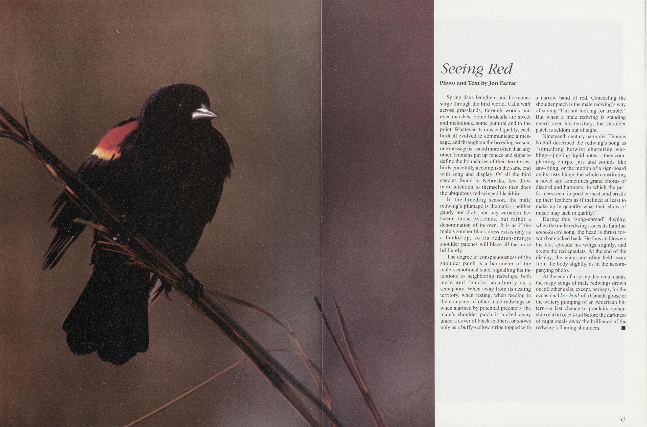
During this "song-spread” display, when the male redwing issues its familiar konk-ka-ree song, the head is thrust for- ward or cocked back. He fans and lowers his tail, spreads his wings slightly, and erects the red epaulets. At the end of the display, the wings are often held away from the body slightly, as in the accom- panying photo.
At the end of a spring day on a marsh, the raspy songs of male redwings drown out all other calls, except, perhaps, for the occasional ker-honk of a Canada goose or the watery pumping of an American bittern—a last chance to proclaim ownership of a bit of cat-tail before the darkness of night steals away the brilliance of the redwing’s flaming shoulders.
43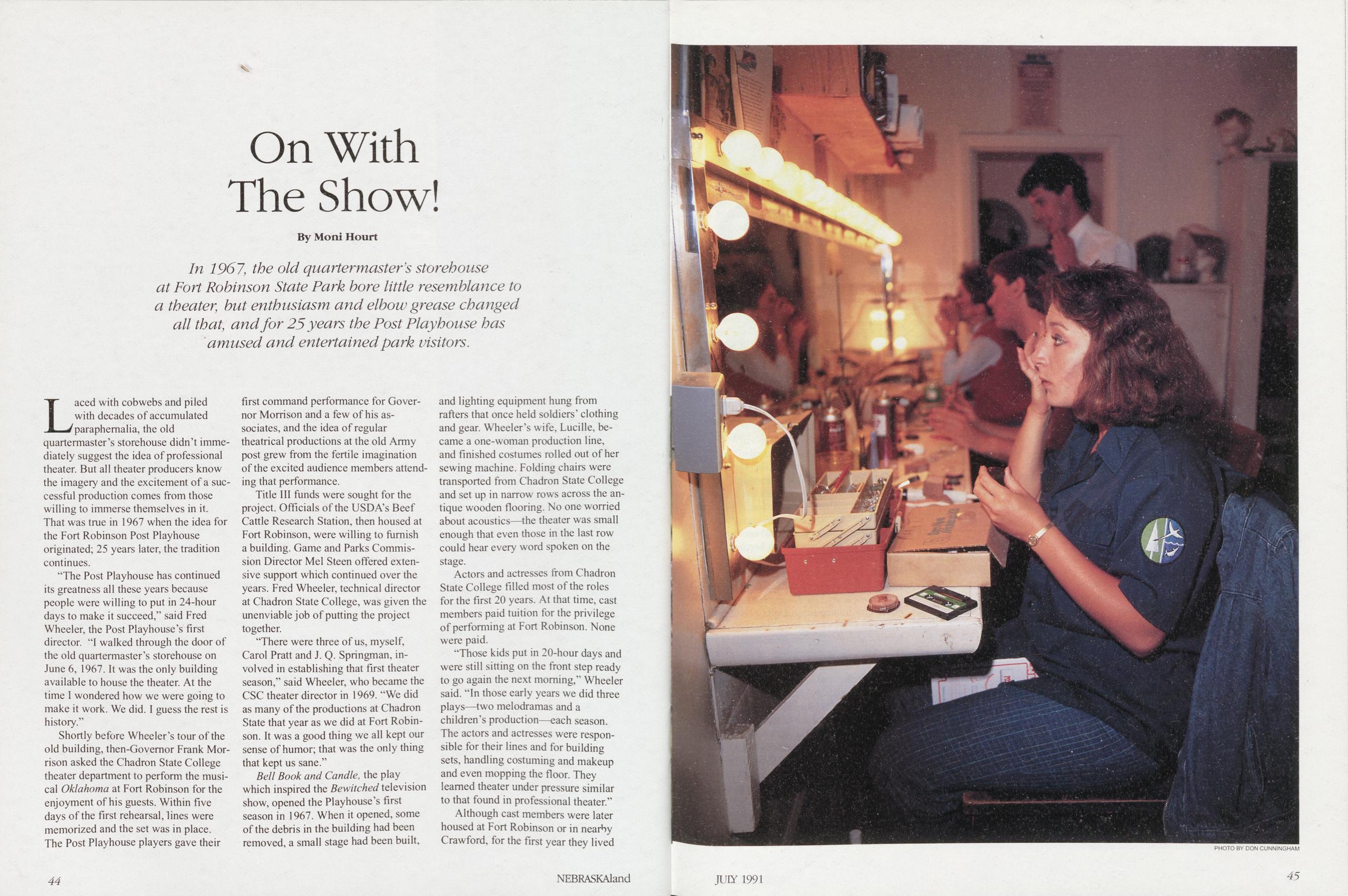
On With The Show!
By Moni Hourt In 1967, the old quartermaster’s storehouse at Fort Robinson State Park bore little resemblance to a theater, but enthusiasm and elbow grease changed all that, and for 25 years the Post Playhouse has amused and entertained park visitors.Laced with cobwebs and piled with decades of accumulated paraphernalia, the old quartermaster’s storehouse didn’t immediately suggest the idea of professional theater. But all theater producers know the imagery and the excitement of a successful production comes from those willing to immerse themselves in it. That was true in 1967 when the idea for the Fort Robinson Post Playhouse originated; 25 years later, the tradition continues.
“The Post Playhouse has continued its greatness all these years because people were willing to put in 24-hour days to make it succeed,” said Fred Wheeler, the Post Playhouse’s first director. “I walked through the door of the old quartermaster’s storehouse on June 6, 1967. It was the only building available to house the theater. At the time I wondered how we were going to make it work. We did. I guess the rest is history.”
Shortly before Wheeler’s tour of the old building, then-Govemor Frank Morrison asked the Chadron State College theater department to perform the musical Oklahoma at Fort Robinson for the enjoyment of his guests. Within five days of the first rehearsal, lines were memorized and the set was in place. The Post Playhouse players gave their first command performance for Governor Morrison and a few of his associates, and the idea of regular theatrical productions at the old Army post grew from the fertile imagination of the excited audience members attending that performance.
Title III funds were sought for the project. Officials of the USDA’s Beef Cattle Research Station, then housed at Fort Robinson, were willing to furnish a building. Game and Parks Commission Director Mel Steen offered extensive support which continued over the years. Fred Wheeler, technical director at Chadron State College, was given the unenviable job of putting the project together.
“There were three of us, myself, Carol Pratt and J. Q. Springman, involved in establishing that first theater season,” said Wheeler, who became the CSC theater director in 1969. “We did as many of the productions at Chadron State that year as we did at Fort Robinson. It was a good thing we all kept our sense of humor; that was the only thing that kept us sane.”
Bell Book and Candle, the play which inspired the Bewitched television show, opened the Playhouse’s first season in 1967. When it opened, some of the debris in the building had been removed, a small stage had been built, and lighting equipment hung from rafters that once held soldiers’ clothing and gear. Wheeler’s wife, Lucille, became a one-woman production line, and finished costumes rolled out of her sewing machine. Folding chairs were transported from Chadron State College and set up in narrow rows across the antique wooden flooring. No one worried about acoustics—the theater was small enough that even those in the last row could hear every word spoken on the stage.
Actors and actresses from Chadron State College filled most of the roles for the first 20 years. At that time, cast members paid tuition for the privilege of performing at Fort Robinson. None were paid.
“Those kids put in 20-hour days and were still sitting on the front step ready to go again the next morning,” Wheeler said. “In those early years we did three plays—two melodramas and a children’s production—each season. The actors and actresses were responsible for their lines and for building sets, handling costuming and makeup and even mopping the floor. They learned theater under pressure similar to that found in professional theater.”
Although cast members were later housed at Fort Robinson or in nearby Crawford, for the first year they lived
PHOTO BY DON CUNNINGHAM 44 NEBRASKAland JUIY 1991 45
on the college campus and drove the 25 miles to Fort Robinson for performances. Sets for each production made the same journey in uncovered trucks. Under normal circumstances the transportation problems would not have been excessive; however, during June 1967, western Nebraska received 15 inches of rain.
“Every morning I’d wake up and hear the rain sliding off the roof and wonder how we were going to get the sets from one place to the other,” remarked Wheeler. “We’d try to do it when it wasn’t raining. We were successful part of the time, and surprisingly enough, we worked through every problem that came our way.”
The company staged as many as four productions a day. The children’s shows were presented at all 25 Panhandle libraries. The cast might present the children’s play at three different locations, then, if an evening performance was scheduled at the fort, return there and get ready for the evening show. On easy days, they were only required to present the children’s show at three locations. By the end of the season, the young actors and actresses were on their way to becoming seasoned professionals.
“We’ve always had outstanding people to work with,” continued Wheeler. “For the 1979 season, we expanded our production schedule to include five shows plus a children’s show.
All the actors and actresses were Chadron State College students. Then we expanded the scope of our recruitment. Those kids lived together, worked together and fought together for seven days a week, 24 hours a day. I look back and find it amazing that we had very few bad apples in that bunch.”
Numerous Fort Robinson players have gone on to become theater managers at high schools and colleges across the country. Others have become professional actors, among them Wes Mann, recruited by Wheeler when a junior in high school, and currently appearing in Hollywood productions; Don Sherill, now performing in professional opera productions and John Blinde, an announcer for Voice of America radio broadcasts.
Wheeler’s own children were all involved in the early productions. The relationship between director and related cast members never created a problem. If there was any yelling to be done, says Wheeler, he’d make sure his children received the first blast of “slightly stiffened” instruction. For the first two years, the Playhouse subsisted on federal aid.
Within two years, however, it became self-sufficient. “We figured we’d better be able to pay for ourselves,” Wheeler said. “Before long most of our performances were sold out. That trend has continued through the years.”
A wide variety of productions was scheduled at the Playhouse. Musicals, including My Fair Lady and Lil ’Abner played at Fort Robinson, then toured the Panhandle area. Mysteries, dramas and comedies all marched across the Fort Rob stage, but the most popular productions have been the melodramas.
“The melodramas have always been fun to do and are well received by our audiences,” Wheeler said. “However, some of the melodramas were pretty short. We always wanted to make sure the audience received a full measure of entertainment for their ticket price. Most of the time we designed an olio, (a vaudeville-type production) to be presented between the melodrama acts.
The olios showed off some of our actors’ and actresses’ individual talents and also enhanced the productions.” Melodramas always encouraged audience participation, but the practice of throwing peanuts at the villain was discontinued after audience members complained that they were often the recipient of ill-aimed missiles.
To add to the ambience, the melodramas were accented with an old-fashioned olio backdrop, a curtain featuring advertisements from area businesses lowered between acts, a forerunner of radio and television advertising.
For several years, Upward Bound students visiting Fort Robinson were pressed into service for Historical pageants. Playhouse players were also summoned to produce special plays for the 1976 U.S. Bicentennial season.
Wheeler stepped down as director of the Playhouse in 1983, and handed the reins to John Purvey, a speech instructor at Chadron State College. Purvey made his first appearance as an actor in 1970, and returned in the same capacity two more years before becoming co-director of the Playhouse in 1984. He served as full-time director, technical director and producer in 1985.
Purvey’s successor, Jerry O’Connor, brought an equally impressive list of credentials when he became the Artistic/Managing Director of the Playhouse. Currently an instructor at an Omaha high school, O’Connor co-authored a children’s musical play, Lion s Tail, which has been produced at Fort Robinson. Aside from managing the business operations of the Playhouse, O’Connor is the artistic director of a majority of the plays.
“Productions like those at Fort Robinson depend on dedication and drive from all those involved,” Wheeler said. “We have never had a shortage of that quality. We’ve become a part of the history at Fort Robinson. We’re leaving our imprint, our spirit in the walls. We’ve left part of ourselves behind in the woodwork.”
Renovating The Playhouse
by Jerry O’Connor, Post Playhouse DirectorThanks to the LB309 task force and the Nebraska Game and Parks Commission, “This Old House” is getting a structural and atmospheric upgrading. During the summer of 1987, the seeds of hope were planted when then-State Senator Sandy Scofield took a special interest in the well-being of the Post Playhouse. While wheels were beginning to turn in the capitol, we began investigating the possibilities of major improvements for the Playhouse facility. An architectural firm was selected to do a feasibility study, and a few weeks later, the study was completed, and former Governor Kay Orr’s LB309 Task Force, led by Pete Peterson, paid a visit to the Post Playhouse.
In June of 1989, the task force allotted $150,000 to the playhouse renovation project, and it was on its way. Almost immediately, the Nebraska Game and Parks Commission, under the direction of Rex Amack, and aided by Chief of State Parks, Charles Duncan, set out to retain a project architect. The firm of Berrgren and Woll Architects, of Lincoln, was selected, and the renovation has begun. Already, new dressing rooms and a costume shop in the southeast wing have been completed.
Once completed, the renovated theater will have a spacious new lobby housing the office, concessions booth and handicap-accessible restrooms. The nave of the theater will have newly restored flip-up seats surrounded by a completely renovated inner structure. Technical changes will include enclosed electrical lighting banks above the audience as well as above the stage, and along with the lighting, a new sound system will enhance the audio qualities of the productions.
Structurally, the stage will gain about two and a half feet in height with a partially open fly area above the stage. A new space will be added to stage left, allowing for the use of scene wagons and added set-storage facilities. And, yes, to top it off, there will be air conditioning in the summer and heat in the winter. The future of the Post Playhouse, aside from the current renovation, is exciting. Most operations have always been the responsibility of one person— the Artistic/Managing Director. In the future, the playhouse will incorporate as a non-profit business under the guidance and management of a board of directors. The Post Playhouse has always provided high quality live theater to tourists and residents of the Nebraska Panhandle. We hope that the management and atmospheric changes in the theater will enhance the artistic quality.
Finally, a heartfelt thank you to all who have contributed to the restoration project and to those who may offer their support to phase four of the renovation/restoration, including the furnishing of our scene shop and other necessities.
JULY 1991 47 46 NEBRASKAland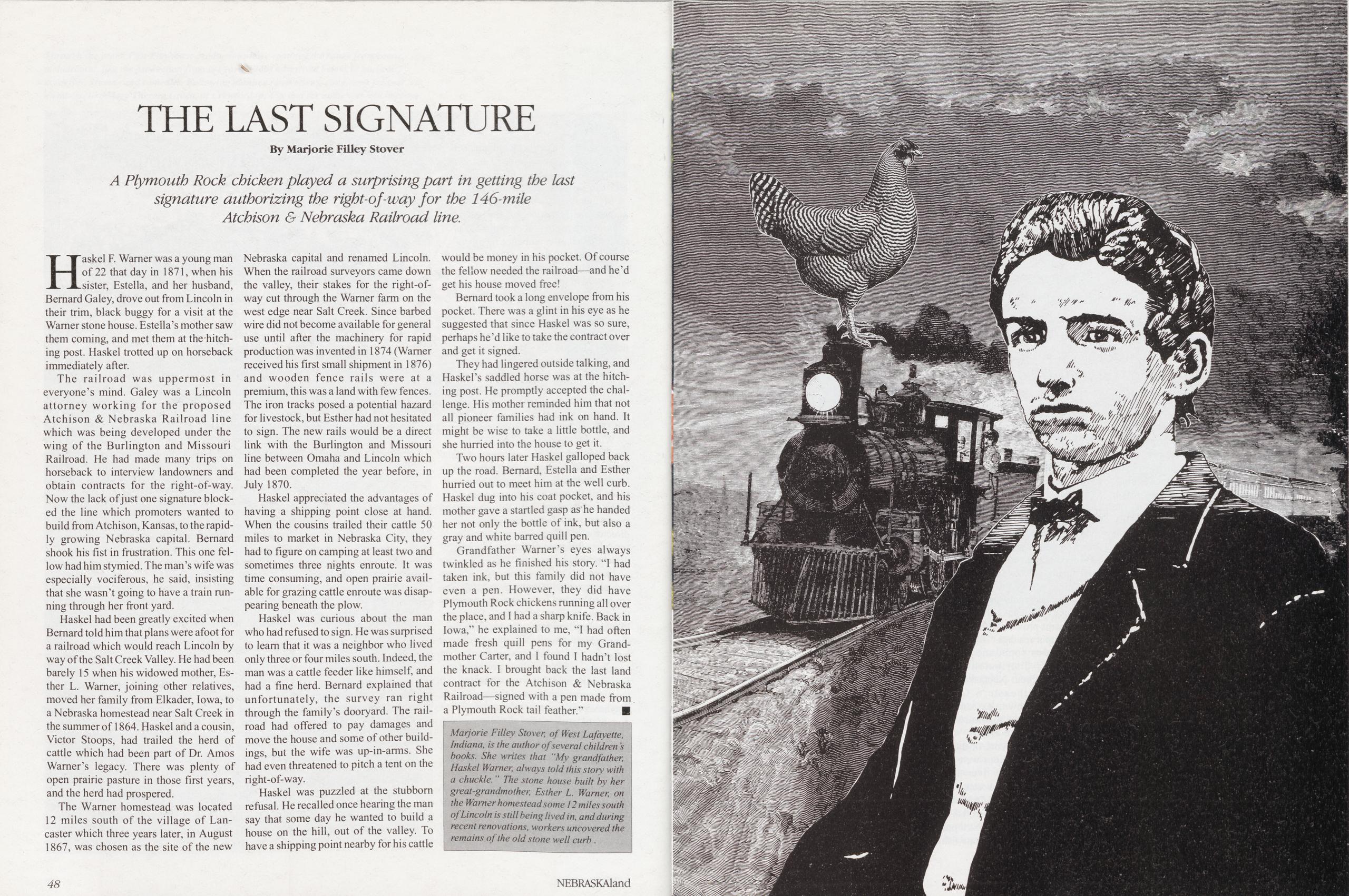
THE LAST SIGNATURE
By Marjorie Filley Stover A Plymouth Rock chicken played a surprising part in getting the last signature authorizing the right-of-way for the 146-mile Atchison & Nebraska Railroad line.Haskel F. Warner was a young man of 22 that day in 1871, when his sister, Estella, and her husband, Bernard Galey, drove out from Lincoln in their trim, black buggy for a visit at the Warner stone house. Esteila’s mother saw them coming, and met them at the hitching post. Haskel trotted up on horseback immediately after.
The railroad was uppermost in everyone’s mind. Galey was a Lincoln attorney working for the proposed Atchison & Nebraska Railroad line which was being developed under the wing of the Burlington and Missouri Railroad. He had made many trips on horseback to interview landowners and obtain contracts for the right-of-way. Now the lack of just one signature blocked the line which promoters wanted to build from Atchison, Kansas, to the rapidly growing Nebraska capital. Bernard shook his fist in frustration. This one fellow had him stymied. The man’s wife was especially vociferous, he said, insisting that she wasn’t going to have a train running through her front yard.
Haskel had been greatly excited when Bernard told him that plans were afoot for a railroad which would reach Lincoln by way of the Salt Creek Valley. He had been barely 15 when his widowed mother, Esther L. Warner, joining other relatives, moved her family from Elkader, Iowa, to a Nebraska homestead near Salt Creek in the summer of 1864. Haskel and a cousin, Victor Stoops, had trailed the herd of cattle which had been part of Dr. Amos Warner’s legacy. There was plenty of open prairie pasture in those first years, and the herd had prospered.
The Warner homestead was located 12 miles south of the village of Lancaster which three years later, in August 1867, was chosen as the site of the new Nebraska capital and renamed Lincoln. When the railroad surveyors came down the valley, their stakes for the right-of- way cut through the Warner farm on the west edge near Salt Creek. Since barbed wire did not become available for general use until after the machinery for rapid production was invented in 1874 (Warner received his first small shipment in 1876) and wooden fence rails were at a premium, this was a land with few fences. The iron tracks posed a potential hazard for livestock, but Esther had not hesitated to sign. The new rails would be a direct link with the Burlington and Missouri line between Omaha and Lincoln which had been completed the year before, in July 1870.
Haskel appreciated the advantages of having a shipping point close at hand. When the cousins trailed their cattle 50 miles to market in Nebraska City, they had to figure on camping at least two and sometimes three nights enroute. It was time consuming, and open prairie available for grazing cattle enroute was disappearing beneath the plow.
Haskel was curious about the man who had refused to sign. He was surprised to learn that it was a neighbor who lived only three or four miles south. Indeed, the man was a cattle feeder like himself, and had a fine herd. Bernard explained that unfortunately, the survey ran right through the family’s dooryard. The railroad had offered to pay damages and move the house and some of other buildings, but the wife was up-in-arms. She had even threatened to pitch a tent on the right-of-way.
Haskel was puzzled at the stubborn refusal. He recalled once hearing the man say that some day he wanted to build a house on the hill, out of the valley. To have a shipping point nearby for his cattle would be money in his pocket. Of course the fellow needed the railroad—and he’d get his house moved free! Bernard took a long envelope from his pocket. There was a glint in his eye as he suggested that since Haskel was so sure, perhaps he’d like to take the contract over and get it signed.
They had lingered outside talking, and Haskel’s saddled horse was at the hitching post. He promptly accepted the challenge. His mother reminded him that not all pioneer families had ink on hand. It might be wise to take a little bottle, and she hurried into the house to get it.
Two hours later Haskel galloped back up the road. Bernard, Estella and Esther hurried out to meet him at the well curb. Haskel dug into his coat pocket, and his mother gave a startled gasp as he handed her not only the bottle of ink, but also a gray and white barred quill pen.
Grandfather Warner’s eyes always twinkled as he finished his story. "I had taken ink, but this family did not have even a pen. However, they did have Plymouth Rock chickens running all over the place, and I had a sharp knife. Back in Iowa,” he explained to me, "I had often made fresh quill pens for my Grandmother Carter, and I found I hadn’t lost the knack. I brought back the last land contract for the Atchison & Nebraska Railroad—signed with a pen made from a Plymouth Rock tail feather.” ■
Marjorie Filley Stover, of West Lafayette, Indiana, is the author of several children s books. She writes that 11 My grandfather, Haskel Warner, always told this storv with a chuckle. " The stone house built by her great-grandmother, Esther L. Warner, on the Warner homestead some 12 miles south of Lincoln is still being lived in, and during recent renovations, workers uncovered the remains of the old stone well curb . 48 NEBRASKAland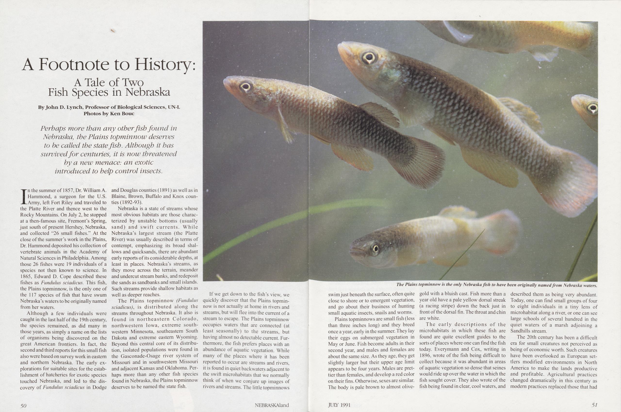
A Footnote to History: A Tale of Two Fish Species in Nebraska
By John D. Lynch, Professor of Biological Sciences, UN-LPhotos by Ken Bouc Perhaps more than any other fish found in Nebraska, the Plains topminnow deserves to be called the state fish. Although it has survived for centuries, it is now threatened by a new menace: an exotic introduced to help control insects.
In the summer of 1857, Dr. William A. Hammond, a surgeon for the U.S. Army, left Fort Riley and traveled to the Platte River and thence west to the Rocky Mountains. On July 2, he stopped at a then-famous site, Fremont’s Spring, just south of present Hershey, Nebraska, and collected "26 small fishes.” At the close of the summer’s work in the Plains, Dr. Hammond deposited his collection of vertebrate animals in the Academy of Natural Sciences in Philadelphia. Among those 26 fishes were 19 individuals of a species not then known to science. In 1865, Edward D. Cope described these fishes as Fundulus sciadicus. This fish, the Plains topminnow, is the only one of the 117 species of fish that have swum Nebraska’s waters to be originally named from her waters.
Although a few individuals were caught in the last half of the 19th century, the species remained, as did many in those years, as simply a name on the lists of organisms being discovered on the great American frontiers. In fact, the second and third reports for this small fish also were based on survey work in eastern and northern Nebraska. The early explorations for suitable sites for the establishment of hatcheries for exotic species touched Nebraska, and led to the discovery of Fundulus sciadicus in Dodge and Douglas counties (1891) as well as in Blaine, Brown, Buffalo and Knox counties (1892-93).
Nebraska is a state of streams whose most obvious habitats are those characterized by unstable bottoms (usually sand) and swift currents. While Nebraska’s largest stream (the Platte River) was usually described in terms of contempt, emphasizing its broad shallows and quicksands, there are abundant early reports of its considerable depths, at least in places. Nebraska’s streams, as they move across the terrain, meander and undercut stream banks, and redeposit the sands as sandbanks and small islands. Such streams provide shallow habitats as well as deeper reaches.
The Plains topminnow (Fundulus sciadicus), is distributed along the streams throughout Nebraska. It also is found in northeastern Colorado, northwestern Iowa, extreme southwestern Minnesota, southeastern South Dakota and extreme eastern Wyoming. Beyond this central core of its distribution, isolated populations were found in the Gasconade-Osage river system of Missouri and in southwestern Missouri and adjacent Kansas and Oklahoma. Perhaps more than any other fish species found in Nebraska, the Plains topminnow deserves to be named the state fish.
If we get down to the fish’s view, we quickly discover that the Plains topminnow is not actually at home in rivers and streams, but will flee into the current of a stream to escape. The Plains topminnow occupies waters that are connected (at least seasonally) to the streams, but having almost no detectable current. Furthermore, the fish prefers places with an abundance of aquatic vegetation. While many of the places where it has been reported to occur are streams and rivers, it is found in quiet backwaters adjacent to the swift microhabitats that we normally think of when we conjure up images of rivers and streams. The little topminnows
swim just beneath the surface, often quite close to shore or to emergent vegetation, and go about their business of hunting small aquatic insects, snails and worms.
Plains topminnows are small fish (less than three inches long) and they breed once a year, early in the summer. They lay their eggs on submerged vegetation in May or June. Fish become adults in their second year, and males and females are about the same size. As they age, they get slightly larger but their upper age limit appears to be four years. Males are prettier than females, and develop a red color on their fins. Otherwise, sexes are similar. The body is pale brown to almost olive-gold with a bluish cast. Fish more than a year old have a pale yellow dorsal streak (a racing stripe) down the back just in front of the dorsal fin. The throat and chin are white.
The early descriptions of the microhabitats in which these fish are found are quite excellent guides to the sorts of places where one can find the fish today. Everymann and Cox, writing in 1896, wrote of the fish being difficult to collect because it was abundant in areas of aquatic vegetation so dense that seines would ride up over the water in which the fish sought cover. They also wrote of the fish being found in clear, cool waters, and described them as being very abundant. Today, one can find small groups of four to eight individuals in a tiny lens of microhabitat along a river, or one can see large schools of several hundred in the quiet waters of a marsh adjoining a Sandhills stream.
The 20th century has been a difficult era for small creatures not perceived as being of economic worth. Such creatures have been overlooked as European settlers modified environments in North America to make the lands productive and profitable. Agricultural practices changed dramatically in this century as modem practices replaced those that had
50 NEBRASKAland JULY 1991 51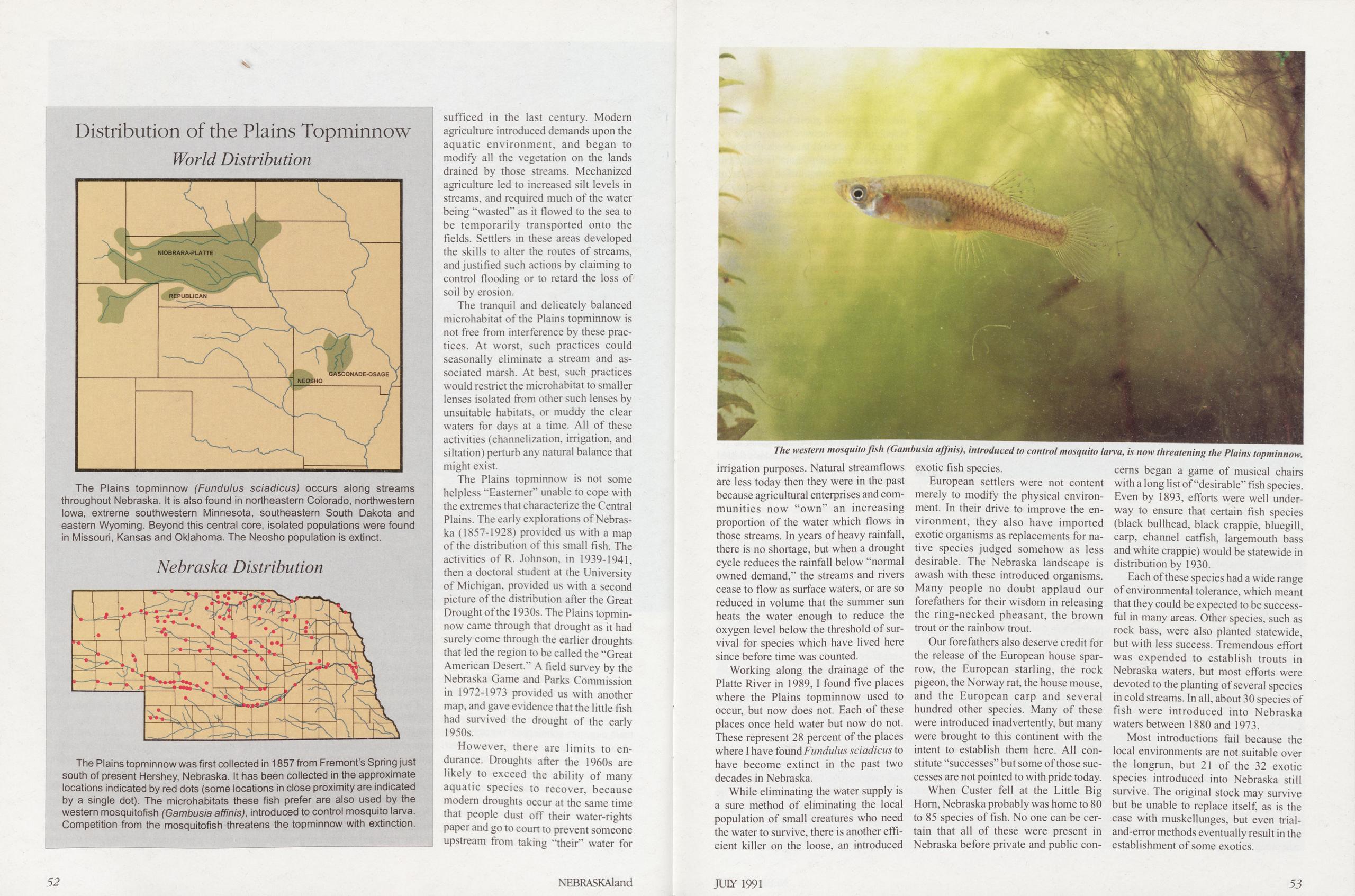 Distribution of the Plains Topminnow
World Distribution
Distribution of the Plains Topminnow
World Distribution
sufficed in the last century. Modem agriculture introduced demands upon the aquatic environment, and began to modify all the vegetation on the lands drained by those streams. Mechanized agriculture led to increased silt levels in streams, and required much of the water being “wasted” as it flowed to the sea to be temporarily transported onto the fields. Settlers in these areas developed the skills to alter the routes of streams, and justified such actions by claiming to control flooding or to retard the loss of soil by erosion.
The tranquil and delicately balanced microhabitat of the Plains topminnow is not free from interference by these prac- tices. At worst, such practices could seasonally eliminate a stream and as- sociated marsh. At best, such practices would restrict the microhabitat to smaller lenses isolated from other such lenses by unsuitable habitats, or muddy the clear waters for days at a time. All of these activities (channelization, irrigation, and siltation) perturb any natural balance that might exist.
The Plains topminnow is not some helpless “Easterner” unable to cope with the extremes that characterize the Central Plains. The early explorations of Nebraska (1857-1928) provided us with a map of the distribution of this small fish. The activities of R. Johnson, in 1939-1941, then a doctoral student at the University of Michigan, provided us with a second picture of the distribution after the Great Drought of the 1930s. The Plains topminnow came through that drought as it had surely come through the earlier droughts that led the region to be called the “Great American Desert.” A field survey by the Nebraska Game and Parks Commission in 1972-1973 provided us with another map, and gave evidence that the little fish had survived the drought of the early 1950s.
However, there are limits to endurance. Droughts after the 1960s are likely to exceed the ability of many aquatic species to recover, because modem droughts occur at the same time that people dust off their water-rights paper and go to court to prevent someone upstream from taking “their” water for
irrigation purposes. Natural streamflows are less today then they were in the past because agricultural enterprises and communities now “own” an increasing proportion of the water which flows in those streams. In years of heavy rainfall, there is no shortage, but when a drought cycle reduces the rainfall below “normal owned demand,” the streams and rivers cease to flow as surface waters, or are so reduced in volume that the summer sun heats the water enough to reduce the oxygen level below the threshold of survival for species which have lived here since before time was counted.
Working along the drainage of the Platte River in 1989, I found five places where the Plains topminnow used to occur, but now does not. Each of these places once held water but now do not. These represent 28 percent of the places where I have found Fundulus sciadicus to have become extinct in the past two decades in Nebraska.
While eliminating the water supply is a sure method of eliminating the local population of small creatures who need the water to survive, there is another efficient killer on the loose, an introduced exotic fish species.
European settlers were not content merely to modify the physical environment. In their drive to improve the environment, they also have imported exotic organisms as replacements for native species judged somehow as less desirable. The Nebraska landscape is awash with these introduced organisms. Many people no doubt applaud our forefathers for their wisdom in releasing the ring-necked pheasant, the brown trout or the rainbow trout.
Our forefathers also deserve credit for the release of the European house sparrow, the European starling, the rock pigeon, the Norway rat, the house mouse, and the European carp and several hundred other species. Many of these were introduced inadvertently, but many were brought to this continent with the intent to establish them here. All constitute “successes” but some of those successes are not pointed to with pride today. When Custer fell at the Little Big Hom, Nebraska probably was home to 80 to 85 species of fish. No one can be certain that all of these were present in Nebraska before private and public concerns began a game of musical chairs with a long list of “desirable” fish species. Even by 1893, efforts were well underway to ensure that certain fish species (black bullhead, black crappie, bluegill, carp, channel catfish, largemouth bass and white crappie) would be statewide in distribution by 1930.
Each of these species had a wide range of environmental tolerance, which meant that they could be expected to be successful in many areas. Other species, such as rock bass, were also planted statewide, but with less success. Tremendous effort was expended to establish trouts in Nebraska waters, but most efforts were devoted to the planting of several species in cold streams. In all, about 30 species of fish were introduced into Nebraska waters between 1880 and 1973.
Most introductions fail because the local environments are not suitable over the longrun, but 21 of the 32 exotic species introduced into Nebraska still survive. The original stock may survive but be unable to replace itself, as is the case with muskellunges, but even trial- and-error methods eventually result in the establishment of some exotics.
52 NEBRASKAland JUIY 1991 53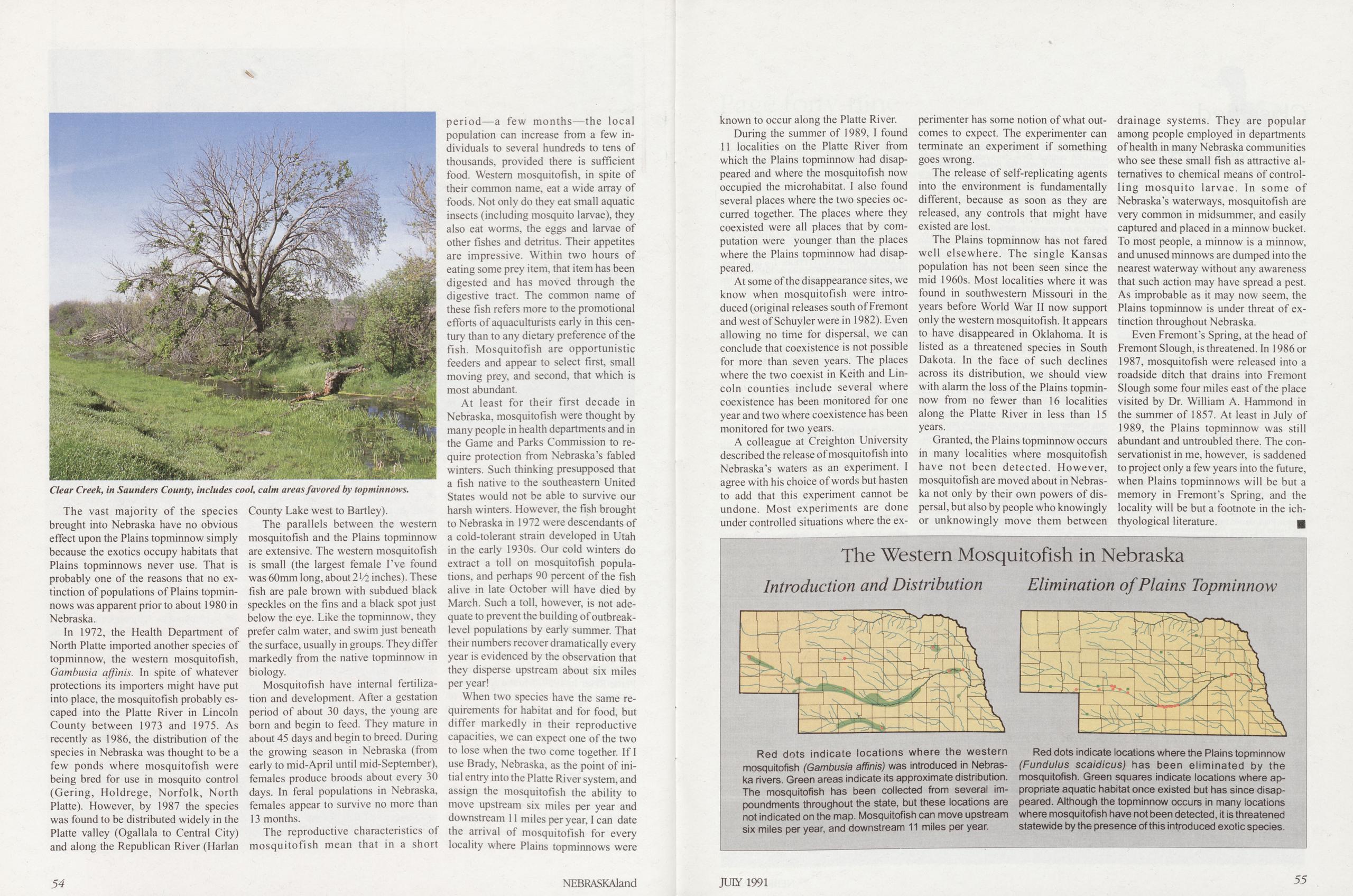
The vast majority of the species brought into Nebraska have no obvious effect upon the Plains topminnow simply because the exotics occupy habitats that Plains topminnows never use. That is probably one of the reasons that no extinction of populations of Plains topminnows was apparent prior to about 1980 in Nebraska.
In 1972, the Health Department of North Platte imported another species of topminnow, the western mosquitofish, Gambusia affinis. In spite of whatever protections its importers might have put into place, the mosquitofish probably escaped into the Platte River in Lincoln County between 1973 and 1975. As recently as 1986, the distribution of the species in Nebraska was thought to be a few ponds where mosquitofish were being bred for use in mosquito control (Gering, Holdrege, Norfolk, North Platte). However, by 1987 the species was found to be distributed widely in the Platte valley (Ogallala to Central City) and along the Republican River (Harlan County Lake west to Bartley).
The parallels between the western mosquitofish and the Plains topminnow are extensive. The western mosquitofish is small (the largest female I’ve found was 60mm long, about 2 Vi inches). These fish are pale brown with subdued black speckles on the fins and a black spot just below the eye. Like the topminnow, they prefer calm water, and swim just beneath the surface, usually in groups. They differ markedly from the native topminnow in biology.
Mosquitofish have internal fertilization and development. After a gestation period of about 30 days, the young are bom and begin to feed. They mature in about 45 days and begin to breed. During the growing season in Nebraska (from early to mid-April until mid-September), females produce broods about every 30 days. In feral populations in Nebraska, females appear to survive no more than 13 months.
The reproductive characteristics of mosquitofish mean that in a short period—a few months—the local population can increase from a few individuals to several hundreds to tens of thousands, provided there is sufficient food. Western mosquitofish, in spite of their common name, eat a wide array of foods. Not only do they eat small aquatic insects (including mosquito larvae), they also eat worms, the eggs and larvae of other fishes and detritus. Their appetites are impressive. Within two hours of eating some prey item, that item has been digested and has moved through the digestive tract. The common name of these fish refers more to the promotional efforts of aquaculturists early in this century than to any dietary preference of the fish. Mosquitofish are opportunistic feeders and appear to select first, small moving prey, and second, that which is most abundant.
At least for their first decade in Nebraska, mosquitofish were thought by many people in health departments and in the Game and Parks Commission to require protection from Nebraska’s fabled winters. Such thinking presupposed that a fish native to the southeastern United States would not be able to survive our harsh winters. However, the fish brought to Nebraska in 1972 were descendants of a cold-tolerant strain developed in Utah in the early 1930s. Our cold winters do extract a toll on mosquitofish populations, and perhaps 90 percent of the fish alive in late October will have died by March. Such a toll, however, is not adequate to prevent the building of outbreak- level populations by early summer. That their numbers recover dramatically every year is evidenced by the observation that they disperse upstream about six miles per year!
When two species have the same requirements for habitat and for food, but differ markedly in their reproductive capacities, we can expect one of the two to lose when the two come together. If I use Brady, Nebraska, as the point of initial entry into the Platte River system, and assign the mosquitofish the ability to move upstream six miles per year and downstream 11 miles per year, I can date the arrival of mosquitofish for every locality where Plains topminnows were known to occur along the Platte River.
During the summer of 1989, I found 11 localities on the Platte River from which the Plains topminnow had disappeared and where the mosquitofish now occupied the microhabitat. I also found several places where the two species occurred together. The places where they coexisted were all places that by computation were younger than the places where the Plains topminnow had disappeared.
At some of the disappearance sites, we know when mosquitofish were introduced (original releases south of Fremont and west of Schuyler were in 1982). Even allowing no time for dispersal, we can conclude that coexistence is not possible for more than seven years. The places where the two coexist in Keith and Lincoln counties include several where coexistence has been monitored for one year and two where coexistence has been monitored for two years.
A colleague at Creighton University described the release of mosquitofish into Nebraska’s waters as an experiment. I agree with his choice of words but hasten to add that this experiment cannot be undone. Most experiments are done under controlled situations where the experimenter has some notion of what out- comes to expect. The experimenter can terminate an experiment if something goes wrong.
The release of self-replicating agents into the environment is fundamentally different, because as soon as they are released, any controls that might have existed are lost.
The Plains topminnow has not fared well elsewhere. The single Kansas population has not been seen since the mid 1960s. Most localities where it was found in southwestern Missouri in the years before World War II now support only the western mosquitofish. It appears to have disappeared in Oklahoma. It is listed as a threatened species in South Dakota. In the face of such declines across its distribution, we should view with alarm the loss of the Plains topminnow from no fewer than 16 localities along the Platte River in less than 15 years.
Granted, the Plains topminnow occurs in many localities where mosquitofish have not been detected. However, mosquitofish are moved about in Nebraska not only by their own powers of dispersal, but also by people who knowingly or unknowingly move them between drainage systems. They are popular among people employed in departments of health in many Nebraska communities who see these small fish as attractive alternatives to chemical means of controlling mosquito larvae. In some of Nebraska’s waterways, mosquitofish are very common in midsummer, and easily captured and placed in a minnow bucket. To most people, a minnow is a minnow, and unused minnows are dumped into the nearest waterway without any awareness that such action may have spread a pest. As improbable as it may now seem, the Plains topminnow is under threat of extinction throughout Nebraska.
Even Fremont’s Spring, at the head of Fremont Slough, is threatened. In 1986 or 1987, mosquitofish were released into a roadside ditch that drains into Fremont Slough some four miles east of the place visited by Dr. William A. Hammond in the summer of 1857. At least in July of 1989, the Plains topminnow was still abundant and untroubled there. The conservationist in me, however, is saddened to project only a few years into the future, when Plains topminnows will be but a memory in Fremont’s Spring, and the locality will be but a footnote in the ichthyological literature.
The Western Mosquitofish in Nebraska
Introduction and Distribution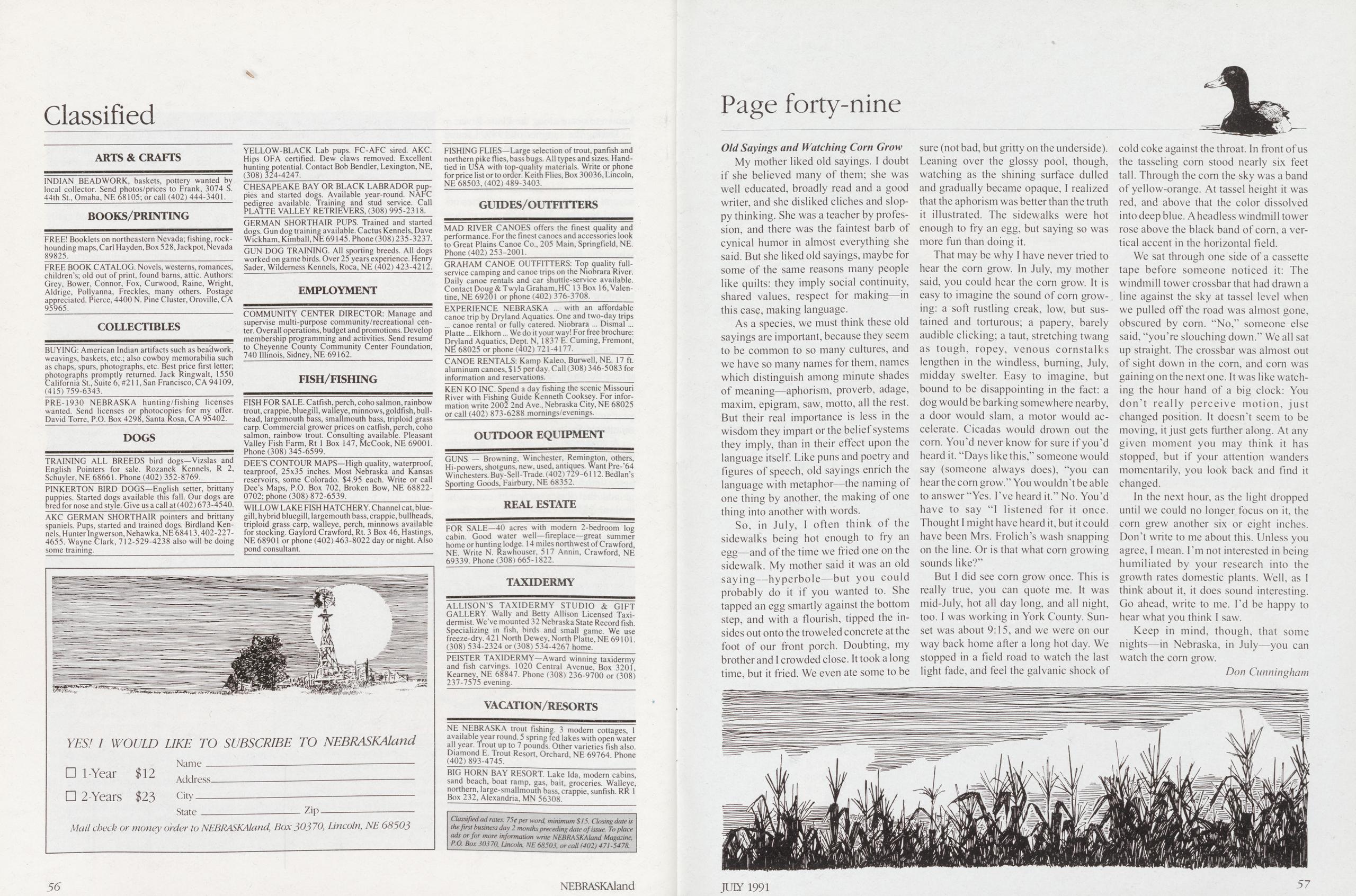
INDIAN BEADWORK, baskets, pottery wanted by local collector. Send photos/prices to Frank, 3074 S. 44th St., Omaha, NE 68105; or call (402) 444-3401,
BOOKS/PRINTINGFREE! Booklets on northeastern Nevada; fishing, rock- hounding maps, Carl Hayden, Box 528, Jackpot, Nevada 89825.
FREE BOOK CATALOG. Novels, westerns, romances, children’s; old out of print, found barns, attic. Authors: Grey, Bower, Connor, Fox, Curwood, Raine, Wright, Aldrige, Pollyanna, Freckles, many others. Postage appreciated. Pierce, 4400 N. Pine Cluster, Oroville, CA 95965.
COLLECTIBLESBUYING: American Indian artifacts such as beadwork, weavings, baskets, etc.; also cowboy memorabilia such as chaps, spurs, photographs, etc. Best price first letter; photographs promptly returned. Jack Ringwait, 1550 California St., Suite 6, #211, San Francisco, CA 94109, (415)759-6343.
PRE-1930 NEBRASKA hunting/fishing licenses wanted. Send licenses or photocopies for my offer. David Torre, P.O. Box 4298, Santa Rosa, CA 95402.
DOGSTRAINING ALL BREEDS bird dogs—Vizslas and English Pointers for sale. Rozanek Kennels, R 2, Schuyler, NE 68661. Phone (402) 352-8769.
PINKERTON BIRD DOGS—English setter, brittany puppies. Started dogs available this fall. Our dogs are bred for nose and style. Give us a call at (402) 673-4540.
AKC GERMAN SHORTHAIR pointers and brittany spaniels. Pups, started and trained dogs. Birdland Ken- nels, Hunter Ingwerson, Nehawka, NE 68413,402-227- 4655. Wayne Clark, 712-529-4238 also will be doing some training.
YELLOW-BLACK Lab pups. FC-AFC sired. AKC. Hips OFA certified. Dew claws removed. Excellent hunting potential. Contact Bob Bendler, Lexington, NE, (308) 324-4247.
CHESAPEAKE BAY OR BLACK LABRADOR pup- pies and started dogs. Available year-round. NAFC pedigree available. Training and stud service. Call PLATTE VALLEY RETRIEVERS, (308) 995-2318.
GERMAN SHORTHAIR PUPS. Trained and started dogs. Gun dog training available. Cactus Kennels, Dave Wickham, Kimball, NE 69145. Phone (308) 235-3237.
GUN DOG TRAINING. All sporting breeds. All dogs worked on game birds. Over 25 years experience. Henry Sader, Wilderness Kennels, Roca, NE (402) 423-4212.
EMPLOYMENTCOMMUNITY CENTER DIRECTOR: Manage and supervise multi-purpose community/recreational cen- ter. Overall operations, budget and promotions. Develop membership programming and activities. Send resumd to Cheyenne County Community Center Foundation, 740 Illinois, Sidney, NE 69162.
FISH/FISHINGFISH FOR SALE. Catfish, perch, coho salmon, rainbow trout, crappie, bluegill, walleye, minnows, goldfish, bull- head, largemouth bass, smallmouth bass, triploid grass carp. Commercial grower prices on catfish, perch, coho salmon, rainbow trout. Consulting available. Pleasant Valley Fish Farm, Rt 1 Box 147, McCook, NE 69001. Phone (308) 345-6599.
DEE’S CONTOUR MAPS—High quality, waterproof, tearproof, 25x35 inches. Most Nebraska and Kansas reservoirs, some Colorado. $4.95 each. Write or call Dee’s Maps, P.O. Box 702, Broken Bow, NE 68822- 0702; phone (308) 872-6539.
WILLOW LAKE FISH HATCHERY. Channel cat, blue- gill, hybrid bluegill, largemouth bass, crappie, bullheads, triploid grass carp, walleye, perch, minnows available for stocking. Gaylord Crawford, Rt. 3 Box 46, Hastings, NE 68901 or phone (402) 463-8022 day or night. Also pond consultant.
FISHING FLIES—Large selection of trout, panfish and northern pike flies, bass bugs. All types and sizes. Hand- tied in USA with top-quality materials. Write or phone for price list or to order. Keith Flies, Box 30036, Lincoln, NE 68503,(402)489-3403.
GUIDES/OUTFITTERSMAD RIVER CANOES offers the finest quality and performance. For the finest canoes and accessories look to Great Plains Canoe Co., 205 Main, Springfield, NE. Phone(402)253-2001.
GRAHAM CANOE OUTFITTERS: Top quality full- service camping and canoe trips on the Niobrara River. Daily canoe rentals and car shuttie-service available. Contact Doug & Twyla Graham, HC 13 Box 16, Valen- tine, NE 69201 or phone (402) 376-3708.
EXPERIENCE NEBRASKA ... with an affordable canoe trip by Dryland Aquatics. One and two-day trips ... canoe rental or fully catered. Niobrara ... Dismal ... Platte... Elkhorn... We do it your way! For free brochure: Dryland Aquatics, Dept. N, 1837 E. Cuming, Fremont, NE 68025 or phone (402) 721-4177.
CANOE RENTALS: Kamp Kaleo, Burwell, NE. 17 ft. aluminum canoes, $ 15 per day. Call (308) 346-5083 for information and reservations.
KEN KO INC. Spend a day fishing the scenic Missouri River with Fishing Guide Kenneth Cooksey. For infor- mation write 2002 2nd Ave., Nebraska City, NE 68025 or call (402) 873-6288 momings/evenings.
OUTDOOR EQUIPMENTGUNS — Browning, Winchester, Remington, others, Hi-powers, shotguns, new, used, antiques. Want Pre-'64 Winchesters. Buy-Sell-Trade. (402) 729-6112. Bedlan’s Sporting Goods, Fairbury, NE 68352.
REAL ESTATEFOR SALE—40 acres with modern 2-bedroom log cabin. Good water well—fireplace—great summer home or hunting lodge. 14 miles northwest of Crawford, NE Write N. Rawhouser, 517 Annin, Crawford, NE 69339. Phone (308) 665-1822.
TAXIDERMYALLISON’S TAXIDERMY STUDIO & GIFT GALLERY Wally and Betty Allison Licensed Taxi- dermist. We've mounted 32 Nebraska State Record fish. Specializing in fish, birds and small game. We use freeze-dry. 421 North Dewey, North Platte, NE 69101. (308) 534-2324 or (308) 534-4267 home.___ PEISTER TAXIDERMY—Award winning taxidermy and fish carvings. 1020 Central Avenue, Box 3201, Kearney, NE 68847. Phone (308) 236-9700 or (308) 237-7575 evening.
VACATION/RESORTSNE NEBRASKA trout fishing. 3 modern cottages, 1 available year round. 5 spring fed lakes with open water all year. Trout up to 7 pounds. Other varieties fish also. Diamond E. Trout Resort, Orchard, NE 69764. Phone (402) 893-4745.
BIG HORN BAY RESORT. Lake Ida, modern cabins, sand beach, boat ramp, gas, bait, groceries. Walleye, northern, large-smallmouth bass, crappie, sunfish. RR 1 Box 232, Alexandria, MN 56308.
Classified ad rates: 75c per word, minimum $15. Closing date is the first business day 2 months preceding date of issue. To place ads or for more information write NEBRASKAland Magazine, P.O. Box 30370, Lincoln, NE 68503, or call (402) 471-5478.My mother liked old sayings. I doubt if she believed many of them; she was well educated, broadly read and a good writer, and she disliked cliches and sloppy thinking. She was a teacher by profession, and there was the faintest barb of cynical humor in almost everything she said. But she liked old sayings, maybe for some of the same reasons many people like quilts: they imply social continuity, shared values, respect for making—in this case, making language.
As a species, we must think these old sayings are important, because they seem to be common to so many cultures, and we have so many names for them, names which distinguish among minute shades of meaning—aphorism, proverb, adage, maxim, epigram, saw, motto, all the rest. But their real importance is less in the wisdom they impart or the belief systems they imply, than in their effect upon the language itself. Like puns and poetry and figures of speech, old sayings enrich the language with metaphor—the naming of one thing by another, the making of one thing into another with words.
So, in July, I often think of the sidewalks being hot enough to fry an egg—and of the time we fried one on the sidewalk. My mother said it was an old saying—hyperbole—but you could probably do it if you wanted to. She tapped an egg smartly against the bottom step, and with a flourish, tipped the insides out onto the troweled concrete at the foot of our front porch. Doubting, my brother and I crowded close. It took a long time, but it fried. We even ate some to be sure (not bad, but gritty on the underside). Leaning over the glossy pool, though, watching as the shining surface dulled and gradually became opaque, I realized that the aphorism was better than the truth it illustrated. The sidewalks were hot enough to fry an egg, but saying so was more fun than doing it.
That may be why I have never tried to hear the corn grow. In July, my mother said, you could hear the com grow. It is easy to imagine the sound of com growing: a soft rustling creak, low, but sustained and torturous; a papery, barely audible clicking; a taut, stretching twang as tough, ropey, venous cornstalks lengthen in the windless, burning, July, midday swelter. Easy to imagine, but bound to be disappointing in the fact: a dog would be barking somewhere nearby, a door would slam, a motor would accelerate. Cicadas would drown out the corn. You'd never know for sure if you’d heard it. “Days like this,” someone would say (someone always does), “you can hear the com grow.” You wouldn’t be able to answer “Yes. I’ve heard it.” No. You’d have to say “I listened for it once.
Thought I might have heard it, but it could have been Mrs. Frolich’s wash snapping on the line. Or is that what com growing sounds like?”
But I did see corn grow once. This is really true, you can quote me. It was mid-July, hot all day long, and all night, too. I was working in York County. Sunset was about 9:15, and we were on our way back home after a long hot day. We stopped in a field road to watch the last light fade, and feel the galvanic shock of cold coke against the throat. In front of us the tasseling com stood nearly six feet tall. Through the com the sky was a band of yellow-orange. At tassel height it was red, and above that the color dissolved into deep blue. A headless windmill tower rose above the black band of corn, a vertical accent in the horizontal field.
We sat through one side of a cassette tape before someone noticed it: The windmill tower crossbar that had drawn a line against the sky at tassel level when we pulled off the road was almost gone, obscured by com. “No,” someone else said, “you’re slouching down.” We all sat up straight. The crossbar was almost out of sight down in the corn, and corn was gaining on the next one. It was like watching the hour hand of a big clock: You don’t really perceive motion, just changed position. It doesn’t seem to be moving, it just gets further along. At any given moment you may think it has stopped, but if your attention wanders momentarily, you look back and find it changed.
In the next hour, as the light dropped until we could no longer focus on it, the corn grew another six or eight inches. Don't write to me about this. Unless you agree, I mean. I’m not interested in being humiliated by your research into the growth rates domestic plants. Well, as I think about it, it does sound interesting. Go ahead, write to me. I'd be happy to hear what you think I saw.
Keep in mind, though, that some nights—in Nebraska, in July—you can watch the corn grow.
Don Cunningham 56 NEBRASKAland JUIY 1991 57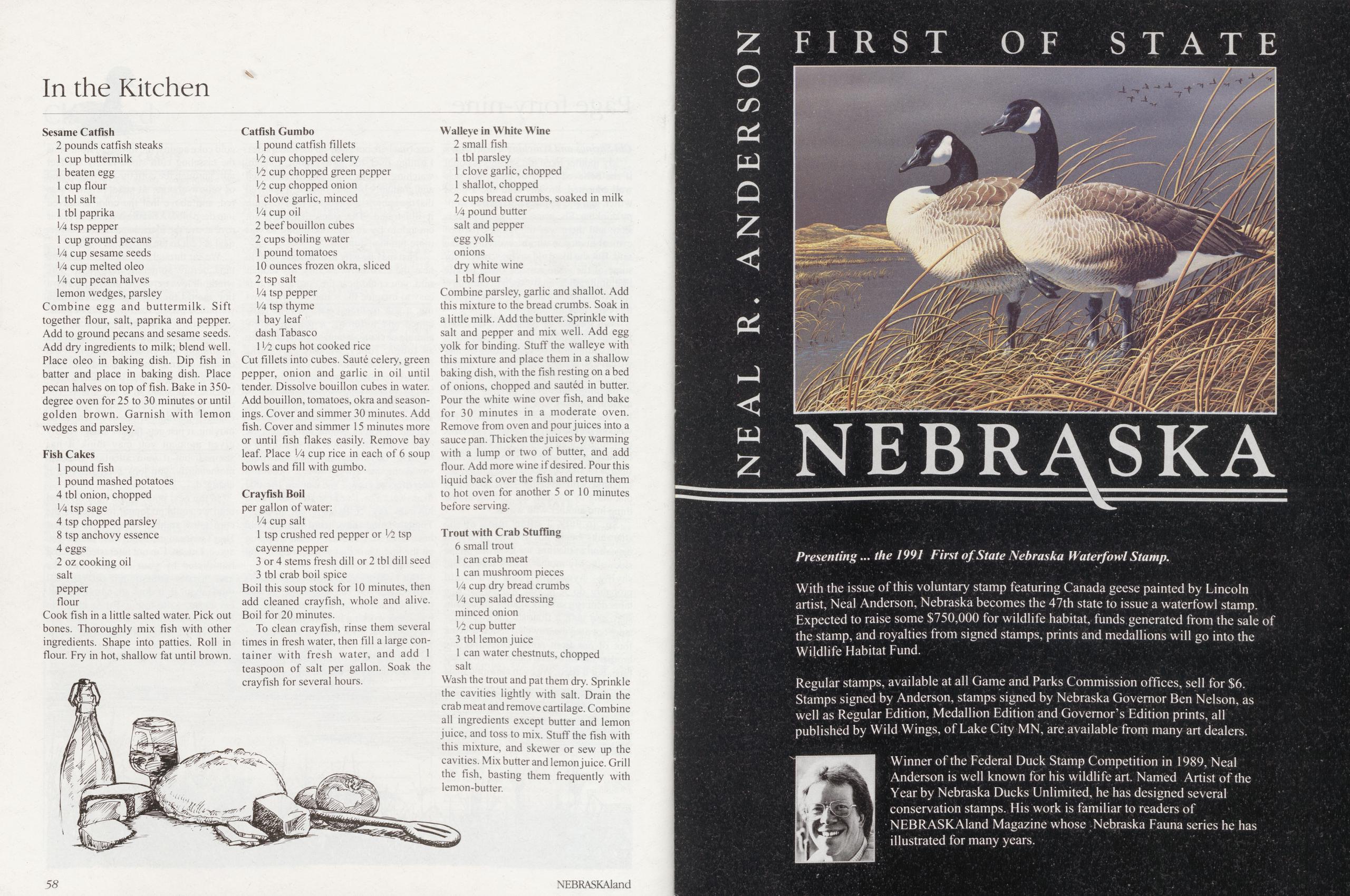
2 pounds catfish steaks
1 cup buttermilk
1 beaten egg
1 cup flour
1 tbl salt
1 tbl paprika
1/4 tsp pepper
1 cup ground pecans
1/4 cup sesame seeds
14 cup melted oleo
1/4 cup pecan halves
lemon wedges, parsley
Combine egg and buttermilk. Sift together flour, salt, paprika and pepper. Add to ground pecans and sesame seeds. Add dry ingredients to milk; blend well. Place oleo in baking dish. Dip fish in batter and place in baking dish. Place pecan halves on top of fish. Bake in 350- degree oven for 25 to 30 minutes or until golden brown. Garnish with lemon wedges and parsley.
Fish Cakes1 pound fish
1 pound mashed potatoes
4 tbl onion, chopped
1/4 tsp sage
4 tsp chopped parsley
8 tsp anchovy essence
4 eggs
2 oz cooking oil
salt
pepper
flour
Cook fish in a little salted water. Pick out bones. Thoroughly mix fish with other ingredients. Shape into patties. Roll in flour. Fry in hot, shallow fat until brown.
Catfish Gumbo1 pound catfish fillets
1/2 cup chopped celery
1/2 cup chopped green pepper
1/2 cup chopped onion
1 clove garlic, minced
1/4 cup oil
2 beef bouillon cubes
2 cups boiling water
1 pound tomatoes
10 ounces frozen okra, sliced
2 tsp salt
1/4 tsp pepper
1/4 tsp thyme
1 bay leaf
dash Tabasco
11/2 cups hot cooked rice
Cut fillets into cubes. Saute celery, green pepper, onion and garlic in oil until tender. Dissolve bouillon cubes in water. Add bouillon, tomatoes, okra and season- ings. Cover and simmer 30 minutes. Add fish. Cover and simmer 15 minutes more or until fish flakes easily. Remove bay leaf. Place 1/4 cup rice in each of 6 soup bowls and fill with gumbo.
Crayfish Boilper gallon of water:
1/4 cup salt
1 tsp crushed red pepper or 1/2 tsp
cayenne pepper
3 or 4 stems fresh dill or 2 tbl dill seed
3 tbl crab boil spice
Boil this soup stock for 10 minutes, then add cleaned crayfish, whole and alive. Boil for 20 minutes.
To clean crayfish, rinse them several times in fresh water, then fill a large con- tainer with fresh water, and add 1 teaspoon of salt per gallon. Soak the crayfish for several hours.
Walleye in White Wine2 small fish
1 tbl parsley
1 clove garlic, chopped
1 shallot, chopped
2 cups bread crumbs, soaked in milk
1/4 pound butter
salt and pepper
egg yolk
onions
dry white wine
1 tbl flour
Combine parsley, garlic and shallot. Add this mixture to the bread crumbs. Soak in a little milk. Add the butter. Sprinkle with salt and pepper and mix well. Add egg yolk for binding. Stuff the walleye with this mixture and place them in a shallow baking dish, with the fish resting on a bed of onions, chopped and sauted in butter. Pour the white wine over fish, and bake for 30 minutes in a moderate oven. Remove from oven and pour juices into a sauce pan. Thicken the juices by warming with a lump or two of butter, and add flour. Add more wine if desired. Pour this liquid back over the fish and return them to hot oven for another 5 or 10 minutes before serving.
Trout with Crab Stuffing6 small trout
1 can crab meat
1 can mushroom pieces
1/4 cup dry bread crumbs
1/4 cup salad dressing
minced onion
1/i cup butter
3 tbl lemon juice
1 can water chestnuts, chopped
salt
Wash the trout and pat them dry. Sprinkle the cavities lightly with salt. Drain the crab meat and remove cartilage. Combine all ingredients except butter and lemon juice, and toss to mix. Stuff the fish with this mixture, and skewer or sew up the cavities. Mix butter and lemon juice. Grill the fish, basting them frequently with lemon-butter.
NEBRASKA
Presenting... the 1991 First of. State Nebraska Waterfowl Stamp.With the issue of this voluntary stamp featuring Canada geese painted by Lincoln artist, Neal Anderson, Nebraska becomes the 47th state to issue a waterfowl stamp. Expected to raise some $750,000 for wildlife habitat, funds generated from the sale of the stamp, and royalties from signed stamps, prints and medallions will go into the Wildlife Habitat Fund.
Regular stamps, available at all Game and Parks Commission offices, sell for $6. Stamps signed by Anderson, stamps signed by Nebraska Governor Ben Nelson, as well as Regular Edition, Medallion Edition and Governor’s Edition prints, all published by Wild Wings, of Lake City MN, are available from many art dealers. Winner of the Federal Duck Stamp Competition in 1989, Neal Anderson is well known for his wildlife art. Named Artist of the Year by Nebraska Ducks Unlimited, he has designed several conservation stamps. His work is familiar to readers of NEBRASKAland Magazine whose Nebraska Fauna series he has illustrated for many years.
58 NEBRASKAland
Position: 252 (32 views)