Volume 57, Issue 4, 1979
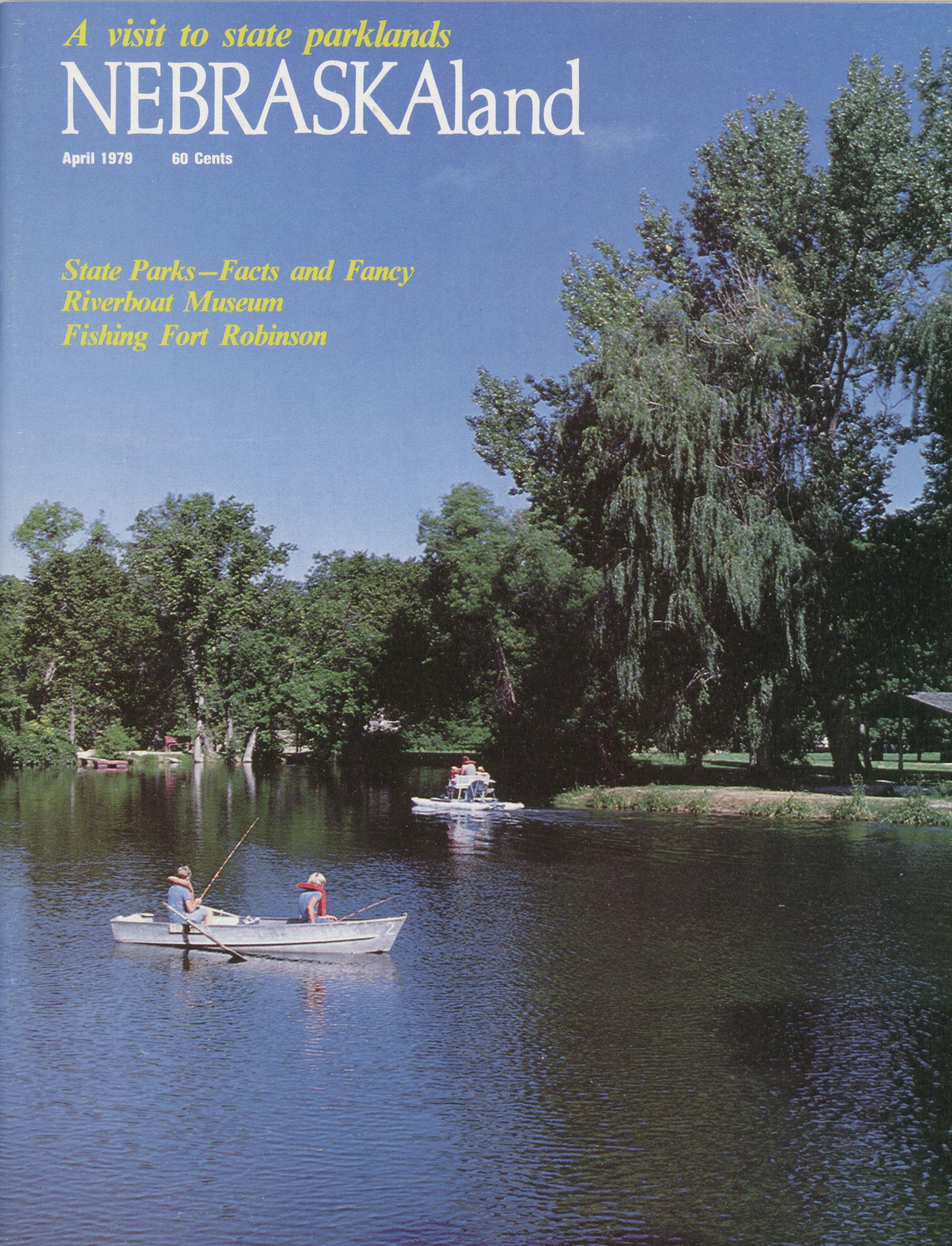
NEBRASKAland
A visit to state park lands
State Parks - Facts and Fancy
Riverboat Museum
Fishing Fort Robinson
April 1979 60 Cents
NEBRASKAland
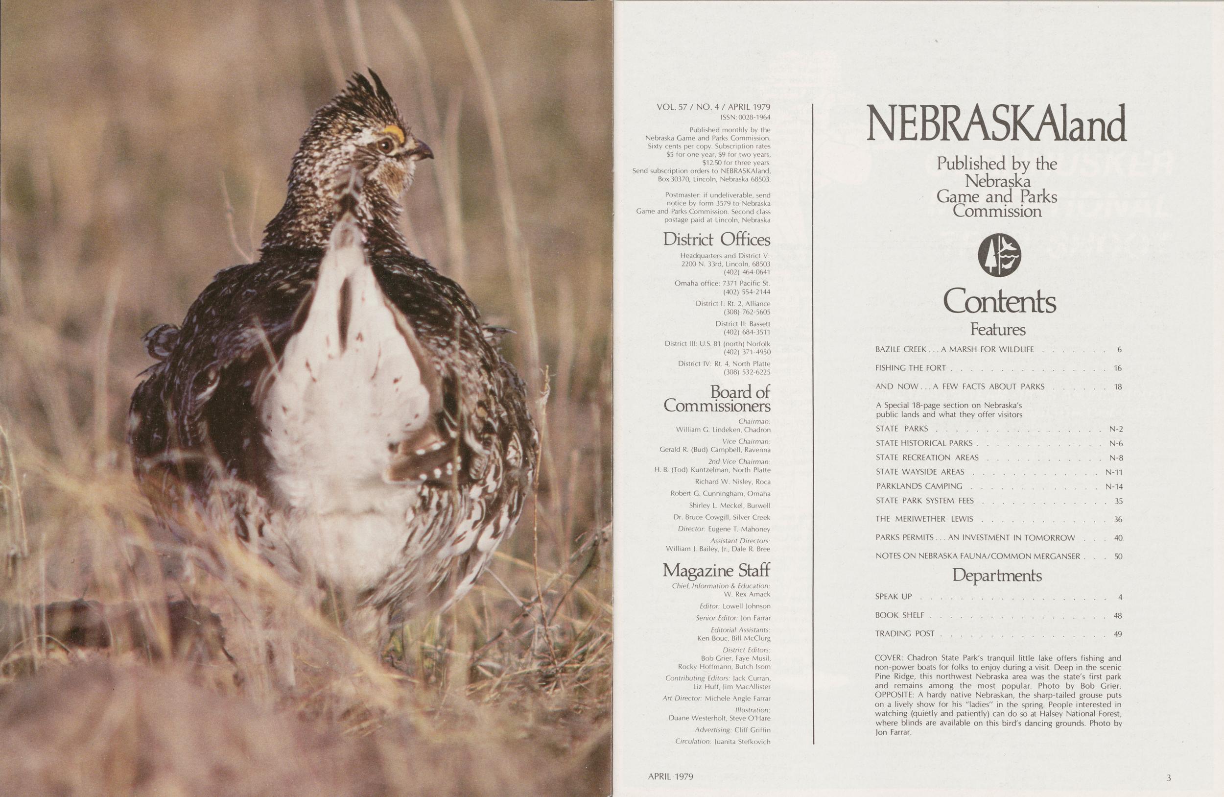
Published by the Nebraska Game and Parks Commission Contents Features BAZILE CREEK...A MARSH FOR WILDLIFE 6 FISHING THE FORT 16 AND NOW ...A FEW FACTS ABOUT PARKS 18 A Special 18-page section on Nebraska's public lands and what they offer visitors STATE PARKS N-2 STATE HISTORICAL PARKS N-6 STATE RECREATION AREAS N-8 STATE WAYSIDE AREAS N-11 PARKLANDS CAMPING N-14 STATE PARK SYSTEM FEES 35 THE MERIWETHER LEWIS 36 PARKS PERMITS ... AN INVESTMENT IN TOMORROW 40 NOTES ON NEBRASKA FAUNA/COMMON MERGANSER 50 Departments SPEAK UP 4 BOOK SHELF 48 TRADING POST 49COVER: Chadron State Park's tranquil little lake offers fishing and non-power boats for folks to enjoy during a visit. Deep in the scenic Pine Ridge, this northwest Nebraska area was the state's first park and remains among the most popular. Photo by Bob Grier. OPPOSITE: A hardy native Nebraskan, the sharp-tailed grouse puts on a lively show for his "ladies" in the spring. People interested in watching (quietiy and patiently) can do so at Halsey National Forest, where blinds are available on this bird's dancing grounds. Photo by Jon Farrar.
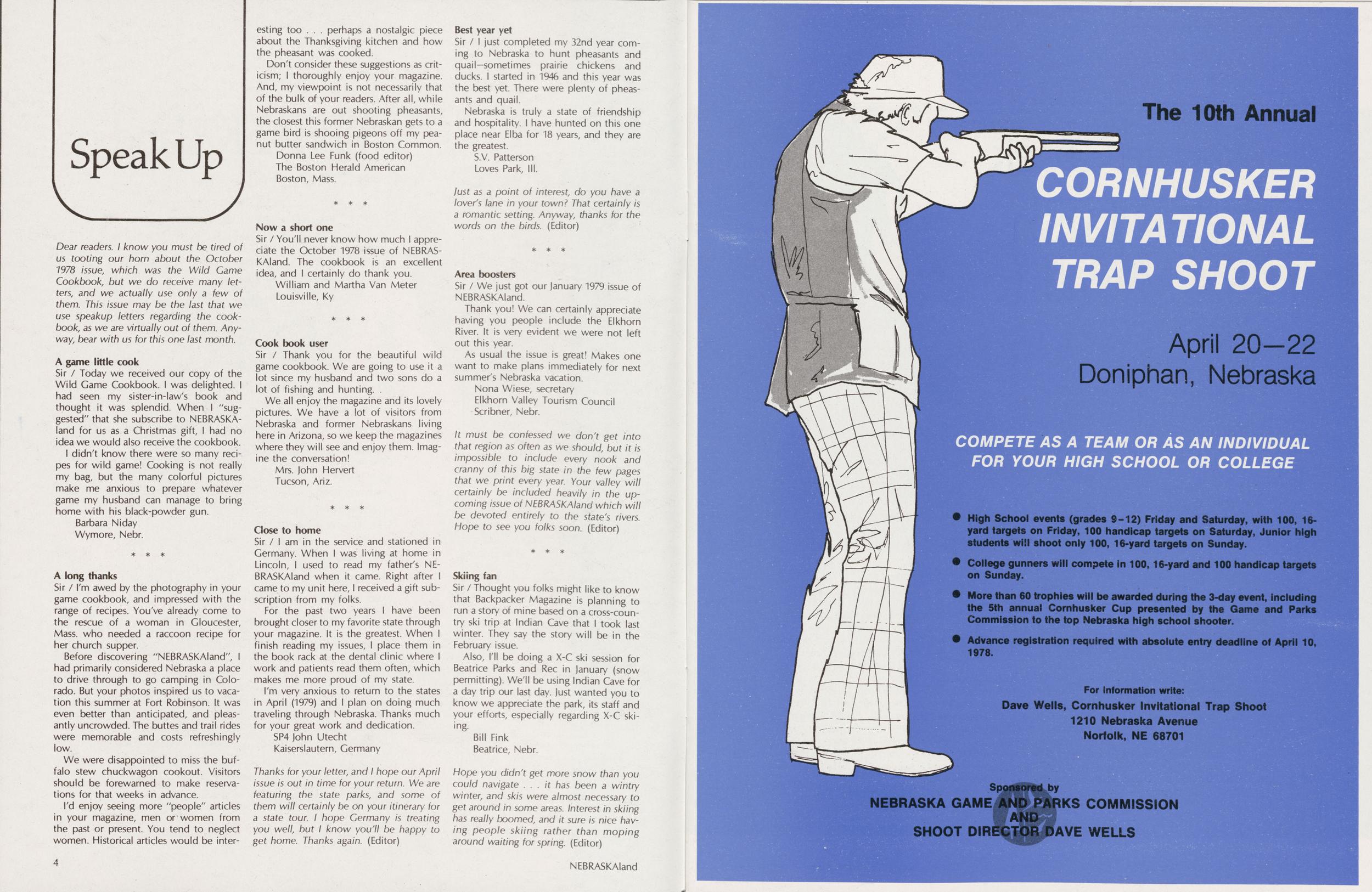
Speak Up
Dear readers. I know you must be tired of us tooting our horn about the October 1978 issue, which was the Wild Game Cookbook, but we do receive many letters, and we actually use only a few of them. This issue may be the last that we use speakup letters regarding the cookbook, as we are virtually out of them. Anyway, bear with us for this one last month.
A game little cookSir / Today we received our copy of the Wild Game Cookbook. I was delighted. I had seen my sister-in-law's book and thought it was splendid. When I "suggested" that she subscribe to NEBRASKAland for us as a Christmas gift, I had no idea we would also receive the cookbook.
I didn't know there were so many recipes for wild game! Cooking is not really my bag, but the many colorful pictures make me anxious to prepare whatever game my husband can manage to bring home with his black-powder gun.
Barbara Niday Wymore, Nebr. A long thanksSir / I'm awed by the photography in your game cookbook, and impressed with the range of recipes. You've already come to the rescue of a woman in Gloucester, Mass. who needed a raccoon recipe for her church supper.
Before discovering "NEBRASKAland", I had primarily considered Nebraska a place to drive through to go camping in Colorado. But your photos inspired us to vacation this summer at Fort Robinson. It was even better than anticipated, and pleasantly uncrowded. The buttes and trail rides were memorable and costs refreshingly low.
We were disappointed to miss the buffalo stew chuckwagon cookout. Visitors should be forewarned to make reservations for that weeks in advance.
I'd enjoy seeing more "people" articles in your magazine, men or women from the past or present. You tend to neglect women. Historical articles would be interesting too... perhaps a nostalgic piece about the Thanksgiving kitchen and how the pheasant was cooked.
Don't consider these suggestions as criticism; I thoroughly enjoy your magazine. And, my viewpoint is not necessarily that of the bulk of your readers. After all, while Nebraskans are out shooting pheasants, the closest this former Nebraskan gets to a game bird is shooing pigeons off my peanut butter sandwich in Boston Common.
Donna Lee Funk (food editor) The Boston Herald American Boston, Mass. Now a short oneSir / You'll never know how much I appreciate the October 1978 issue of NEBRASKAland. The cookbook is an excellent idea, and I certainly do thank you.
William and Martha Van Meter Louisville, Ky Cook book userSir / Thank you for the beautiful wild game cookbook. We are going to use it a lot since my husband and two sons do a lot of fishing and hunting.
We all enjoy the magazine and its lovely pictures. We have a lot of visitors from Nebraska and former Nebraskans living here in Arizona, so we keep the magazines where they will see and enjoy them. Imagine the conversation!
Mrs. John Hervert Tucson, Ariz. Close to homeSir / I am in the service and stationed in Germany. When I was living at home in Lincoln, I used to read my father's NEBRASKAland when it came. Right after I came to my unit here, I received a gift subscription from my folks.
For the past two years I have been brought closer to my favorite state through your magazine. It is the greatest. When I finish reading my issues, I place them in the book rack at the dental clinic where work and patients read them often, which makes me more proud of my state.
I'm very anxious to return to the states in April (1979) and I plan on doing much traveling through Nebraska. Thanks much for your great work and dedication.
SP4 John Utecht Kaiserslautern, GermanyThanks for your letter, and I hope our April issue is out in time for your return. We are featuring the state parks, and some of them will certainly be on your itinerary for a state tour. I hope Germany is treating you well, but I know you'll be happy to get home. Thanks again. (Editor)
Best year yetSir / I just completed my 32nd year coming to Nebraska to hunt pheasants and quail—sometimes prairie chickens and ducks. I started in 1946 and this year was the best yet. There were plenty of pheasants and quail.
Nebraska is truly a state of friendship and hospitality. I have hunted on this one place near Elba for 18 years, and they are the greatest.
S.V. Patterson Loves Park, III.Just as a point of interest, do you have a lover's lane in your town? That certainly is a romantic setting. Anyway, thanks for the words on the birds. (Editor)
Area boostersSir / We just got our January 1979 issue of NEBRASKAIand.
Thank you! We can certainly appreciate having you people include the Elkhorn River. It is very evident we were not left out this year.
As usual the issue is great! Makes one want to make plans immediately for next summer's Nebraska vacation.
Nona Wiese, secretary Elkhorn Valley Tourism Council Scribner. Nebr.It must be confessed we don't get into that region as often as we should, but it is impossible to include every nook and cranny of this big state in the few pages that we print every year. Your valley will certainly be included heavily in the upcoming issue of NEBRASKAland which will be devoted entirely to the state's rivers. Hope to see you folks soon. (Editor)
Skiing fanSir / Thought you folks might like to know that Backpacker Magazine is planning to run a story of mine based on a cross-country ski trip at Indian Cave that I took last winter. They say the story will be in the February issue.
Also, I'll be doing a X-C ski session for Beatrice Parks and Rec in January (snow permitting). We'll be using Indian Cave for a day trip our last day. just wanted you to know we appreciate the park, its staff and your efforts, especially regarding X-C skiing.
Bill Fink Beatrice, Nebr.Hope you didn't get more snow than you could navigate . . . it has been a wintry winter, and skis were almost necessary to get around in some areas. Interest in skiing has really boomed, and it sure is nice having people skiing rather than moping around waiting for spring. (Editor)
Bazile Creek
A Marsh
Wildlife
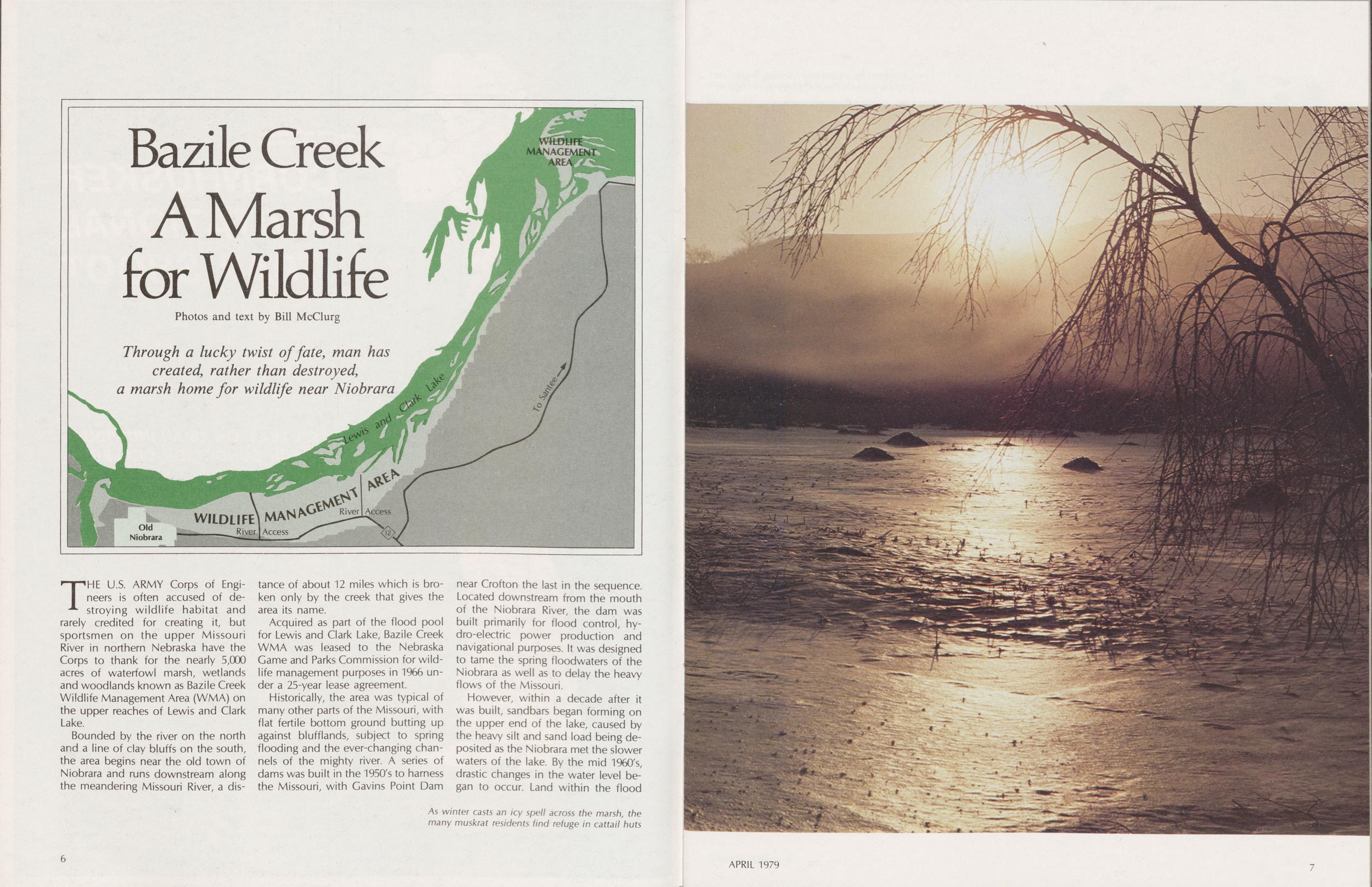
Through a lucky twist of fate, man has created, rather than destroyed, a marsh home for wildlife near Niobrara
WILDLIFE MANAGEMENT AREA
River Access
River Access
THE U.S. ARMY Corps of Engineers is often accused of destroying wildlife habitat and rarely credited for creating it, but sportsmen on the upper Missouri River in northern Nebraska have the Corps to thank for the nearly 5,000 acres of waterfowl marsh, wetlands and woodlands known as Bazile Creek Wildlife Management Area (WMA) on the upper reaches of Lewis and Clark Lake.
Bounded by the river on the north and a line of clay bluffs on the south, the area begins near the old town of Niobrara and runs downstream along the meandering Missouri River, a distance of about 12 miles which is broken only by the creek that gives the area its name.
Acquired as part of the flood pool for Lewis and Clark Lake, Bazile Creek WMA was leased to the Nebraska Game and Parks Commission for wildlife management purposes in 1966 under a 25-year lease agreement.
Historically, the area was typical of many other parts of the Missouri, with flat fertile bottom ground butting up against blufflands, subject to spring flooding and the ever-changing channels of the mighty river. A series of dams was built in the 1950's to harness the Missouri, with Gavins Point Dam near Crofton the last in the sequence. Located downstream from the mouth of the Niobrara River, the dam was built primarily for flood control, hydro-electric power production and navigational purposes. It was designed to tame the spring floodwaters of the Niobrara as well as to delay the heavy flows of the Missouri.
As winter casts an icy spell across the marsh, the many muskrat residents find refuge in cattail huts
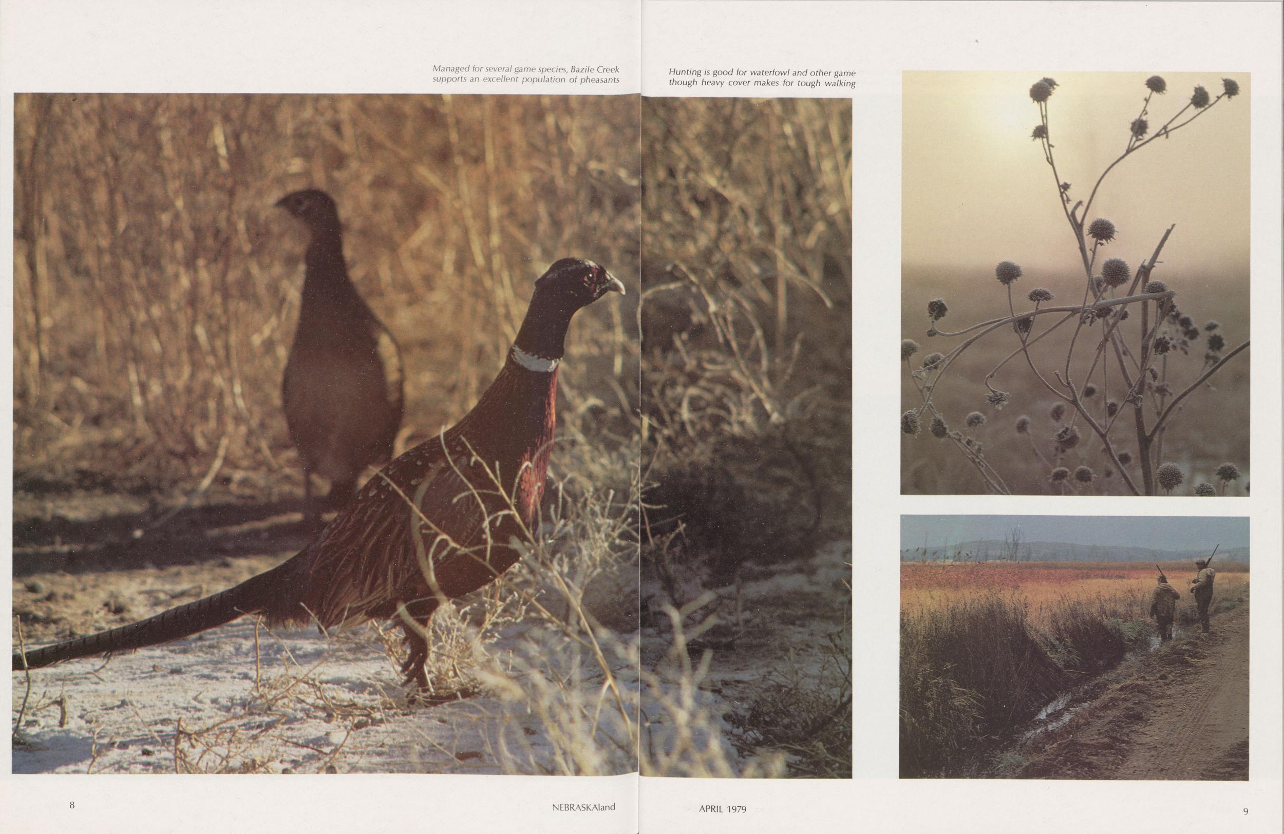
Managed for several game species, Bazile Creek supports an excellent population of pheasants
Hunting is good for waterfowl and other game though heavy cover makes for tough walking
 pool, which had been leased for farm
ground, developed into marsh while
existing marsh became deep water. In
a period of about 15 years, the total
marsh area increased from a few hundred acres to over 1,500.
pool, which had been leased for farm
ground, developed into marsh while
existing marsh became deep water. In
a period of about 15 years, the total
marsh area increased from a few hundred acres to over 1,500.On the surface, this would appear to be great news for duck hunters. However, a solid mass of cattails covers nearly all of the shallow portions of the marsh, making these areas of limited value to migrating waterfowl. Some fairly large open-water areas provide a fair amount of waterfowl habitat, but they constitute only a small portion of the marsh.
Increasing water levels have also taken their toll on some of the timbered areas at Bazile Creek WMA. Several tracts of mature cottonwoods have died out as a result of flooding, while others have become established in other areas. The single largest tract of timber on the area covers an estimated 200 acres, and lies within a few hundred yards of Bazile Creek. Elsewhere, a narrow band of timber follows the area boundary along the line of bluffs downstream from the mouth of Bazile Creek.
The remainder of Bazile Creek WMA consists of the larger open-water areas of the marsh and river, plus several small food and cover plots of corn, oats and sweet clover and adjacent large patches of annual vegetation.
IT IS SELDOM very crowded at Bazile Creek Wildlife Management Area. Managed as a public hunting and fishing area, the few improvements are limited to access roads and a boat ramp, although camping facilities are only a few miles away at Niobrara State Park.
Spring and summertime visitors come to fish, seek out bullfrogs or view the many creatures that live in the marsh and adjacent woodlands. Here, patient herons stalk the open water, hunting minnows and frogs, while coots and grebes paddle through the openings in the cattails. Redwings establish territories in the emergent vegetation, nest, and raise their young. Carp spawn in the shallows, providing forage for the walleye, sauger and catfish in the adjacent river and lake.
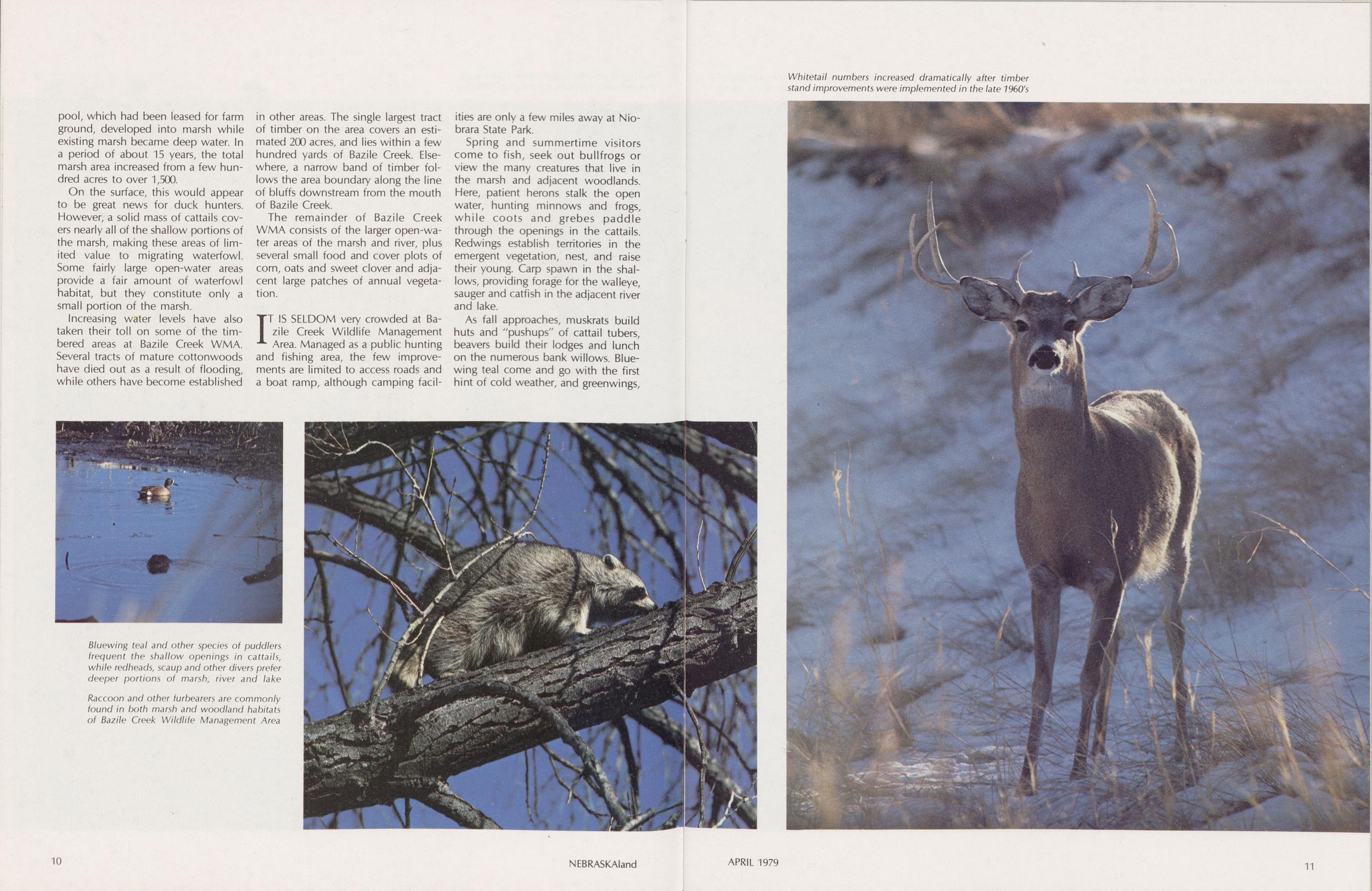
Bluewing teal and other species of puddlers frequent the shallow openings in cattails, while redheads, scaup and other divers prefer deeper portions of marsh, river and lake
Raccoon and other furbearers are commonly found in both marsh and woodland habitats of Bazile Creek Wildlife Management Area
Whitetail numbers increased dramatically after timber stand improvements were implemented in the late 1960's
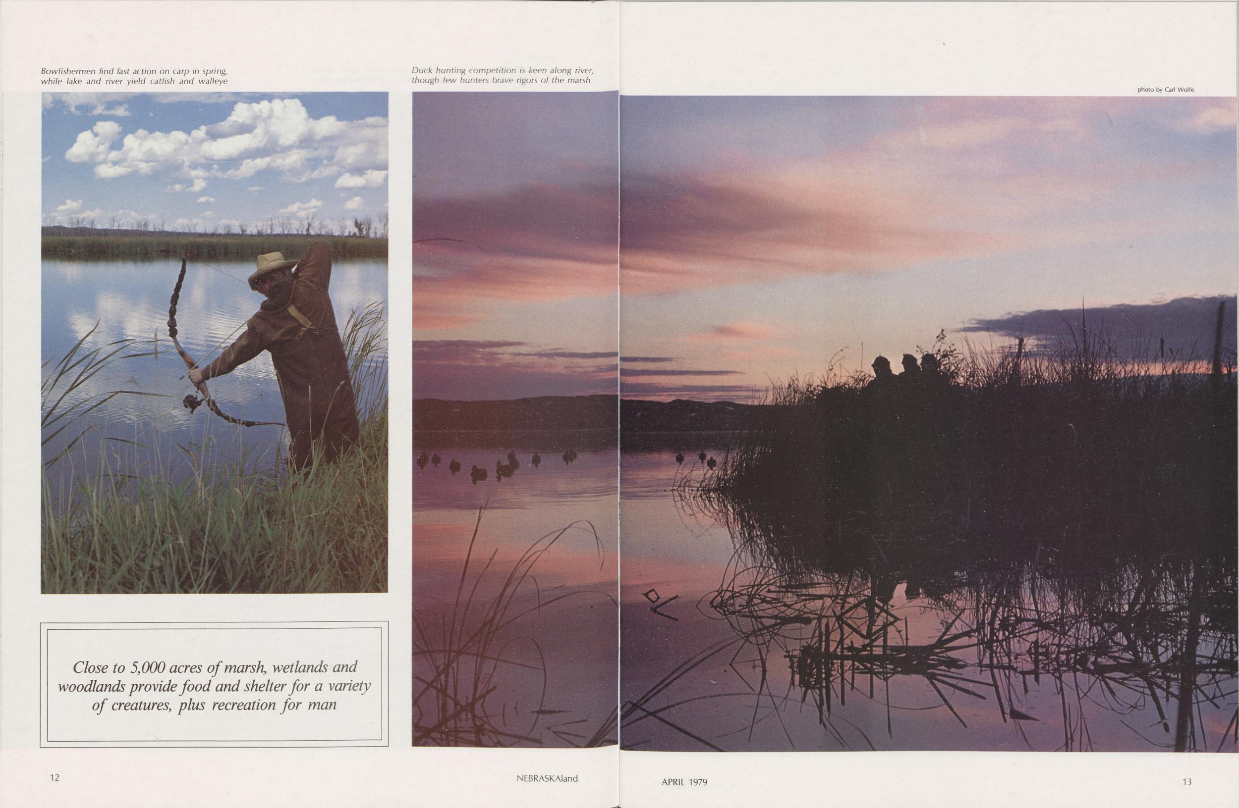
Bowfishermen find fast action on carp in spring, while lake and river yield catfish and walleye
Duck hunting competition is keen along river, though few hunters brave rigors of the marsh
photo by Carl Wolfe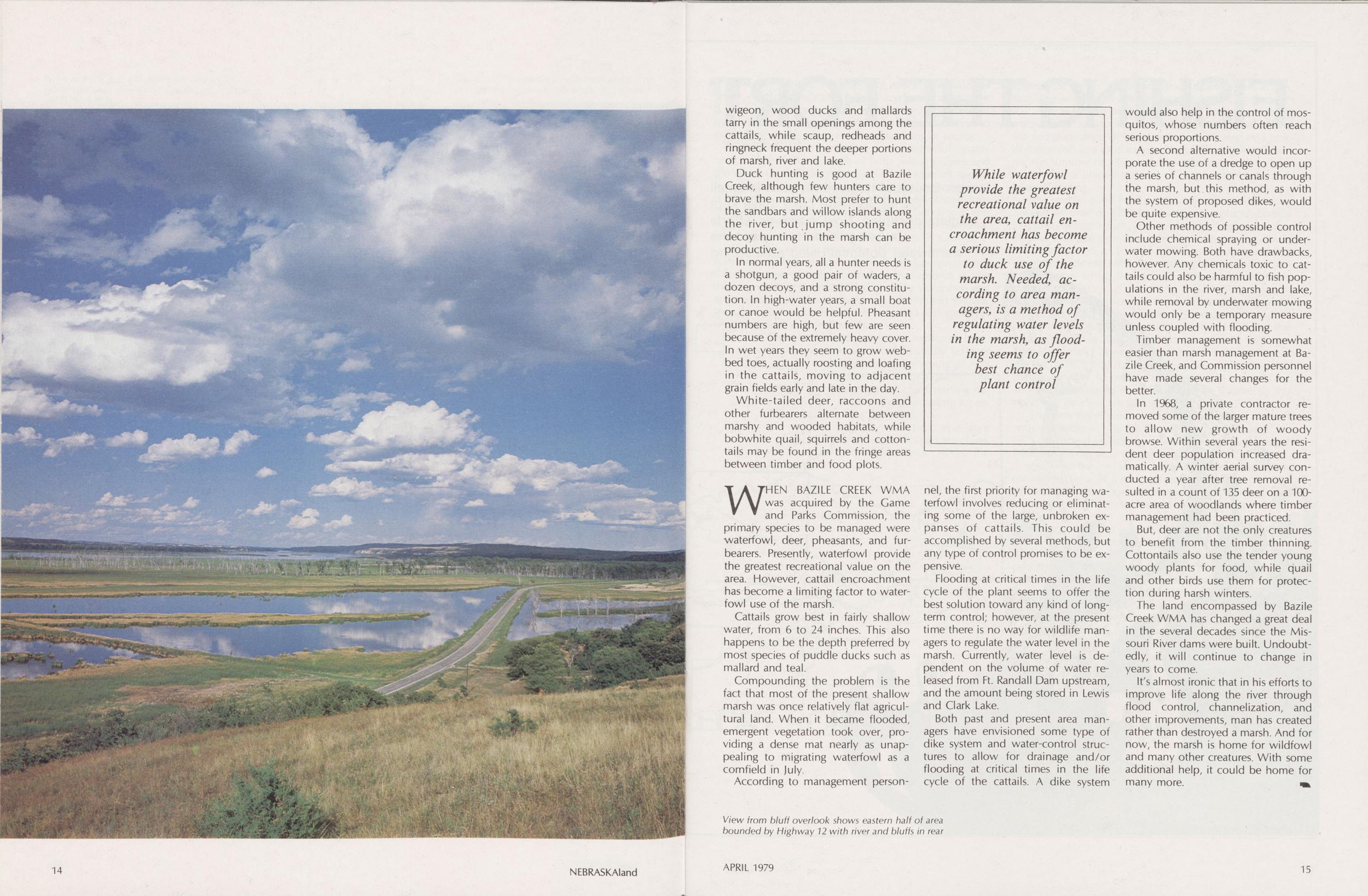
View from bluff overlook shows eastern half of area bounded by Highway 12 with river and bluffs in rear
Duck hunting is good at Bazile Creek, although few hunters care to brave the marsh. Most prefer to hunt the sandbars and willow islands along the river, but jump shooting and decoy hunting in the marsh can be productive.
In normal years, all a hunter needs is a shotgun, a good pair of waders, a dozen decoys, and a strong constitution. In high-water years, a small boat or canoe would be helpful. Pheasant numbers are high, but few are seen because of the extremely heavy cover. In wet years they seem to grow webbed toes, actually roosting and loafing in the cattails, moving to adjacent grain fields early and late in the day.
White-tailed deer, raccoons and other furbearers alternate between marshy and wooded habitats, while bobwhite quail, squirrels and cottontails may be found in the fringe areas between timber and food plots.
WHEN BAZILE CREEK WMA was acquired by the Game and Parks Commission, the primary species to be managed were waterfowl, deer, pheasants, and furbearers. Presently, waterfowl provide the greatest recreational value on the area. However, cattail encroachment has become a limiting factor to waterfowl use of the marsh.
Cattails grow best in fairly shallow water, from 6 to 24 inches. This also happens to be the depth preferred by most species of puddle ducks such as mallard and teal.
Compounding the problem is the fact that most of the present shallow marsh was once relatively flat agricultural land. When it became flooded, emergent vegetation took over, providing a dense mat nearly as unappealing to migrating waterfowl as a cornfield in July.
While waterfowl provide the greatest recreational value on the area, cattail encroachment has become a serious limiting factor to duck use of the marsh. Needed, according to area managers, is a method of regulating water levels in the marsh, as flooding seems to offer best chance of plant control
According to management personnel, the first priority for managing waterfowl involves reducing or eliminating some of the large, unbroken expanses of cattails. This could be accomplished by several methods, but any type of control promises to be expensive.
Flooding at critical times in the life cycle of the plant seems to offer the best solution toward any kind of long-term control; however, at the present time there is no way for wildlife managers to regulate the water level in the marsh. Currently, water level is dependent on the volume of water released from Ft. Randall Dam upstream, and the amount being stored in Lewis and Clark Lake.
Both past and present area managers have envisioned some type of dike system and water-control structures to allow for drainage and/or flooding at critical times in the life cycle of the cattails. A dike system would also help in the control of mosquitos, whose numbers often reach serious proportions.
A second alternative would incorporate the use of a dredge to open up a series of channels or canals through the marsh, but this method, as with the system of proposed dikes, would be quite expensive.
Other methods of possible control include chemical spraying or underwater mowing. Both have drawbacks, however. Any chemicals toxic to cattails could also be harmful to fish populations in the river, marsh and lake, while removal by underwater mowing would only be a temporary measure unless coupled with flooding.
Timber management is somewhat easier than marsh management at Bazile Creek, and Commission personnel have made several changes for the better.
In 1968, a private contractor removed some of the larger mature trees to allow new growth of woody browse. Within several years the resident deer population increased dramatically. A winter aerial survey conducted a year after tree removal resulted in a count of 135 deer on a 100-acre area of woodlands where timber management had been practiced.
But, deer are not the only creatures to benefit from the timber thinning. Cottontails also use the tender young woody plants for food, while quail and other birds use them for protection during harsh winters.
The land encompassed by Bazile Creek WMA has changed a great deal in the several decades since the Missouri River dams were built. Undoubtedly, it will continue to change in years to come.
It's almost ironic that in his efforts to improve life along the river through flood control, channelization, and other improvements, man has created rather than destroyed a marsh. And for now, the marsh is home for wildfowl and many other creatures. With some additional help, it could be home for many more.
14 NEBRASKAland APRIL 1979 15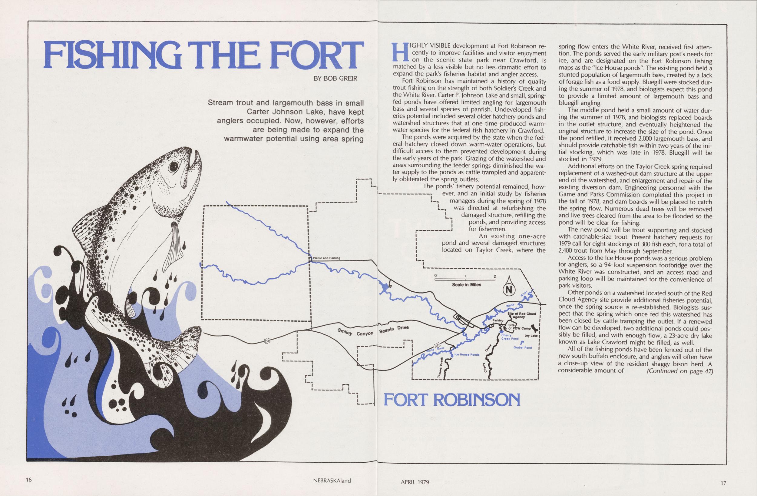
FISHING THE FORT
Stream trout and largemouth bass in small Carter Johnson Lake, have kept anglers occupied. Now, however, efforts are being made to expand the warmwater potential using area spring
HIGHLY VISIBLE development at Fort Robinson recently to improve facilities and visitor enjoyment on the scenic state park near Crawford, is matched by a less visible but no less dramatic effort to expand the park's fisheries habitat and angler access.
Fort Robinson has maintained a history of quality trout fishing on the strength of both Soldier's Creek and the White River. Carter P. Johnson Lake and small, spring-fed ponds have offered limited angling for largemouth bass and several species of panfish. Undeveloped fisheries potential included several older hatchery ponds and watershed structures that at one time produced warm-water species for the federal fish hatchery in Crawford.
The ponds were acquired by the state when the federal hatchery closed down warm-water operations, but difficult access to them prevented development during the early years of the park. Grazing of the watershed and areas surrounding the feeder springs diminished the water supply to the ponds as cattle trampled and apparently obliterated the spring outlets.
The ponds' fishery potential remained, however, and an initial study by fisheries managers during the spring of 1978 was directed at refurbishing the damaged structure, refilling the ponds, and providing access for fishermen.
An existing one-acre pond and several damaged structures located on Taylor Creek, where the spring flow enters the White River, received first attention. The ponds served the early military post's needs for ice, and are designated on the Fort Robinson fishing maps as the "Ice House ponds". The existing pond held a stunted population of largemouth bass, created by a lack of forage fish as a food supply. Bluegill were stocked during the summer of 1978, and biologists expect this pond to provide a limited amount of largemouth bass and bluegill angling.
The middle pond held a small amount of water during the summer of 1978, and biologists replaced boards in the outlet structure, and eventually heightened the original structure to increase the size of the pond. Once the pond refilled, it received 2,000 largemouth bass, and should provide catchable fish within two years of the initial stocking, which was late in 1978. Bluegill will be stocked in 1979.
Additional efforts on the Taylor Creek spring required replacement of a washed-out dam structure at the upper end of the watershed, and enlargement and repair of the existing diversion dam. Engineering personnel with the Game and Parks Commission completed this project in the fall of 1978, and dam boards will be placed to catch the spring flow. Numerous dead trees will be removed and live trees cleared from the area to be flooded so the pond will be clear for fishing.
The new pond will be trout supporting and stocked with catchable-size trout. Present hatchery requests for 1979 call for eight stockings of 300 fish each, for a total of 2,400 trout from May through September.
Access to the Ice House ponds was a serious problem for anglers, so a 94-foot suspension footbridge over the White River was constructed, and an access road and parking loop will be maintained for the convenience of park visitors.
Other ponds on a watershed located south of the Red Cloud Agency site provide additional fisheries potential, once the spring source is re-established. Biologists suspect that the spring which once fed this watershed has been closed by cattle tramping the outlet. If a renewed flow can be developed, two additional ponds could possibly be filled, and with enough flow, a 23-acre dry lake known as Lake Crawford might be filled, as well.
All of the fishing ponds have been fenced out of the new south buffalo enclosure, and anglers will often have a close-up view of the resident shaggy bison herd. A considerable amount of (Continued on page 47)
16 NEBRASKAland APRIL 1979 17
AND NOW...A FEW FACTS ABOUT PARKS
VISITATION, ACREAGE AND OPERATING COSTS HAVE CLIMBED STEADILY OVER YEARS
NEBRASKA'S State Parks System is a fascinating mix of fabulous scenery, intriguing history, sparkling lakes, rushing streams, modern campgrounds, wilderness trails, and much more.
All these things are easily discernible to the most casual park visitor. However, there are numerous little-known, but fascinating, facts about the park areas and their operation.
Actually, the state park concept, as it is known today, is a comparatively recent development. In 1921, only 19 of the 48 contiguous states had any parks at all. Of those 19 states, seven had only one park. Even California, which now has over 200 park areas, had only one then. In that same year, the Nebraska Legislature set aside one section (640 acres) of school land in Dawes County as a state park. That area in the Pine Ridge was Nebraska's first state park, and Chadron still delights many thousands of visitors each year.
Two years later, on recommendation of the park board, the Legislature accepted Arbor Lodge at Nebraska City as a gift to the people of Nebraska and appropriated $5,000 a year to maintain the property. Today, a mowing machine capable of maintaining the lawns there costs nearly the same amount as that total first appropriation.
Arbor Lodge provides a wealth of tidbits. The arboretum there boasts over 200 species of trees and shrubs, some dating back well over 100 years. The Englemann Spruce (with the stone collar around its trunk) is now 101 years old. Mrs. J. Sterling Morton brought it as a seedling in a tomato can from Pikes Peak in 1878 and planted it near the house.
In 1977, more than 20,000 trees and shrubs were planted on 30 Nebraska park areas. About 6,000 trees were grown and distributed from the Commission's central nursery at Grand Island. In addition, 12 field nurseries have been established on park areas, and some 2,000 plants were produced from seed or cuttings grown in Lincoln and at Arbor Lodge.
Sometimes, the statistics confronting park managers are mind-boggling. The boom in camping is a prime example. In 1971, some 78,180 paid campers registered at the park campgrounds. By 1977, that figure had skyrocketed to over 206,000. That figures out to 264 percent increase from just six years before.
Inflation, too, has park administrators gnashing their teeth, just as it does everyone else. One sample of the inflated cost of energy comes from the records for the purchase of propane for a shower building. In 1970, 1,200 gallons of propane to heat the facility cost $141.60. In 1978, the same amount of fuel to heat the same building had more than tripled to $432. Other costs have escalated about the same.
Obviously, park managers are confronting dual dilemmas... fantastic increases in usage of the park areas plus soaring costs of operating those areas on a level that provides visitors with an enjoyable park experience.
Some of the figures they deal with are a little more fun, though. In 1965, park crews made approximately 25,000 soil-cement blocks to construct the reproduction of the sod blacksmith-carpenter shop at Fort Kearny State Historical Park. Since then, over 1,000,000 visitors have passed through the structure for a peek at the past. That's many, many times the number of folks who ever worked in or came to the original shop to have work done.
So, the next time you visit a Nebraska park area and see a staff member, take a few moments to chat. They all have interesting stories to tell about "their" areas.
Scenic Rock Bluff Trail leads to overhang of Indian Cave
From Indian Cave in the southeast to Fort Robinson in the northwest, Nebraska's five major parks are the great getaway places. There's fun for the entire family ... whatever their inclinations. You can hike in splendid solitude or join the community-style fun of swimming, camping, trail riding, picnicking, and more.
Autumn enriches a trail ride through hills at Indian Cave
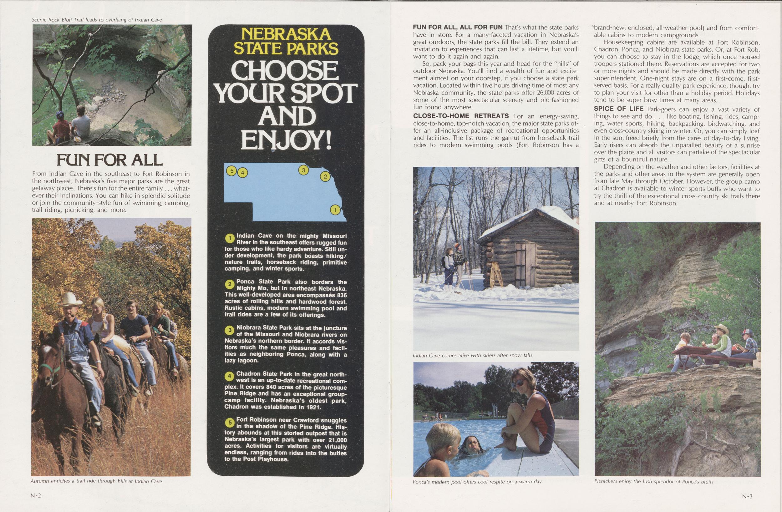
1 Indian Cave on the mighty Missouri River in the southeast offers rugged fun for those who like hardy adventure. Still under development, the park boasts hiking/nature trails, horseback riding, primitive camping, and winter sports.
2 Ponca State Park also borders the Mighty Mo, but in northeast Nebraska. This well-developed area encompasses 836 acres of rolling hills and hardwood forest. Rustic cabins, modern swimming pool and trail rides are a few of its offerings.
3 Niobrara State Park sits at the juncture of the Missouri and Niobrara rivers on Nebraska's northern border. It accords visitors much the same pleasures and facilities as neighboring Ponca, along with a lazy lagoon.
4 Chadron State Park in the great northwest is an up-to-date recreational complex. It covers 840 acres of the picturesque Pine Ridge and has an exceptional group-camp facility. Nebraska's oldest park, Chadron was established in 1921.
5 Fort Robinson near Crawford snuggles in the shadow of the Pine Ridge. History abounds at this storied outpost that is Nebraska's largest park with over 21,000 acres. Activities for visitors are virtually endless, ranging from rides into the buttes to the Post Playhouse.
FUN FOR ALL, ALL FOR FUN That's what the state parks have in store. For a many-faceted vacation in Nebraska's great outdoors, the state parks fill the bill. They extend an invitation to experiences that can last a lifetime, but you'll want to do it again and again.
So, pack your bags this year and head for the "hills" of outdoor Nebraska. You'll find a wealth of fun and excitement almost on your doorstep, if you choose a state park vacation. Located within five hours driving time of most any Nebraska community, the state parks offer 26,000 acres of some of the most spectacular scenery and old-fashioned fun found anywhere.
CLOSE-TO-HOME RETREATS For an energy saving, close-to-home, top-notch vacation, the major state parks offer an all-inclusive package of recreational opportunities and facilities. The list runs the gamut from horseback trail rides to modern swimming pools (Fort Robinson has a brand-new, enclosed, all-weather pool) and from comfortable cabins to modern campgrounds.
Housekeeping cabins are available at Fort Robinson, Chadron, Ponca, and Niobrara state parks. Or, at Fort Rob, you can choose to stay in the lodge, which once housed troopers stationed there. Reservations are accepted for two or more nights and should be made directly with the park superintendent. One-night stays are on a first-come, first-served basis. For a really quality park experience, though, try to plan your visit for other than a holiday period. Holidays tend to be super busy times at many areas.
SPICE OF LIFE Park-goers can enjoy a vast variety of things to see and do...like boating, fishing, rides, camping, water sports, hiking, backpacking, birdwatching, and even cross-country skiing in winter. Or, you can simply loaf in the sun, freed briefly from the cares of day-to-day living. Early risers can absorb the unparalled beauty of a sunrise over the plains and all visitors can partake of the spectacular gifts of a bountiful nature.
Depending on the weather and other factors, facilities at the parks and other areas in the system are generally open from late May through October. However, the group camp at Chadron is available to winter sports buffs who want to try the thrill of the exceptional cross-country ski trails there and at nearby Fort Robinson.
Indian Cave comes alive with skiers after snow falls
Ponca's modern pool offers cool respite on a warm day
Picnickers enjoy the lush splendor of Ponca's bluffs
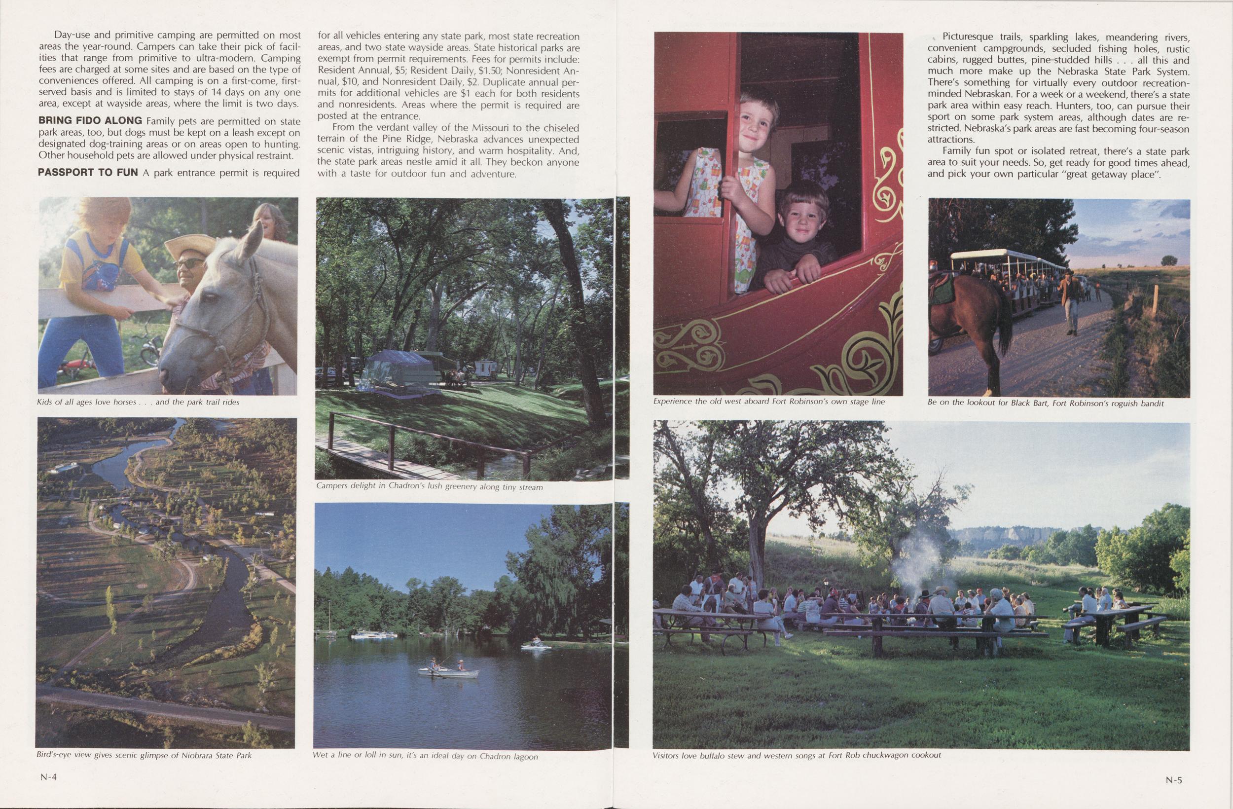
Day-use and primitive camping are permitted on most areas the year-round. Campers can take their pick of facilities that range from primitive to ultra-modern. Camping fees are charged at some sites and are based on the type of conveniences offered. All camping is on a first-come, first-served basis and is limited to stays of 14 days on any one area, except at wayside areas, where the limit is two days.
BRING FIDO ALONG Family pets are permitted on state park areas, too, but dogs must be kept on a leash except on designated dog-training areas or on areas open to hunting. Other household pets are allowed under physical restraint.
PASSPORT TO FUN A park entrance permit is required for all vehicles entering any state park, most state recreation areas, and two state wayside areas. State historical parks are exempt from permit requirements. Fees for permits include: Resident Annual, $5; Resident Daiiy, $1.50; Nonresident Annual, $10, and Nonresident Daily, $2. Duplicate annual permits for additional vehicles are $1 each for both residents and nonresidents. Areas where the permit is required are posted at the entrance.
From the verdant valley of the Missouri to the chiseled terrain of the Pine Ridge, Nebraska advances unexpected scenic vistas, intriguing history, and warm hospitality. And, the state park areas nestle amid it all. They beckon anyone with a taste for outdoor fun and adventure.
Picturesque trails, sparkling lakes, meandering rivers, convenient campgrounds, secluded fishing holes, rustic cabins, rugged buttes, pine-studded hills ... all this and much more make up the Nebraska State Park System. There's something for virtually every outdoor recreation-minded Nebraskan. For a week or a weekend, there's a state park area within easy reach. Hunters, too, can pursue their sport on some park system areas, although dates are restricted. Nebraska's park areas are fast becoming four-season attractions.
Family fun spot or isolated retreat, there's a state park area to suit your needs. So, get ready for good times ahead, and pick your own particular "great getaway place".
Kids of all ages love horses...and the park trail rides
Bird's-eye view gives scenic glimpse of Niobrara State Park
Campers delight in Chadron's lush greenery along tiny stream
Wet a line or loll in sun, it's an ideal day on Chadron lagoon
Experience the old west aboard Fort Robinson's own stage line
Be on the lookout for Black Bart, Fort Robinson's roguish bandit
Visitors love buffalo stew and western songs at Fort Rob chuckwagon cookout
 NEBRASKA STATE
HISTORICAL PARKS
Rich Past Lives On
NEBRASKA STATE
HISTORICAL PARKS
Rich Past Lives On
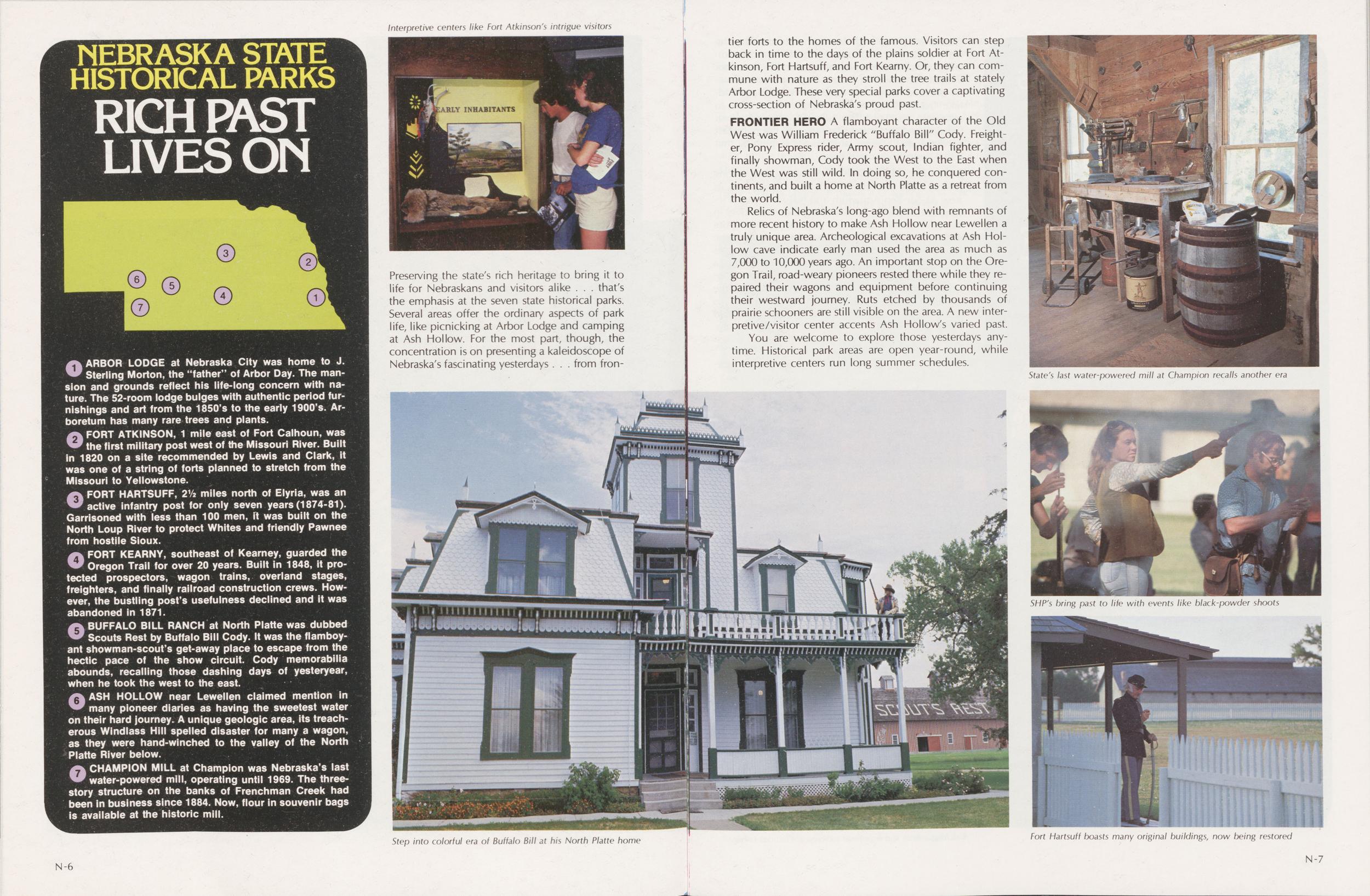
ARBOR LODGE at Nebraska City was home to J. Sterling Morton, the "father" of Arbor Day. The mansion and grounds reflect his life-long concern with nature. The 52-room lodge bulges with authentic period furnishings and art from the 1850s to the early 1900's. Arboretum has many rare trees and plants.
FORT ATKINSON, 1 mile east of Fort Calhoun, was the first military post west of the Missouri River. Built in 1820 on a site recommended by Lewis and Clark, it was one of a string of forts planned to stretch from the Missouri to Yellowstone.
FORT HARTSUFF, 21/2 miles north of Elyria, was an active infantry post for only seven years (1874-81). Garrisoned with less than 100 men, it was built on the North Loup River to protect Whites and friendly Pawnee from hostile Sioux.
FORT KEARNY, southeast of Kearney, guarded the Oregon Trail for over 20 years. Built in 1848, it protected prospectors, wagon trains, overland stages, freighters, and finally railroad construction crews. However, the bustling post's usefulness declined and it was abandoned in 1871.
BUFFALO BILL RANCH at North Platte was dubbed Scouts Rest by Buffalo Bill Cody. It was the flamboyant showman-scout's get-away place to escape from the hectic pace of the show circuit. Cody memorabilia abounds, recalling those dashing days of yesteryear, when he took the west to the east.
ASH HOLLOW near Lewellen claimed mention in many pioneer diaries as having the sweetest water on their hard journey. A unique geologic area, its treacherous Windlass Hill spelled disaster for many a wagon, as they were hand-winched to the valley of the North Platte River below.
CHAMPION MILL at Champion was Nebraska's last water-powered mill, operating until 1969. The three-story structure on the banks of Frenchman Creek had been in business since 1884. Now, flour in souvenir bags is available at the historic mill.
Interpretive centers like Fort Atkinson; intrigue visitors
Preserving the state's rich heritage to bring it to life for Nebraskans and visitors alike...that's the emphasis at the seven state historical parks. Several areas offer the ordinary aspects of park life, like picnicking at Arbor Lodge and camping at Ash Hollow. For the most part, though, the concentration is on presenting a kaleidoscope of Nebraska's fascinating yesterdays...from frontier forts to the homes of the famous. Visitors can step back in time to the days of the plains soldier at Fort Atkinson, Fort Hartsuff, and Fort Kearny. Or, they can commune with nature as they stroll the tree trails at stately Arbor Lodge. These very special parks cover a captivating cross-section of Nebraska's proud past.
FRONTIER HERO A flamboyant character of the Old West was William Frederick "Buffalo Bill" Cody. Freighter, Pony Express rider, Army scout, Indian fighter, and finally showman, Cody took the West to the East when the West was still wild. In doing so, he conquered continents, and built a home at North Platte as a retreat from the world.
Relics of Nebraska's long-ago blend with remnants of more recent history to make Ash Hollow near Lewellen a truly unique area. Archeological excavations at Ash Hollow cave indicate early man used the area as much as 7,000 to 10,000 years ago. An important stop on the Oregon Trail, road-weary pioneers rested there while they repaired their wagons and equipment before continuing their westward journey. Ruts etched by thousands of prairie schooners are still visible on the area. A new interpretive/visitor center accents Ash Hollow's varied past.
You are welcome to explore those yesterdays anytime. Historical park areas are open year-round, while interpretive centers run long summer schedules.
Step into colorful era of Buffalo Bill at his North Platte home
State's last water-powered mill at Champion recalls another era
SHP's bring past to life with events like black-powder shoots
Fort Hartsuff boasts many original buildings, now being restored
 NEBRASKA STATE
RECREATION AREAS
Family Fun Spots Dot the Landscape
NEBRASKA STATE
RECREATION AREAS
Family Fun Spots Dot the Landscape
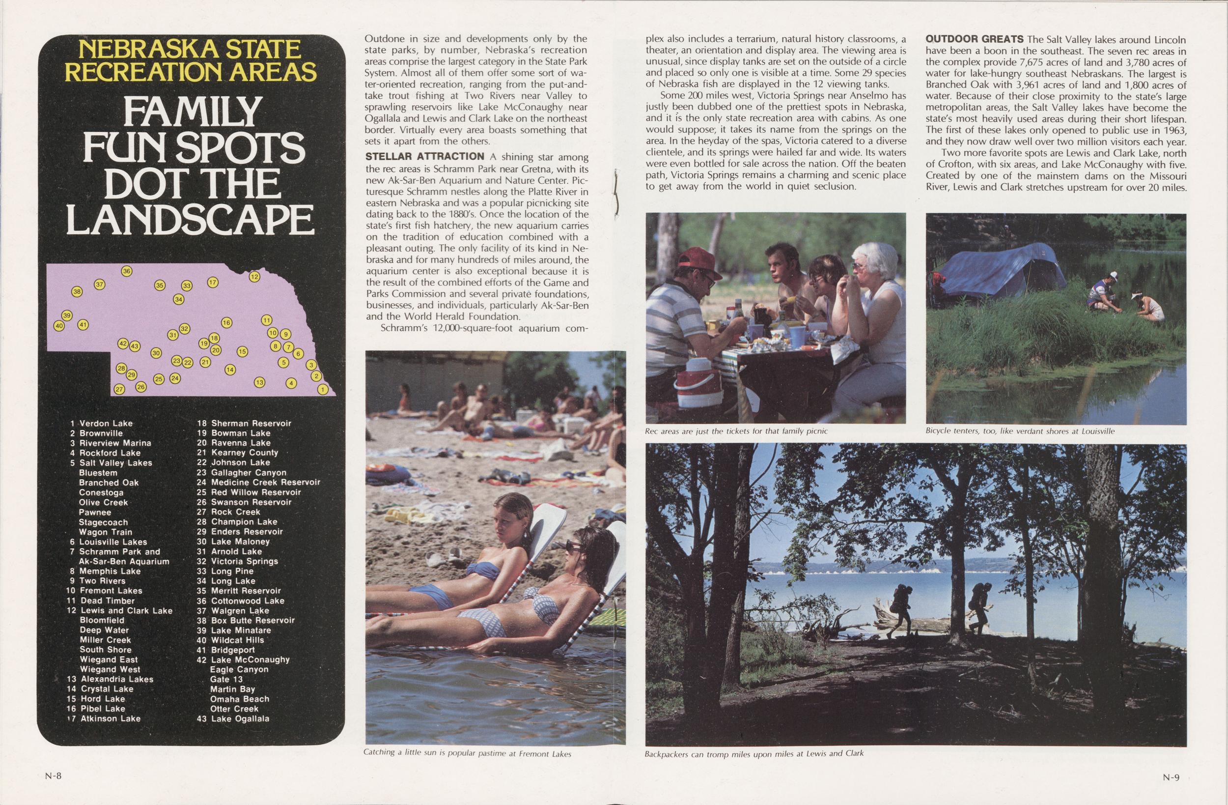
Outdone in size and developments only by the state parks, by number, Nebraska's recreation areas comprise the largest category in the State Park System. Almost all of them offer some sort of water-oriented recreation, ranging from the put-and-take trout fishing at Two Rivers near Valley to sprawling reservoirs like Lake McConaughy near Ogallala and Lewis and Clark Lake on the northeast border. Virtually every area boasts something that sets it apart from the others.
STELLAR ATTRACTION A shining star among the rec areas is Schramm Park near Gretna, with its new Ak-Sar-Ben Aquarium and Nature Center. Picturesque Schramm nestles along the Platte River in eastern Nebraska and was a popular picnicking site dating back to the 1880/s. Once the location of the state's first fish hatchery, the new aquarium carries on the tradition of education combined with a pleasant outing. The only facility of its kind in Nebraska and for many hundreds of miles around, the aquarium center is also exceptional because it is the result of the combined efforts of the Game and Parks Commission and several private foundations, businesses, and individuals, particularly Ak-Sar-Ben and the World Herald Foundation.
Schramm's 12,000-square-foot aquarium complex also includes a terrarium, natural history classrooms, a theater, an orientation and display area. The viewing area is unusual, since display tanks are set on the outside of a circle and placed so only one is visible at a time. Some 29 species of Nebraska fish are displayed in the 12 viewing tanks.
Some 200 miles west, Victoria Springs near Anselmo has justly been dubbed one of the prettiest spots in Nebraska, and it is the only state recreation area with cabins. As one would suppose; it takes its name from the springs on the area. In the heyday of the spas, Victoria catered to a diverse clientele, and its springs were hailed far and wide. Its waters were even bottled for sale across the nation. Off the beaten path, Victoria Springs remains a charming and scenic place to get away from the world in quiet seclusion.
OUTDOOR GREATS The Salt Valley lakes around Lincoln have been a boon in the southeast. The seven rec areas in the complex provide 7,675 acres of land and 3,780 acres of water for lake-hungry southeast Nebraskans. The largest is Branched Oak with 3,961 acres of land and 1,800 acres of water. Because of their close proximity to the state's large metropolitan areas, the Salt Valley lakes have become the state's most heavily used areas during their short lifespan. The first of these lakes only opened to public use in 1963, and they now draw well over two million visitors each year.
Catching a little sun is popular pastime at Fremont Lakes
Rec areas are just the tickets for that family picnic
Bicycle tenters, too, like verdant shores at Louisville
Backpackers can tromp miles upon miles at Lewis and Clark
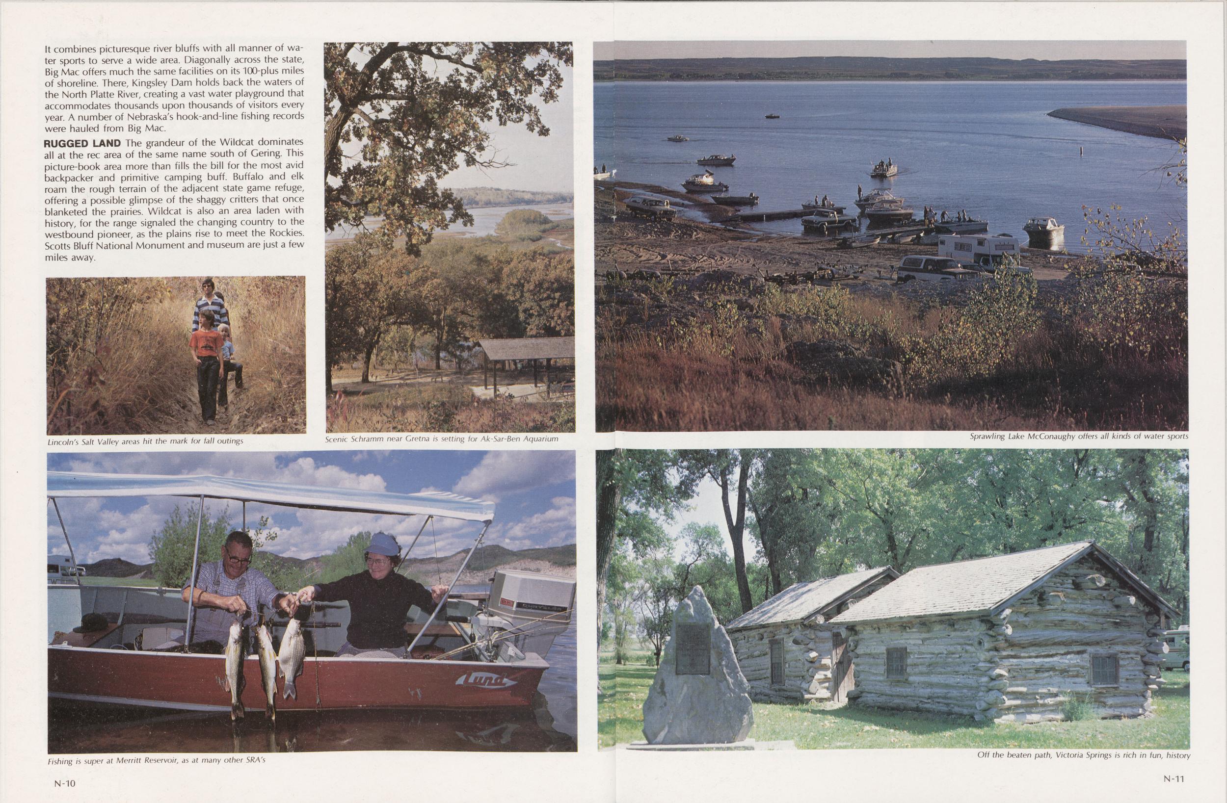 It combines picturesque river bluffs with all manner of water sports to serve a wide
area. Diagonally across the state,
Big Mac offers much the same facilities on its 100-plus miles
of shoreline. There, Kingsley Dam holds back the waters of
the North Platte River, creating a vast water playground that
accommodates thousands upon thousands of visitors every
year. A number of Nebraska's hook-and-line fishing records
were hauled from Big Mac.
It combines picturesque river bluffs with all manner of water sports to serve a wide
area. Diagonally across the state,
Big Mac offers much the same facilities on its 100-plus miles
of shoreline. There, Kingsley Dam holds back the waters of
the North Platte River, creating a vast water playground that
accommodates thousands upon thousands of visitors every
year. A number of Nebraska's hook-and-line fishing records
were hauled from Big Mac.Lincoln's Salt Valley areas hit the mark for fall outings
Scenic Schramm near Gretna is setting for Ak-Sar-Ben Aquarium
Sprawling Lake McConaughy offers all kinds of water sports
Fishing is super at Merritt Reservoir, as at many other SRA's
Off the beaten path, Victoria Springs is rich in fun, history
 Relax and break the tedium of a long drive, or just retreat
from the "hustle" for a few hours by picnicking with the
family. You can do just that at any of Nebraska's 23 state
wayside areas.
Relax and break the tedium of a long drive, or just retreat
from the "hustle" for a few hours by picnicking with the
family. You can do just that at any of Nebraska's 23 state
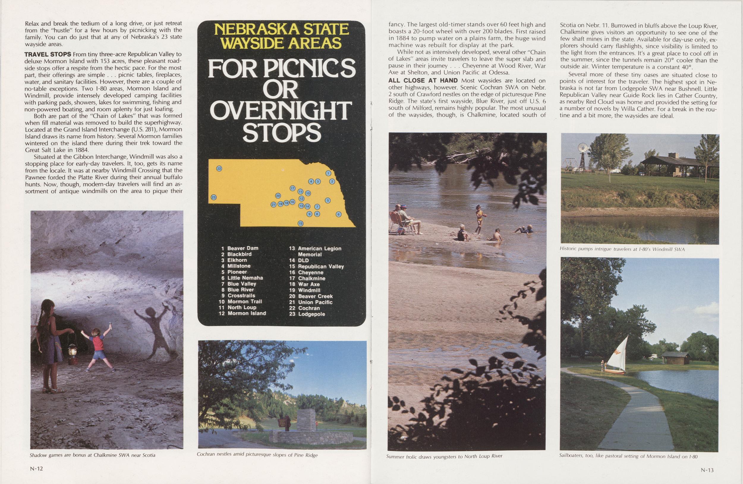
wayside areas.TRAVEL STOPS From tiny three-acre Republican Valley to deluxe Mormon Island with 153 acres, these pleasant roadside stops offer a respite from the hectic pace. For the most part, their offerings are simple...picnic tables, fireplaces, water, and sanitary facilities. However, there are a couple of no-table exceptions. Two I-80 areas, Mormon Island and Windmill, provide intensely developed camping facilities with parking pads, showers, lakes for swimming, fishing and non-powered boating, and room aplenty for just loafing.
Both are part of the "Chain of Lakes" that was formed when fill material was removed to build the superhighway. Located at the Grand Island Interchange (U.S. 281), Mormon Island draws its name from history. Several Mormon families wintered on the island there during their trek toward the Great Salt Lake in 1884.
Situated at the Gibbon Interchange, Windmill was also a stopping place for early-day travelers. It, too, gets its name from the locale. It was at nearby Windmill Crossing that the Pawnee forded the Platte River during their annual buffalo hunts. Now, though, modern-day travelers will find an assortment of antique windmills on the area to pique their fancy. The largest old-timer stands over 60 feet high and boasts a 20-foot wheel with over 200 blades. First raised in 1884 to pump water on a plains farm, the huge wind machine was rebuilt for display at the park.
NEBRASKA STATE WAYSIDE AREAS For Picnics or Overnight Stops 1 Beaver Dam 2 Blackbird 3 Elkhorn 4 Millstone 5 Pioneer 6 Little Nemaha 7 Blue Valley 8 Blue River 9 Crosstrails 10 Mormon Trail 11 North Loup 12 Mormon Island 13 American Legion Memorial 14 DLD 15 Republican Valley 16 Cheyenne 17 Chalkmine 18 War Axe 19 Windmill 20 Beaver Creek 21 Union Pacific 22 Cochran 23 LodgepoleShadow games are bonus at Chalkmine SWA near Scotia
Cochran nestles amid picturesque slopes of Pine Ridge
While not as intensively developed, several other "Chain of Lakes" areas invite travelers to leave the super slab and pause in their journey...Cheyenne at Wood River, War Axe at Shelton, and Union Pacific at Odessa.
ALL CLOSE AT HAND Most waysides are located on other highways, however. Scenic Cochran SWA on Nebr. 2 south of Crawford nestles on the edge of picturesque Pine Ridge. The state's first wayside, Blue River, just off U.S. 6 south of Milford, remains highly popular. The most unusual of the waysides, though, is Chalkmine, located south of Scotia on Nebr. 11. Burrowed in bluffs above the Loup River, Chalkmine gives visitors an opportunity to see one of the few shaft mines in the state. Available for day-use only, explorers should carry flashlights, since visibility is limited to the light from the entrances. It's a great place to cool off in the summer, since the tunnels remain 20° cooler than the outside air. Winter temperature is a constant 40°.
Several more of these tiny oases are situated close to points of interest for the traveler. The highest spot in Nebraska is not far from Lodgepole SWA near Bushnell. Little Republican Valley near Guide Rock lies in Cather Country, as nearby Red Cloud was home and provided the setting for a number of novels by Willa Cather. For a break in the routine and a bit more, the waysides are ideal.
Summer frolic draws youngsters to North Loup River
Historic pumps intrigue travelers at ISO's Windmill SWA
Sailboaters, too, like pastoral setting of Mormon Island on 1-80
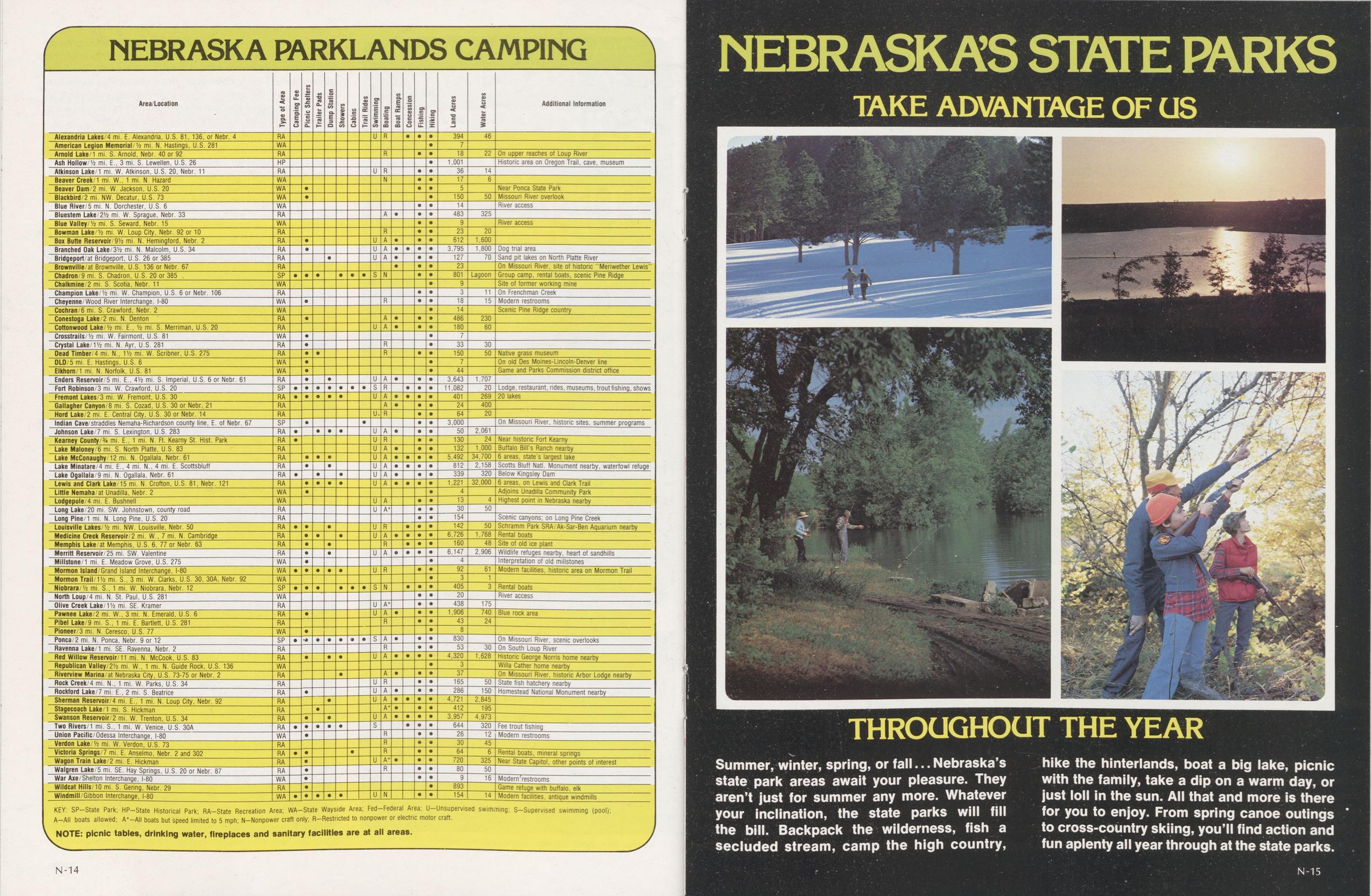
NEBRASKA PARKLANDS CAMPING
Area/Location Lion Additional Information Alexandria Lakes/4 mi. E. Alexandria, U.S. 81, 136, or Nebr. 4 RA American Legion Memorial/V2 mi. N. Hastings, U.S. 281 WA Arnold Lake/1 mi. S. Arnold, Nebr. 40 or 92 RA On upper reaches of Loup River Ash Hollow/y2 mi. E., 3 mi. S. Lewellen, U.S. 26 HP 1,001 Historic area on Oregon Trail, cave, museum Atkinson Lake/1 mi. W. Atkinson, U.S. 20, Nebr. 11 RA Beaver Creek/1 mi. W., 1 mi. N. Hazard WA Beaver Dam/2 mi. W. Jackson, U.S. 20 WA Near Ponca State Park Blackbird/2 mi. NW. Decatur, U.S. 73 WA Missouri River overlook Blue River/5 mi. N. Dorchester, U.S. 6 WA River access Bluestem Lake/21/2 mi. W. Sprague, Nebr. 33 RA 483 325 Blue Valley/Vz mi. S. Seward, Nebr. 15 WA River access Bowman Lake/1/2 mi. W. Loup City, Nebr. 92 or 10 RA Box Butte Reservoir/91/2 mi. N. Hemingford, Nebr. 2 RA 612 1,600 Branched Oak Lake/31/2 mi. N. Malcolm, U.S. 34 RA 3,795 1,800 Dog trial area Bridgeport/at Bridgeport, U.S. 26 or 385 RA 127 70 Sand pit lakes on North Platte River Brownville/at Brownville, U.S. 136 or Nebr. 67 RA On Missouri River, site of historic "Meriwether Lewis" Chadron/9 mi. S. Chadron, U.S. 20 or 385 SP Lagoon Group camp, rental boats, scenic Pine Ridge Chalkmine/2 mi. S. Scotia, Nebr. 11 WA Site of former working mine Champion Lake/1/2 mi. W. Champion, U.S. 6 or Nebr. 106 RA On Frenchman Creek Cheyenne/Wood River Interchange, I-80 WA 18 15 Modern restrooms Cochran/6 mi. S. Crawford, Nebr. 2 WA 14 Scenic Pine Ridge country Conestoga Lake/2 mi. N. Denton RA 486 230 Cottonwood Lake/1/2 mi. E., V2 mi. S. Merriman, U.S. 20 RA Crosstrails/1/2 mi. W. Fairmont, U.S. 81 WA Crystal Lake/11/2 mi. N. Ayr, U.S. 281 RA 33 30 150 50 Native grass museum DLD/5 mi. E. Hastings, U.S. 6 WA On old Des Moines-Lincoln-Denver line Elkhorn/1 mi. N. Norfolk, U.S. 81 WA Game and Parks Commission district office Enders Reservoir/5 mi. E., 41/2 mi. S. Imperial, U.S. 6 or Nebr. 61 RA 3,643 1,707 Fort Robinson/3 mi. W. Crawford, U.S. 20 11,082 20 Lodge, restaurant, rides, museums, trout fishing, shows Fremont Lakes/3 mi. W. Fremont, U.S. 30 RA 401 269 20 lakes Gallagher Canyon/8 mi. S. Cozad, U.S. 30 or Nebr. 21 RA 24 400 Hord Lake/2 mi. E. Central City, U.S. 30 or Nebr. 14 RA 64 20 Indian Cave/straddles Nemaha-Richardson county line, E. of Nebr. 67 SP 3,000 On Missouri River, historic sites, summer programs Johnson Lake/7 mi. S. Lexington, U.S. 283 RA 50 2,061 Kearney County/% mi. E., 1 mi. N. Ft. Kearny St. Hist. Park RA 130 24 Near historic Fort Kearny Lake Maloney/6 mi. S. North Platte, U.S. 83 RA 132 1,000 Buffalo Bill's Ranch nearby Lake McConaughy/12 mi. N. Ogallala. Nebr. 61 RA 5,492 34,700 6 areas, state's largest lake Lake Minatare/4 mi. E., 4 mi. N., 4 mi. E. Scottsbluff RA 812 2,158 Scotts Bluff Natl. Monument nearby, waterfowl refuge Lake Ogallala 9 mi. N. Ogallala, Nebr. 61 RA 339 320 Below Kingsley Dam Lewis and Clark Lake/15 mi. N. Crofton, U.S. 81, Nebr. 121 RA 1,221 32,000 6 areas, on Lewis and Clark Trail Little Nemaha/at Unadilla, Nebr. 2 WA Adjoins Unadilla Community Park Lodgepole 4 mi. E. Bushnell WA Highest point in Nebraska nearby Long Lake/20 mi. SW. Johnstown, county road RA 30 50 Long Pine/1 mi. N. Long Pine, U.S. 20 RA Scenic canyons; on Long Pine Creek Louisville Lakes/Vz mi. NW. Louisville, Nebr. 50 RA 142 50 Schramm Park SRA Ak-Sar-Ben Aquarium nearby Medicine Creek Reservoir/2 mi. W., 7 mi. N. Cambridge RA 6,726 1,768 Rental boats Memphis Lake/at Memphis, U.S. 6, 77 or Nebr. 63 RA 160 48 Site of old ice plant Merritt Reservoir/25 mi. SW. Valentine RA 6,147 2,906 Wildlife refuges nearby, heart of sandhills Millstone/1 mi. E. Meadow Grove, U.S. 275 WA Interpretation of old millstones Mormon Island/Grand Island Interchange, I-80 WA 92 61 Modern facilities, historic area on Mormon Trail Mormon Trail/11/2 mi. S., 3 mi. W. Clarks, U.S. 30, 30A, Nebr. 92 WA Niobrara/1/2 mi. S., 1 mi. W. Niobrara, Nebr. 12 SP 405 3 Rental boats North Loup/4 mi. N. St. Paul, U.S. 281 WA 20 River access Olive Creek Lake/11/2 mi. SE. Kramer RA 438 175 Pawnee Lake/2 mi. W., 3 mi. N. Emerald, U.S. 6 RA 1,906 740 Blue rock area Pibel Lake/9 mi. S., 1 mi. E. Bartlett, U.S. 281 RA 43 24 Pioneer/3 mi. N. Ceresco, U.S. 77 WA Ponca/2 mi. N. Ponca, Nebr. 9 or 12 SP 830 On Missouri River, scenic overlooks Ravenna Lake/1 mi. SE. Ravenna, Nebr. 2 RA On South Loup River Red Willow Reservoir/11 mi. N. McCook, U.S. 83 RA 4,320 1,628 Historic George Norris home nearby Republican Valley/2V2 mi. W., 1 mi. N. Guide Rock, U.S. 136 WA Willa Cather home nearby Riverview Marina/at Nebraska City, U.S. 73-75 or Nebr. 2 RA Un Missouri River, historic Arbor Lodge nearby Rock Creek/4 mi. N., 1 mi. W. Parks, U.S. 34 RA 165 50 State fish hatchery nearby Rockford Lake/7 mi. E., 2 mi. S. Beatrice RA 286 150 Homestead National Monument nearby Sherman Reservoir/4 mi. E., 1 mi. N. Loup City, Nebr. 92 RA 4,721 2,845 Stagecoach Lake/1 mi. S. Hickman RA 412 195 Swanson Reservoir/2 mi. W. Trenton, U.S. 34 RA 3,957 4,973 Two Rivers/1 mi. S., 1 mi. W. Venice, U.S. 30A RA 644 320 Fee trout fishinq Union Pacific/Odessa Interchange, I-80 WA 26 12 Modern restrooms Verdon Lake/1/2 mi. W. Verdon, U.S. 73 RA 30 45 Victoria Springs/7 mi. E. Anselmo, Nebr. 2 and 302 RA 64 6 Rental boats, mineral springs Wagon Train Lake/2 mi. E. Hickman RA 720 325 Near State Capitol, other points of interest Walgren Lake/5 mi. SE. Hay Sprinqs, U.S. 20 or Nebr. 87 RA 80 50 War Axe/Shelton Interchange, I-80 WA 9 16 Modern restrooms Wildcat Hills/10 mi. S. Gering, Nebr. 29 RA 893 Game refuge with buffalo, elk Windmill/Gibbon Interchange, I-80 WA 154 14 Modern facilities, antique windmills KEY: SP-State Park; HP-State Historical Park; RA-State Recreation A A-AII boats allowed; All boats but speed limited to 5 mph; Unsupervised craft. swimming; S—Supervised swimming (pool); NOTE: picnic tables, drinking water, fireplaces and sanitary facilities are at all areas.Nebraska's State Parks
TAKE ADVANTAGE OF US THROUGHOUT THE YEAR
Summer, winter, spring, or fall... Nebraska's state park areas await your pleasure. They aren't just for summer any more. Whatever your inclination, the state parks will fill the bill. Backpack the wilderness, fish a secluded stream, camp the high country, hike the hinterlands, boat a big lake, picnic with the family, take a dip on a warm day, or just loll in the sun. All that and more is there for you to enjoy. From spring canoe outings to cross-country skiing, you'll find action and fun aplenty all year through at the state parks.
N-14 N-15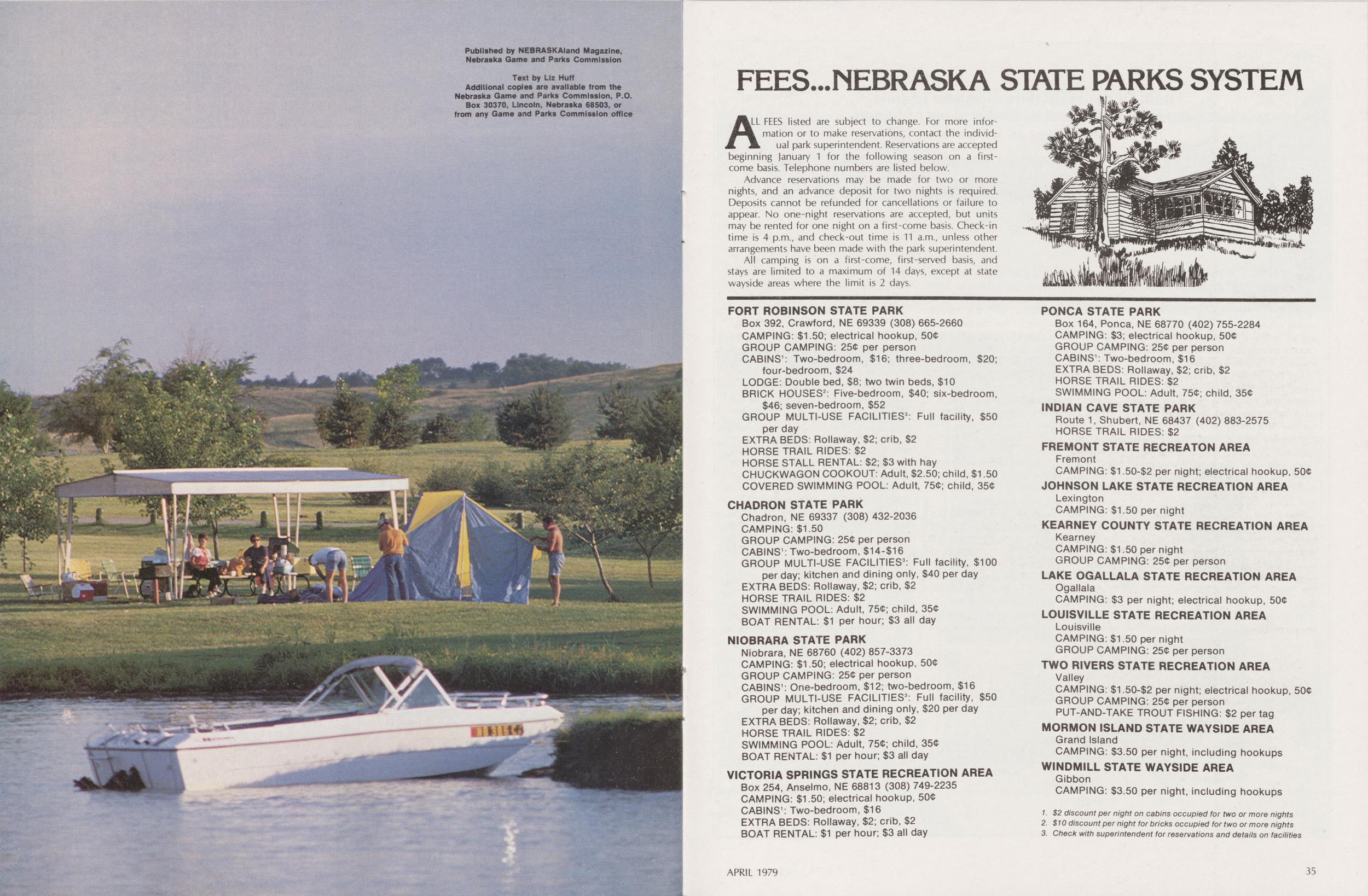
Published by NEBRASKAland Magazine, Nebraska Game and Parks Commission. Text by Liz Huff Additional copies are available from the Nebraska Game and parks Commission, P.O. Box. 30370, Lincoln, Nebraska 68503, or from any Game and Parks Commission office
FEES...NEBRASKA STATE PARKS SYSTEM
ALL FEES listed are subject to change. For more information or to make reservations, contact the individual manual park superintendent. Reservations are accepted beginning January 1 for the following season on a first-come basis. Telephone numbers are listed below.
Advance reservations may be made for two or more nights, and an advance deposit for two nights is required. Deposits cannot be refunded for cancellations or failure to appear. No one-night reservations are accepted, but units may be rented for one night on a first-come basis. Check-in time is 4 p.m., and check-out time is 11 a.m., unless other arrangements have been made with the park superintendent.
All camping is on a first-come, first-served basis, and stays are limited to a maximum of 14 days, except at state wayside areas where the limit is 2 days.
NIOBRARA STATE PARK Niobrara, NE 68760 (402) 857-3373 CAMPING: $1.50; electrical hookup, 50$ GROUP CAMPING: 25$ per person CABINS1: One-bedroom, $12; two-bedroom, $16 GROUP MULTI-USE FACILITIES3: Full facility, $50 per day; kitchen and dining only, $20 per day EXTRA BEDS: Rollaway, $2; crib, $2 HORSE TRAIL RIDES: $2 SWIMMING POOL: Adult, 75$; child, 35$ BOAT RENTAL: $1 per hour; $3 all day
VICTORIA SPRINGS STATE RECREATION AREA Box 254, Anselmo, NE 68813 (308) 749-2235 CAMPING: $1.50; electrical hookup, 50$ CABINS1: Two-bedroom, $16 EXTRA BEDS: Rollaway, $2; crib, $2 BOAT RENTAL: $1 per hour; $3 all day
PONCA STATE PARK Box 164, Ponca, NE 68770 (402) 755-2284 CAMPING: $3; electrical hookup, 50$ GROUP CAMPING: 25$ per person CABINS1: Two-bedroom, $16 EXTRA BEDS: Rollaway, $2; crib, $2 HORSE TRAIL RIDES: $2 SWIMMING POOL: Adult, 75$; child, 35$
INDIAN CAVE STATE PARK Route 1, Shubert, NE 68437 (402) 883-2575 HORSE TRAIL RIDES: $2
FREMONT STATE RECREATON AREA Fremont CAMPING: $1.50-$2 per night; electrical hookup, 50$
JOHNSON LAKE STATE RECREATION AREA Lexington CAMPING: $1.50 per night
KEARNEY COUNTY STATE RECREATION AREA Kearney CAMPING: $1.50 per night GROUP CAMPING: 25$ per person
LAKE OGALLALA STATE RECREATION AREA Ogallala CAMPING: $3 per night; electrical hookup, 50$
LOUISVILLE STATE RECREATION AREA Louisville CAMPING: $1.50 per night GROUP CAMPING: 25$ per person
TWO RIVERS STATE RECREATION AREA Valley CAMPING: $1.50-$2 per night; electrical hookup, 50$ GROUP CAMPING: 25$ per person PUT-AND-TAKE TROUT FISHING: $2 per tag
MORMON ISLAND STATE WAYSIDE AREA Grand Island CAMPING: $3.50 per night, including hookups
WINDMILL STATE WAYSIDE AREA Gibbon CAMPING: $3.50 per night, including hookups
1. $2 discount per night on cabins occupied for two or more nights 2. $10 discount per night for bricks occupied for two or more nights 3. Check with superintendent for reservations and details on facilities APRIL 1979 35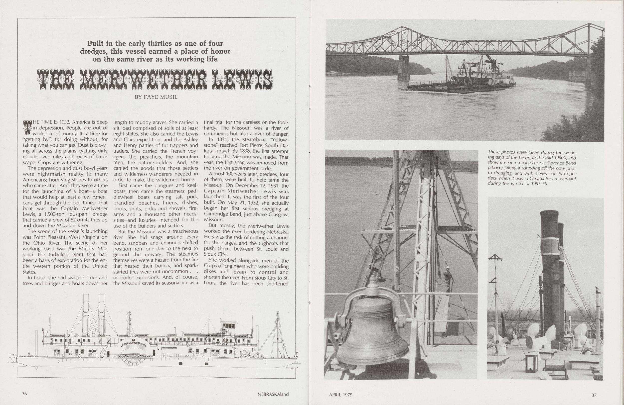
The Meriwether Lewis
Built in the early thirties as one of four dredges, this vessel earned a place of honor on the same river as its working lifeTHE TIME IS 1932. America is deep cafin depression. People are out of work, out of money. Its a time for "getting by", for doing without, for taking what you can get. Dust is blowing all across the plains, wafting dirty clouds over miles and miles of landscape. Crops are withering.
The depression and dust bowl years were nightmarish reality to many Americans; horrifying stories to others who came after. And, they were a time for the launching of a boat—a boat that would help at least a few Americans get through the bad times. That boat was the Captain Meriwether Lewis, a 1,500-ton "dustpan" dredge that carried a crew of 52 on its trips up and down the Missouri River.
The scene of the vessel's launching was Point Pleasant, West Virginia on the Ohio River. The scene of her working days was the Mighty Missouri, the turbulent giant that had been a basis of exploration for the entire western portion of the United States.
In flood, she had swept homes and trees and bridges and boats down her length to muddy graves. She carried a silt load comprised of soils of at least eight states. She also carried the Lewis and Clark expedition, and the Ashley and Henry parties of fur trappers and traders. She carried the French voyagers, the preachers, the mountain men, the nation-builders. And, she carried the goods that those settlers and wilderness-wanderers needed in order to make the wilderness home.
First came the pirogues and keelboats, then came the steamers; paddlewheel boats carrying salt pork, brandied peaches, linens, dishes, boots, shirts, picks and shovels, firearms and a thousand other necessities—and luxuries-intended for the use of the builders and settlers.
But the Missouri was a treacherous river. She hid snags around every bend, sandbars and channels shifted position from one day to the next to ground the unwary. The steamers themselves were a hazard from the fire that heated their boilers, and spark-started fires were not uncommon... or boiler explosions. And, of course, the Missouri saved its seasonal ice as a final trial for the careless or the foolhardy. The Missouri was a river of commerce, but also a river of danger.
In 1831, the steamboat "Yellowstone" reached Fort Pierre, South Dakota-intact. By 1838, the first attempt to tame the Missouri was made. That year, the first snag was removed from the river on government order.
Almost 100 years later, dredges, four of them, were built to help tame the Missouri. On December 12, 1931, the Captain Meriwether Lewis was launched. It was the first of the four built. On May 21, 1932, she actually began her first serious dredging at Cambridge Bend, just above Glasgow, Missouri.
But mostly, the Meriwether Lewis worked the river bordering Nebraska. Hers was the task of cutting a channel for the barges, and the tugboats that push them, between St. Louis and Sioux City.
These photos were taken during the working days of the Lewis, in the mid 1950% and show it near a service base at Florence Bend (above) taking a sounding off the bow prior to dredging, and with a view of its upper deck when it was in Omaha for an overhaul during the winter of 1955-56
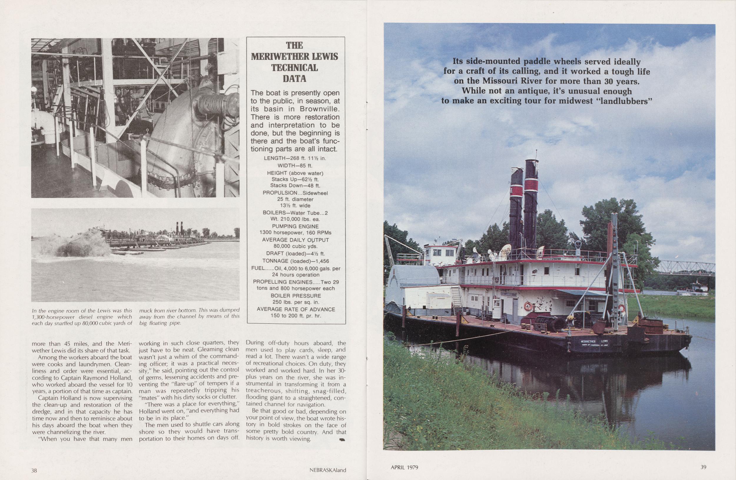
In the engine room of the Lewis was this 7,300-horsepower diesel engine which each day snarffed up 80,000 cubic yards of muck from river bottom. This was dumped away from the channel by means of this big floating pipe.
Among the workers aboard the boat were cooks and laundrymen. Cleanliness and order were essential, according to Captain Raymond Holland, who worked aboard the vessel for 10 years, a portion of that time as captain.
Captain Holland is now supervising the clean-up and restoration of the dredge, and in that capacity he has time now and then to reminisce about his days aboard the boat when they were channelizing the river.
"When you have that many men working in such close quarters, they just have to be neat. Gleaming clean wasn't just a whim of the commanding officer; it was a practical necessity," he said, pointing out the control of germs, lessening accidents and preventing the "flare-up" of tempers if a man was repeatedly tripping his "mates" with his dirty socks or clutter.
"There was a place for everything," Holland went on, "and everything had to be in its place."
The men used to shuttle cars along shore so they would have transportation to their homes on days off. During off-duty hours aboard, the men used to play cards, sleep, and read a lot. There wasn't a wide range of recreational choices. On duty, they worked and worked hard. In her 30-plus years on the river, she was instrumental in transforming it from a treacherous, shifting, snag-filled, flooding giant to a straightened, contained channel for navigation.
Be that good or bad, depending on your point of view, the boat wrote history in bold strokes on the face of some pretty bold country. And that history is worth viewing.
THE MERIWETHER LEWIS TECHNICAL DATA The boat is presently open to the public, in season, at its basin in Brownville. There is more restoration and interpretation to be done, but the beginning is there and the boat's functioning parts are all intact. LENGTH-268 ft. 111/2 in. WIDTH-85 ft. HEIGHT (above water) Stacks Up-621/2 ft. Stacks Down—48 ft. PROPULSION...Sidewheel 25 ft. diameter 131/2 ft. wide BOILERS-Water Tube...2 Wt. 210,000 lbs. ea. PUMPING ENGINE 1300 horsepower, 160 RPMs AVERAGE DAILY OUTPUT 80,000 cubic yds. DRAFT (loaded)-41/2 ft. TONNAGE (loaded)-1,456 FUEL Oil, 4,000 to 6,000 gals, per 24 hours operation PROPELLING ENGINES Two 29 tons and 800 horsepower each BOILER PRESSURE 250 lbs. per sq. in. AVERAGE RATE OF ADVANCE 150 to 200 ft. pr. hr.Its side-mounted paddle wheels served ideally for a craft of its calling, and it worked a tough life on the Missouri River for more than 30 years. While not an antique, it's unusual enough to make an exciting tour for midwest "landlubbers"
PARKS PERMITS
AN INVESTMENT IN TOMORROW
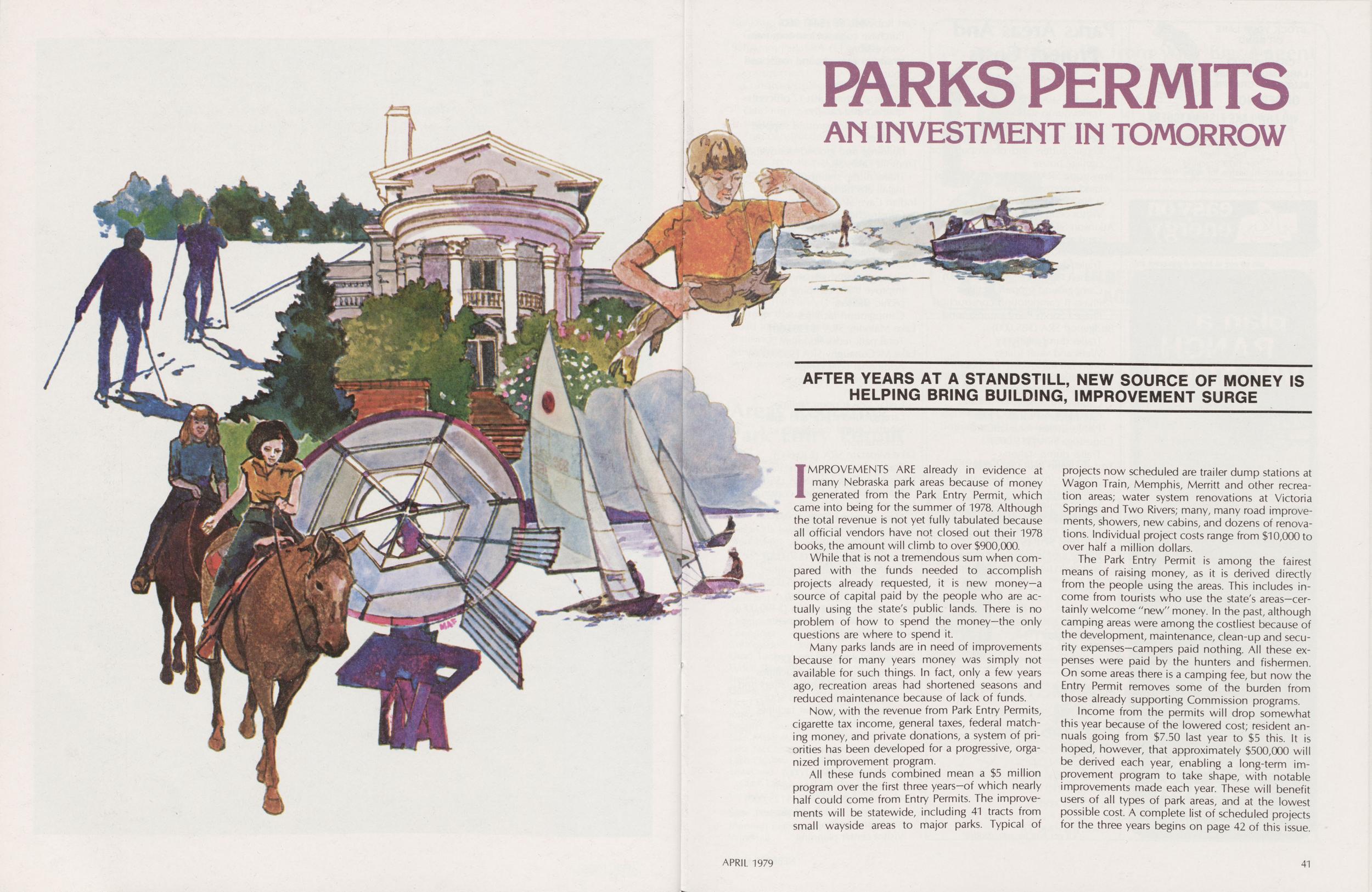
AFTER YEARS AT A STANDSTILL, NEW SOURCE OF MONEY IS HELPING BRING BUILDING, IMPROVEMENT SURGEIMPROVEMENTS ARE already in evidence at many Nebraska park areas because of money generated from the Park Entry Permit, which came into being for the summer of 1978. Although the total revenue is not yet fully tabulated because all official vendors have not closed out their 1978 books, the amount will climb to over $900,000.
While that is not a tremendous sum when compared with the funds needed to accomplish projects already requested, it is new money—a source of capital paid by the people who are actually using the state's public lands. There is no problem of how to spend the money—the only questions are where to spend it.
Many parks lands are in need of improvements because for many years money was simply not available for such things. In fact, only a few years ago, recreation areas had shortened seasons and reduced maintenance because of lack of funds.
Now, with the revenue from Park Entry Permits, cigarette tax income, general taxes, federal matching money, and private donations, a system of priorities has been developed for a progressive, organized improvement program.
All these funds combined mean a $5 million program over the first three years—of which nearly half could come from Entry Permits. The improvements will be statewide, including 41 tracts from small wayside areas to major parks. Typical of projects now scheduled are trailer dump stations at Wagon Train, Memphis, Merritt and other recreation areas; water system renovations at Victoria Springs and Two Rivers; many, many road improvements, showers, new cabins, and dozens of renovations. Individual project costs range from $10,000 to over half a million dollars.
The Park Entry Permit is among the fairest means of raising money, as it is derived directly from the people using the areas. This includes income from tourists who use the state's areas—certainly welcome "new" money. In the past, although camping areas were among the costliest because of the development, maintenance, clean-up and security expenses—campers paid nothing. All these expenses were paid by the hunters and fishermen. On some areas there is a camping fee, but now the Entry Permit removes some of the burden from those already supporting Commission programs.
Income from the permits will drop somewhat this year because of the lowered cost; resident annuals going from $7.50 last year to $5 this. It is hoped, however, that approximately $500,000 will be derived each year, enabling a long-term improvement program to take shape, with notable improvements made each year. These will benefit users of all types of park areas, and at the lowest possible cost. A complete list of scheduled projects for the three years begins on page 42 of this issue.
APRIL 1979 41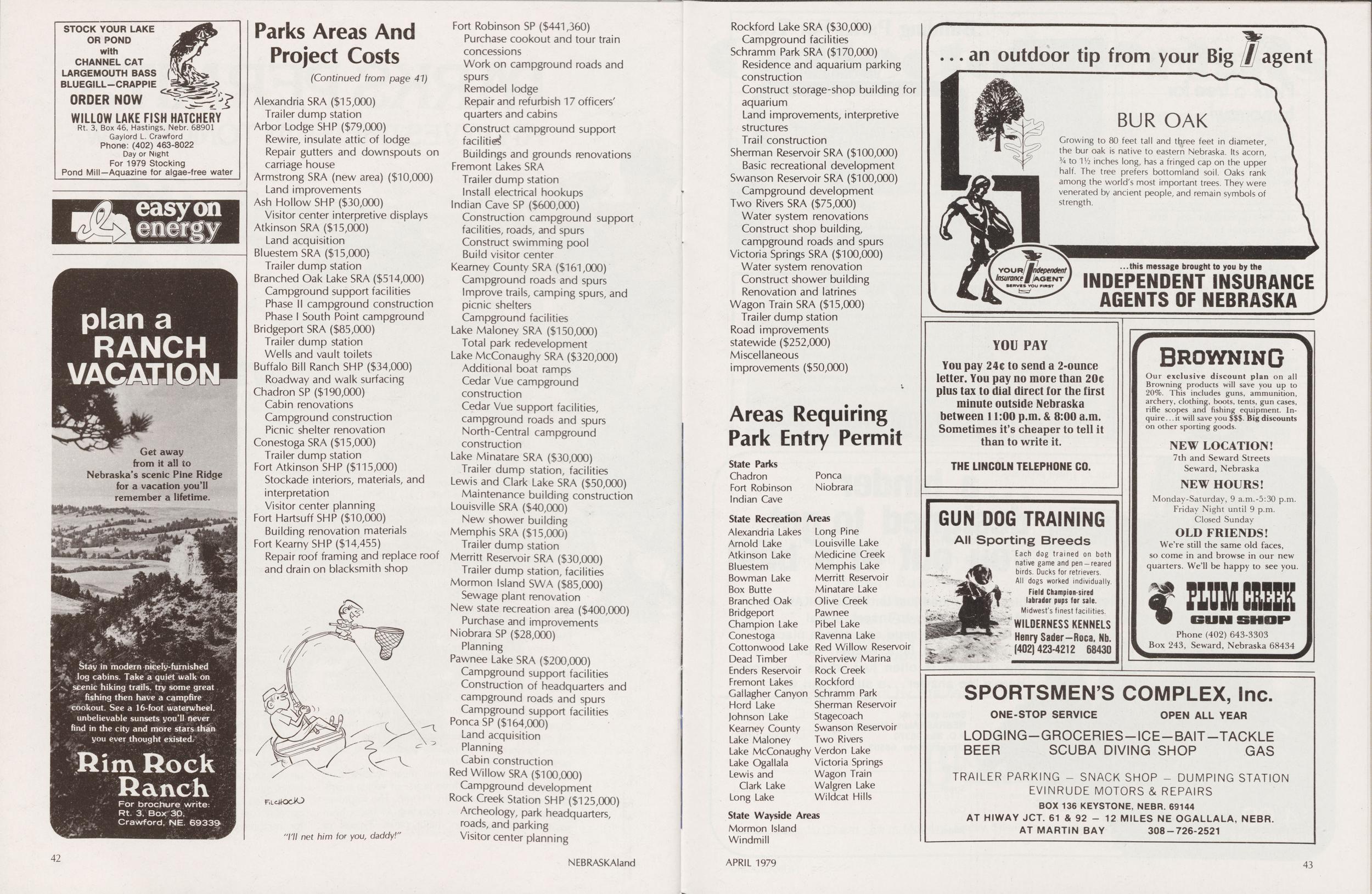
Parks Areas And Project Costs
(Continued from page 41) Alexandria SRA ($15,000) Trailer dump station Arbor Lodge SHP ($79,000) Rewire, insulate attic of lodge Repair gutters and downspouts on carriage house Armstrong SRA (new area) ($10,000) Land improvements Ash Hollow SHP ($30,000) Visitor center interpretive displays Atkinson SRA ($15,000) Land acquisition BluestemSRA ($15,000) Trailer dump station Branched Oak Lake SRA ($514,000) Campground support facilities Phase II campground construction Phase I South Point campground Bridgeport SRA ($85,000) Trailer dump station Wells and vault toilets Buffalo Bill Ranch SHP ($34,000) Roadway and walk surfacing Chadron SP ($190,000) Cabin renovations Campground construction Picnic shelter renovation Conestoga SRA ($15,000) Trailer dump station Fort Atkinson SHP ($115,000) Stockade interiors, materials, and interpretation Visitor center planning Fort Hartsuff SHP ($10,000) Building renovation materials Fort Kearny SHP ($14,455) Repair roof framing and replace roof and drain on blacksmith shopI'll net him for you, daddy!
Areas Requiring Park Entry Permit
State Parks Chadron Fort Robinson Indian Cave Ponca Niobrara State Recreation Areas Alexandria Lakes Long Pine Arnold Lake Louisville Lake Atkinson Lake Medicine Creek Bluestem Memphis Lake Bowman Lake Minatare Lake Branched Oak Olive Creek Bridgeport Pawnee Champion lake Pibel Lake Conestoga Ravenna Lake Cottonwood Lake Red Willow Reservoir Dead Timber Riverview Marina Enders Reservoir Rock Creek Fremont Lakes Rockford Gallagher Canyon Schramm Park Hord Lake Sherman Reservoir Johnson Lake Stagecoach Kearney County Swanson Reservoir Lake Maloney Two Rivers Lake McConaughy Verdon Lake Lake Ogallala Victoria Springs Lewis and Wagon Train Clark Lake Walgren Lake Long Lake Wildcat Hills State Wayside Areas Mormon Island Windmill
FISHING THE FORT
(Continued from page 17)the upper watersheds have been fenced out as well, to prevent run-off and to preserve native habitat.
With the pond projects well underway by mid 1978, biologists turned to the improvement of the fishery maintained by Carter P. Johnson Lake located above the Fort complex on the Soldier's Creek access road.
At 23 acres, Carter P. Johnson has held a good population of sizable largemouth bass, as well as a stunted bluegill population, with anglers reporting good success on bass to five pounds. By mid-summer, however, heavy vegetation nearly prevented all fishing access, which contributed to the stunted bluegill problem. Without the heavy vegetation, largemouth could better utilize the bluegill for forage and control their numbers, allowing better growth among the remaining fish. The vegetation also hampered boat access to Carter P. Johnson.
The lake was treated chemically to help control vegetation, and successful access to the lake from the shoreline and by rowboat during the late summer and fall proved the effectiveness of chemical treatment. Carter P. Johnson is expected to provide good largemouth and bluegill angling.
The outlet structure of the dam was raised, increasing the holding capacity in Carter P. Johnson Lake by two feet. This increase may be used to provide water to the Crazy Horse diversion below the dam to create another warm-water fishery. The existing Crazy Horse structure holds a small amount of water, but lack of flow from Carter P. Johnson during late summer creates a stagnating pool.
There are approximately 13 miles of the White River flowing through Fort Robinson, and nearly 11 miles of Soldier's Creek within the park boundary. An additional 10 miles of Soldier's Creek on the adjacent Wood Reserve brings the total to 34 miles of quality trout-supporting water available to the public.
Both Soldier's Creek and the White River will be stocked with catchable trout at least once every 28 days, and an alternating schedule allows stocking of catchable trout once every 14 days. Approximately 10,000 catchables, including brown trout, rainbow trout, and brook trout, will be stocked annually at Fort Robinson.
Additionally, biologists stocked bullfrog tadpoles at eight sites on the park to help re-establish them, as they provided a once harvestable population.
Maps and guides to the fine fishing waters of Fort Robinson can be obtained from one of the offices of the Nebraska Game and Parks Commission in Norfolk, Omaha, Lincoln, Bassett, North Platte, and Alliance, or from the information booth at the Fort Robinson headquarters.
Bookshelf
THE BADLANDS Time-Life Books New York $8.95 Clark, Champ. 1974This is one of the American Wilderness series, which complements the Time-Life Nature Library of a few years ago. The Badlands concentrates on the White River and Little Missouri River badlands of the Dakotas, but much of the information applies generally to northwestern Nebraska, as well. Descriptions of geology, climate, plants and animals provide as understanding of how the badlands developed and how living things have adapted to this harsh environment.
Throughout the book, an abundance of plant photos in color somehow seem out of place in what has come to be thought of as a barren and rainless land. A fairly detailed, well illustrated chapter deals with prairie dogs and their animal neighbors, such as burrowing owls and bison. One especially interesting photo series shows how bison use the bare mounds of the "dog town" for their dust baths. After such an episode, there's nothing for the prairie dogs to do but start remodeling their battered homes.
The early explorers and scientists who ventured into the Badlands found an abundance of natural wonders. Over the years, geological expeditions dug out and cataloged literally tons of fossils which may now be seen in museums throughout the world.
A short photo essay hits the high points of Theodore Roosevelt's interlude as a Badlands rancher in southwestern North Dakota. The Roosevelt Ranch and several thousand additional acres now comprise a National Memorial Park; a beautiful though little-known glimpse of the Old West.
NOTES ON NEBRASKA FAUNA
COMMON MERGANSER
A LARGE, ATTRACTIVE duck, the Common Merganser has a scientific name of Mergus merganser americanus, which is misleading in that this duck actually occurs throughout the northern hemisphere. It may be known as the American Merganser, goosander, sheldrake, fish duck and sawbill.
The Common Merganser is one of the largest ducks occurring in Nebraska. Males may reach 27 inches in length with a wingspan of over two feet. The largest adult males may weigh up to 41/2 pounds but probably average 31/2. Females are smaller and lighter, averaging only 23A pounds. Immature birds run Va to 1/2-pound lighter than adults.
These long, streamlined ducks fly with rapid wing beats in small flocks, generally in trailing lines that give the appearance of a single file. They typically fly low over the water, and their straight, fast and often low flight is a good clue to their identification.
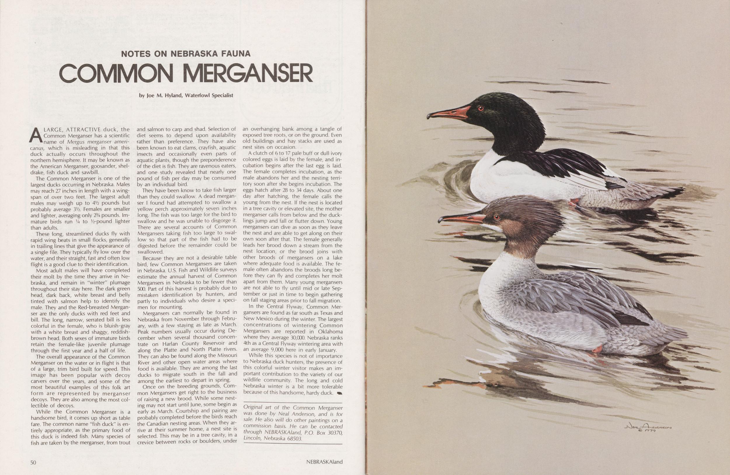
Most adult males will have completed their molt by the time they arrive in Nebraska, and remain in "winter" plumage throughout their stay here. The dark green head, dark back, white breast and belly tinted with salmon help to identify the male. They and the Red-breasted Merganser are the only ducks with red feet and bill. The long, narrow, serrated bill is less colorful in the female, who is bluish-gray with a white breast and shaggy, reddish-brown head. Both sexes of immature birds retain the female-like juvenile plumage through the first year and a half of life.
The overall appearance of the Common Merganser on the water or in flight is that of a large, trim bird built for speed. This image has been popular with decoy carvers over the years, and some of the most beautiful examples of this folk art form are represented by merganser decoys. They are also among the most collectible of decoys.
While the Common Merganser is a handsome bird, it comes up short as table fare. The common name "fish duck" is entirely appropriate, as the primary food of this duck is indeed fish. Many species of fish are taken by the merganser, from trout and salmon to carp and shad. Selection of diet seems to depend upon availability rather than preference. They have also been known to eat clams, crayfish, aquatic insects and occasionally even parts of aquatic plants, though the preponderence of the diet is fish. They are ravenous eaters, and one study revealed that nearly one pound of fish per day may be consumed by an individual bird.
They have been know to take fish larger than they could swallow. A dead merganser I found had attempted to swallow a yellow perch approximately seven inches long. The fish was too large for the bird to swallow and he was unable to disgorge it. There are several accounts of Common Mergansers taking fish too large to swallow so that part of the fish had to be digested before the remainder could be swallowed.
Because they are not a desirable table bird, few Common Mergansers are taken in Nebraska. U.S. Fish and Wildlife surveys estimate the annual harvest of Common Mergansers in Nebraska to be fewer than 500. Part of this harvest is probably due to mistaken identification by hunters, and partly to individuals who desire a specimen for mounting.
Mergansers can normally be found in Nebraska from November through February, with a few staying as late as March. Peak numbers usually occur during December when several thousand concentrate on Harlan County Reservoir and along the Platte and North Platte rivers. They can also be found along the Missouri River and other open water areas where food is available. They are among the last ducks to migrate south in the fall and among the earliest to depart in spring.
Once on the breeding grounds, Common Mergansers get right to the business of raising a new brood. While some nesting may not start until June, some begin as early as March. Courtship and pairing are probably completed before the birds reach the Canadian nesting areas. When they arrive at their summer home, a nest site is selected. This may be in a tree cavity, in a crevice between rocks or boulders, under an overhanging bank among a tangle of exposed tree roots, or on the ground. Even old buildings and hay stacks are used as nest sites on occasion.
A clutch of 6 to 17 pale buff or dull ivory colored eggs is laid by the female, and incubation begins after the last egg is laid. The female completes incubation, as the male abandons her and the nesting territory soon after she begins incubation. The eggs hatch after 28 to 34 days. About one day after hatching, the female calls the young from the nest. If the nest is located in a tree cavity or elevated site, the mother merganser calls from below and the ducklings jump and fall or flutter down. Young mergansers can dive as soon as they leave the nest and are able to get along on their own soon after that. The female generally leads her brood down a stream from the nest location, or the brood joins with other broods of mergansers on a lake where adequate food is available. The female often abandons the broods long before they can fly and completes her molt apart from them. Many young mergansers are not able to fly until mid or late September or just in time to begin gathering on fall staging areas prior to fall migration.
In the Central Flyway, Common Mergansers are found as far south as Texas and New Mexico during the winter. The largest concentrations of wintering Common Mergansers are reported in Oklahoma where they average 30,000. Nebraska ranks 4th as a Central Flyway wintering area with an average 9,000 here in early January.
While this species is not of importance to Nebraska duck hunters, the presence of this colorful winter visitor makes an important contribution to the variety of our wildlife community. The long and cold Nebraska winter is a bit more tolerable because of this handsome, hardy duck.
Original art of the Common Merganser was done by Neai Anderson, and is for sale. He also will do other paintings on a commission basis. He can be contacted through NEBRASKAland, P.O. Box 30370, Lincoln, Nebraska 68503.
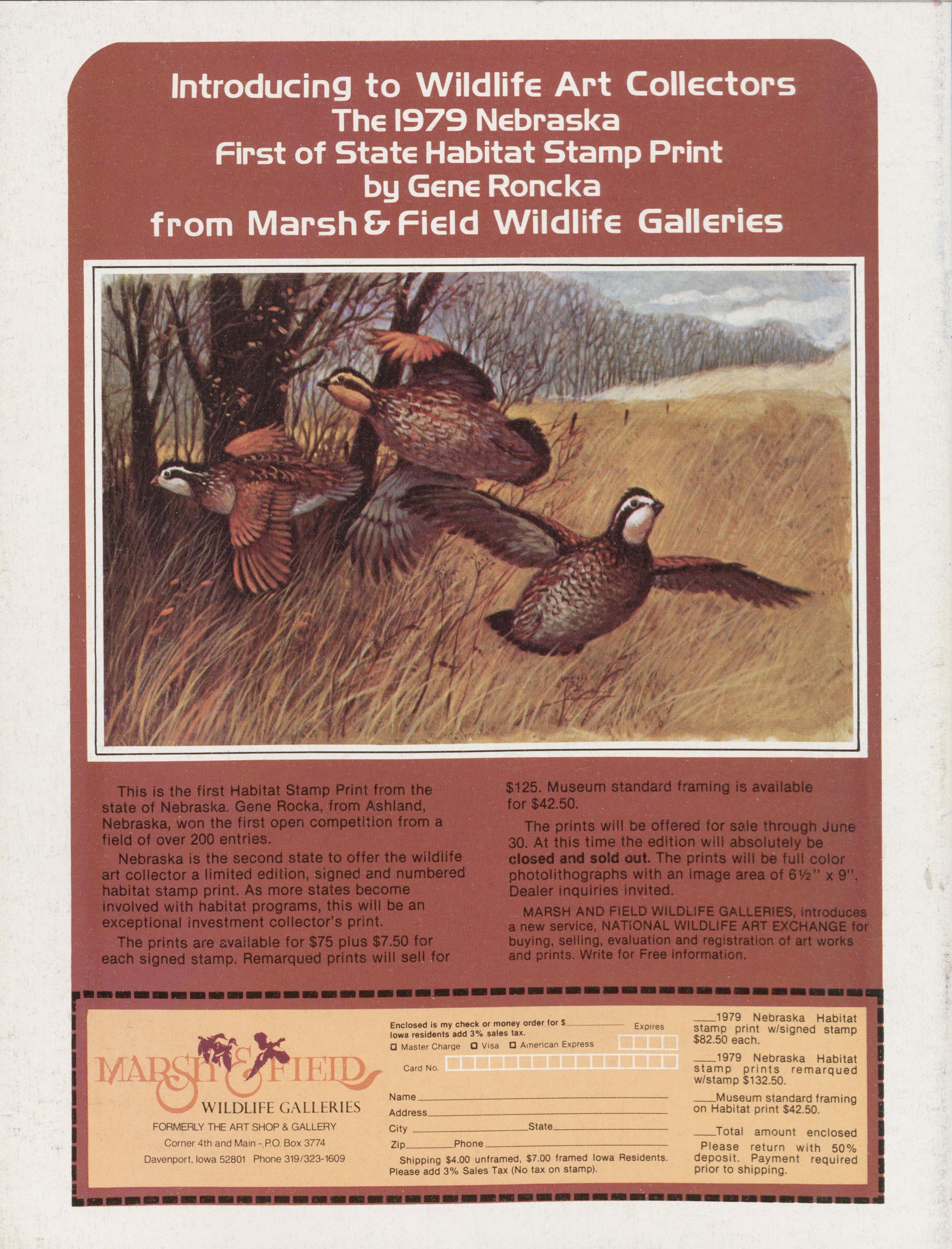
Introducing to Wildlife Art Collectors The 1979 Nebraska First of State Habitat Stamp Print by Gene Roncka from Marsh & Field Wildlife Galleries
This is the first Habitat Stamp Print from the state of Nebraska. Gene Rocka, from Ashland, Nebraska, won the first open competition from a field of over 200 entries. Nebraska is the second state to offer the wildlife art collector a limited edition, signed and numbered habitat stamp print. As more states become involved with habitat programs, this will be an exceptional investment collector's print. The prints are available for $75 plus $7.50 for each signed stamp. Remarqued prints will sell for $125. Museum standard framing is available for $42.50. The prints will be offered for sale through June 30. At this time the edition will absolutely be closed and sold out. The prints will be full color photolithographs with an image area of 6V2" x 9". Dealer inquiries invited. MARSH AND FIELD WILDLIFE GALLERIES, introduces a new service, NATIONAL WILDLIFE ART EXCHANGE for buying, selling, evaluation and registration of art works and prints. Write for Free information. WILDLIFE GALLERIES FORMERLY THE ART SHOP & GALLERY Corner 4th and Main - RO. Box 3774 Davenport, Iowa 52801 Phone 319/323-1609 Enclosed is my check or money order for $ Iowa residents add 3% sales tax. 0 Master Charge Q Visa U American Express Card No. Expires Name. State, Phone Shipping $4.00 unframed, $7.00 framed Iowa Residents. Please add 3% Sales Tax (No tax on stamp) 1979 Nebraska Habitat stamp print w/signed stamp $82.50 each. 1979 Nebraska Habitat stamp prints remarqued w/stamp $132.50. Museum standard framing on Habitat print $42.50. Total Please deposit. Payment prior to shipping amount enclosed return with 50% requiredPosition: 467 (22 views)